Illustrated Map for Boggy Creek Airboat Adventures
Client: Boggy Creek Airboat Adventures
Visit The Boggy Creek Airboat Adventures website at BCAirboats.com
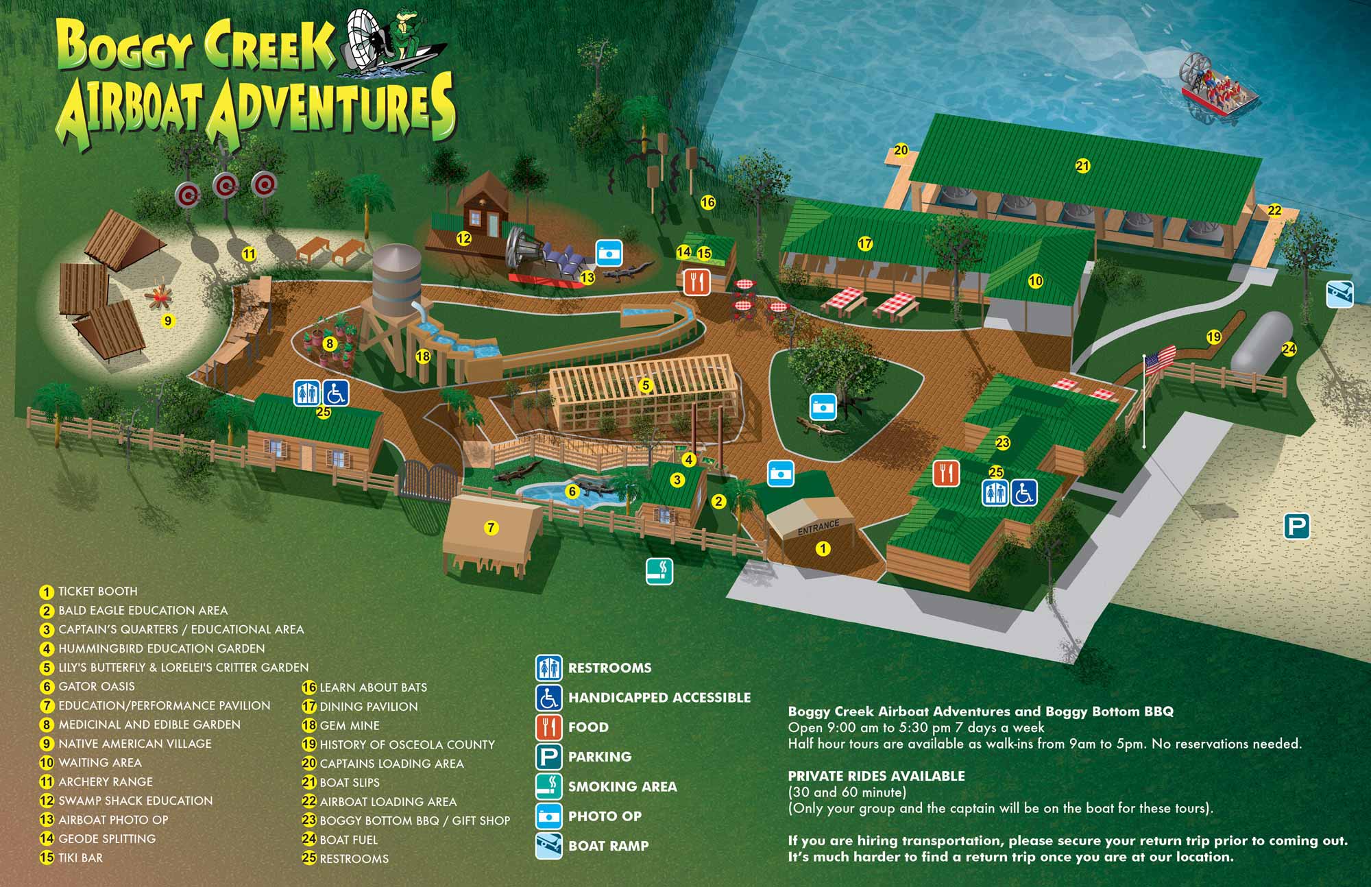
Boggy Creek Airboat Adventures is a small but impressive attraction in Kissimmee, FL. It's not part of the whole Disney, Universal thing. It's an outdoor Florida nature adventure with plenty of relaxation and kid's activities as well. As the name implies the primary draw are the airboat tours on Lake Tohopekaliga where you're bound to see lots of wildlife including alligators.
The client had an existing illustrated map but wanted to make some revisions and step up the style to something that looked more professional. They wanted an isometric look, which is a little cartoony, so I created the illustration entirely in Adobe Illustrator. The existing map helped some but it wasn't to scale and I always work to scale. I used aerial/satellite photography for reference and I used Google May Maps to mark up everything and verify that my placement and labeling was accurate. This is a tool I use a lot. It can save a lot of time and unnecessary correspondence.
Maps like this can take several layers as the geometry becomes too complex and my computer bogs down. Once a layer becomes too complex I convert the vector file to a flat bitmap. I then place it in a new file with the same proportions in Illustrator and continue adding more details, buildings or whatever is needed as vector art. Once the illustration part is complete I flatten the whole thing to a flat bitmap, place it in a new file of with the same proportions in Illustrator and create the keying and labeling etc.. This will become final files for the client so that they can make minor revisions in house. Changes to the illustration would require my intervention. I also provide files in web friendly formats (JPG and PDF).
I know the client is using the map on their website. I don't know if they used it for signage but I do think they use it for printed handouts.


ILLUSTRATED PARK MAPS:
Illustrated park maps play an important role in helping visitors feel comfortable, informed, and confident as they explore a space. If you manage a botanical garden, work for a Parks and Recreation department, or oversee a public attraction, clear wayfinding is a key part of creating a positive guest experience. A well designed map reduces confusion, supports accessibility, and allows visitors to focus on enjoying the park rather than trying to figure out where they are.
The term park covers a wide range of destinations, from neighborhood ball fields and community parks to large nature preserves, wildlife sanctuaries, botanical gardens, theme parks, and agritourism venues. Over the years I have illustrated maps for many types of parks, each with its own layout, audience, and goals. In every case, the objective is the same: to present geographic information in a way that is easy to understand, visually engaging, and appropriate for the setting.
Each illustrated park map is tailored to the specific site and its visitors. Some projects call for a more realistic representation of the landscape, while others benefit from a lighter, more playful illustration style. Factors such as size, visitor flow, signage needs, and branding all influence the final approach. When you contact me about a park map, we will discuss your goals and challenges in detail and determine the style and level of detail that best supports your venue and your guests.
EXPLORE MY PORTFOLIOS
- Illustration: Find custom illustration, book covers, illustrated maps, and architectural rendering.
- Fine Art: Browse original paintings and drawings, the Custom Halftone Series, and murals.
- Graphic Design & Motion: See my graphic design work, plus motion design and animated illustrations.
- Maps by industry: Illustrated maps tailored for boat shows, resorts, marinas, real estate, transit & parking, towns & cities, parks, and wayfinding.
- Other project types: Also available: cover art, vehicle & vinyl wraps, proposal renderings, and street art.
- Techniques: Explore work in vector, isometric & axonometric, painting, black & white, GeoData, overhead, and halftone styles.
- Software: Primary tools: Photoshop, Illustrator, SketchUp Pro, and InDesign. Motion work uses Premiere Pro & After Effects.