A Partnership Since 2018

For information on Global Marine Travels please visit FlyGMT.com
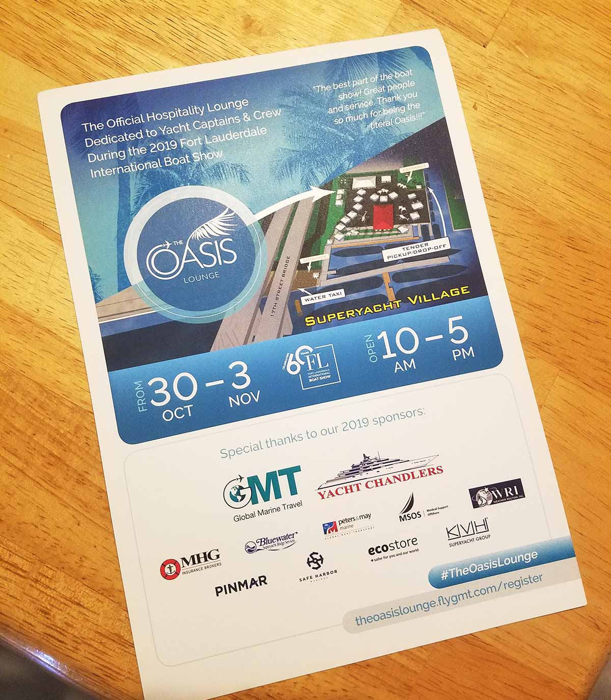
I have been working with Global Marine Travel since 2019. My main job has been creating illustrated maps to promote their Oasis VIP Lounge at the Fort Lauderdale International Boat Show. The Oasis Lounge is designed for Superyacht Captains and Crew, offering everything from gourmet food to a fully stocked bar, live music, Wi Fi, and streaming of live sports.
About Global Marine Travel
Global Marine Travel is the leading travel management company for the maritime industry. They serve customers across commercial shipping, offshore operations, government, leisure, crew transport, superyachts, corporate travel, and marine support sectors.
Their team of professionals is available 24 hours a day, seven days a week. They offer specialized airfares, use modern technology to streamline bookings, and bring years of experience with airline schedules and visa requirements. The goal is always the same. Provide cost savings and superior service to every client.
Two Locations, Two Experiences
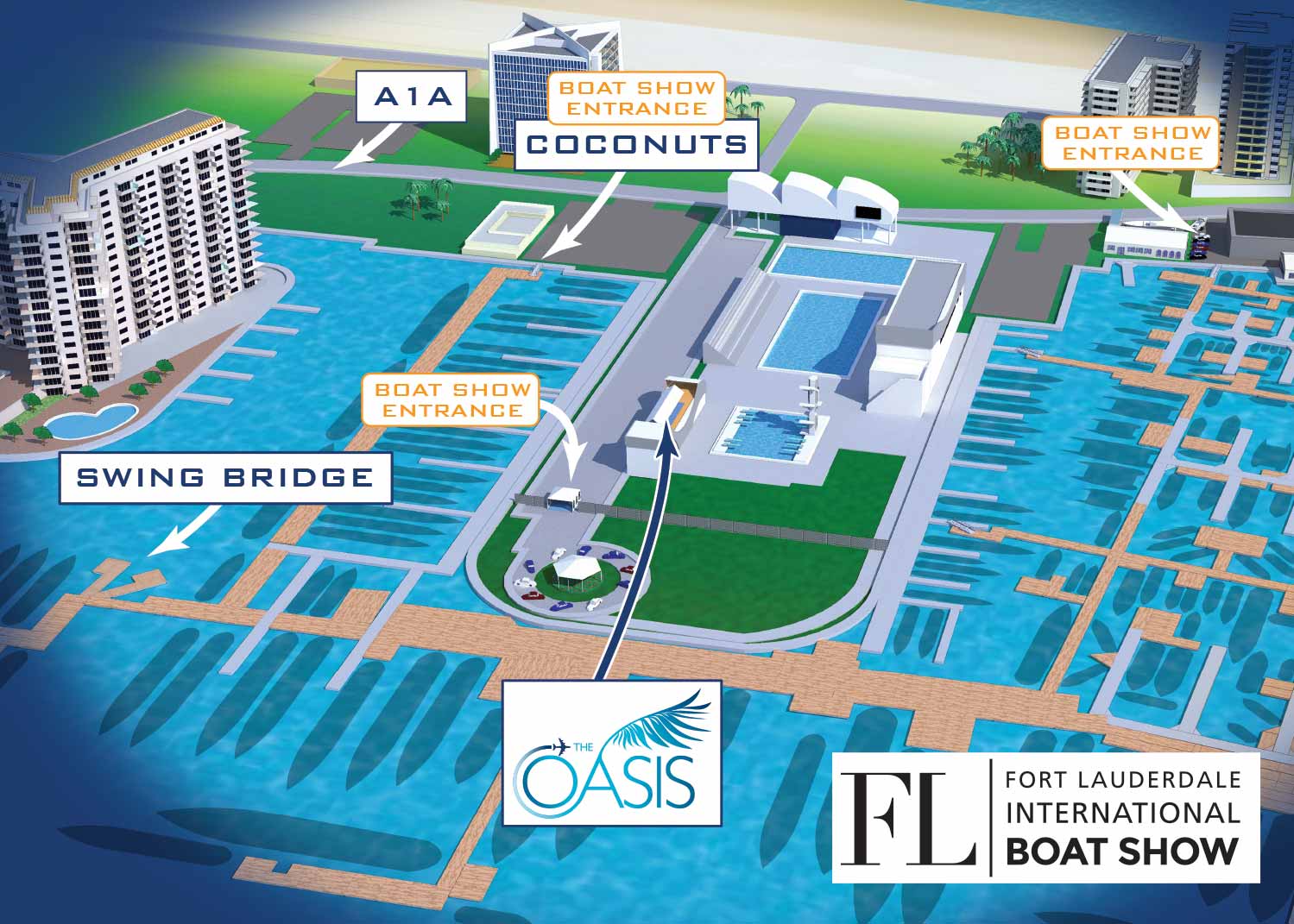
Today there are actually two Oasis locations at the show.
The first Oasis is at the Bahia Mar venue, near the Swimming Hall of Fame. This location serves all superyacht crew during lunch, with a variety of sandwiches and salads available for dining in or taking to go.
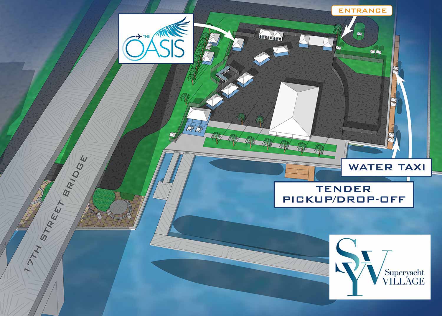
The second Oasis sits inside the Superyacht Village at Pier Sixty Six. This space has an indoor outdoor atmosphere, perfect for relaxing and connecting with friends. Dining tables let guests enjoy a catered lunch buffet before heading back to work refreshed and ready to welcome more visitors.
What I Provide
I supply Global Marine Travel with unique, one of a kind illustrated maps for each location. These maps highlight points of interest and are designed to work across multiple formats. They have been used as on site signage at the show, in printed mailers and flyers, and as online marketing materials. That means each map gets maximum use, serving both wayfinding and promotional purposes.
Before the show even starts, Global Marine Travel can use these maps to promote the lounge in a way that is genuinely informative. Potential guests get a real sense of where the lounge is and what to expect. It is a more useful approach than relying on stock photos of people having fun, which look good but do not actually tell anyone anything.
The Method Behind the Maps
You may already know that I create illustrated maps annually for all the biggest boat shows in North America, working with companies like Informa Markets and Revel Republic. For each show I build a three dimensional digital model of the venue and the surrounding area. Those models are the foundation of every map I make. I update them every year based on data from show management companies, including new dock layouts, exhibitor locations, transportation options, and available facilities.
Maps Made for One Client
The beauty of working from a 3D digital model is that I can render it from any angle and at any zoom level. That means I can create unique views tailored to a specific client's needs. If someone wants a map that focuses on their exhibit area with just enough surrounding context to orient visitors, I can do that. I can spin the model around until I find the angle that works best. That is exactly what I do for Global Marine Travel each year.
What I Can Do for You
If you have a booth, an exhibit area, or any other featured space at one of the boat shows I map, I can provide a unique, custom illustrated map for your marketing and wayfinding needs. This is your chance to show your clients something real and useful, not just glossy photos of models pretending to have a good time.
Contact me if you are interested. I have done this work before and I would be glad to do it for you.
WORK FOR GLOBAL MARINE TRAVEL:


PORTFOLIOS
- Illustration Portfolio: Start here for custom illustration and book covers. You can also browse illustrated maps and architectural rendering.
- Fine Art: I offer original paintings and drawings, including my Custom Halftone Series. You will also find mural work here.
- Graphic Design & Motion: View my graphic design portfolio. After that, explore motion design and animated illustrations.
- Maps by application: I create illustrated maps for boat shows, resorts, marinas, real estate, transportation, transit and parking, towns and cities, parks, and wayfinding.
- Additional project types: I also produce cover illustration, vehicle and vinyl wraps, proposal renderings, and street art.
- Illustration methods: My techniques include vector, isometric and axonometric, painting, black and white, GeoData maps, overhead maps, and custom halftones.
- Software portfolios: I work primarily in Adobe Photoshop, Adobe Illustrator, SketchUp Pro, and Adobe InDesign. For motion projects, I use Premiere Pro and After Effects.