Illustrated Overhead Map for Paradise Palms Botanical & Sculpture Gardens in Delray Beach, FL
I created this map. This site is about my work as an artist, illustrator and designer.
At present the 10-acre palm tree garden is open to the public by appointment only from 10:00 a.m. to 4:00 p.m. on Wednesdays, Thursdays, and Saturdays. For more (and the latest) information about Paradise Palms Botanical & Sculpture Gardens please visit their site ParadisePalms.org.
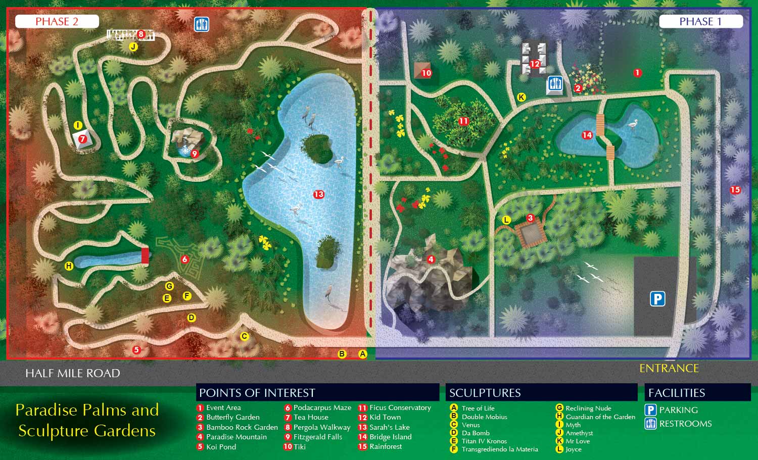
Paradise Palms Botanical & Sculpture Gardens (PPB&SG) is dedicated to a dual mission: to educate the public on the remarkable beauty, diversity, and utility of palm trees while offering artists an ideal environment to foster creativity and well-being by presenting a significant collection of contemporary sculpture within this unique natural landscape.
To help visitors navigate and explore this expansive destination, I was commissioned to create a detailed overhead map. The client requested a clean, illustrative style that prioritized clarity, with the network of trails as the central focus. The project presented a unique challenge, as the gardens are large and intricate with no existing site plans for reference. My process involved multiple site visits to collect GPS data and photographs, supplemented by satellite imagery. This groundwork was followed by an extensive collaborative revision process with the client to ensure every path and feature was accurately represented.
The final product is a custom vector based illustrated map that balances informative detail with visual appeal. The design distinguishes between the garden's Phase One and Phase Two areas using a simple color coded system. The surrounding road and main entrance are clearly labeled on the illustration. A clear keying system guides exploration: points of interest are marked with numerals on red dots, individual sculptures are identified with black letters on yellow dots, and essential facilities are indicated with a set of intuitive graphical icons. Each unique visual treatment for the points of interest is designed to convey a sense of the discovery awaiting visitors.
As a professional map illustrator, I specialize in transforming complex spaces into clear, engaging, and useful navigational tools. This map for Paradise Palms serves as both a practical guide for guests and an elegant piece of interpretive graphics that reflects the garden's mission.
Explore the gardens with confidence. Let a custom illustrated map be the key to your visitor experience. Discover more examples of my cartography and illustration work in my Maps or Illustration Portfolio.
OVERHEAD MAPS:


PORTFOLIOS
- Illustration Portfolio: Start here for custom illustration and book covers. You can also browse illustrated maps and architectural rendering.
- Fine Art: I offer original paintings and drawings, including my Custom Halftone Series. You will also find mural work here.
- Graphic Design & Motion: View my graphic design portfolio. After that, explore motion design and animated illustrations.
- Maps by application: I create illustrated maps for boat shows, resorts, marinas, real estate, transportation, transit and parking, towns and cities, parks, and wayfinding.
- Additional project types: I also produce cover illustration, vehicle and vinyl wraps, proposal renderings, and street art.
- Illustration methods: My techniques include vector, isometric and axonometric, painting, black and white, GeoData maps, overhead maps, and custom halftones.
- Software portfolios: I work primarily in Adobe Photoshop, Adobe Illustrator, SketchUp Pro, and Adobe InDesign. For motion projects, I use Premiere Pro and After Effects.