Illustrated map of a wildlife sanctuary, aviary, and botanical garden - Botanical Gardens Map
Illustration and design by John Potter
Client: Flamingo Gardens
For information on Flamingo Gardens botanical garden and wildlife sanctuary please visit their website at FlamingoGardens.org
Original Map | 2016 Map | 2022 Map
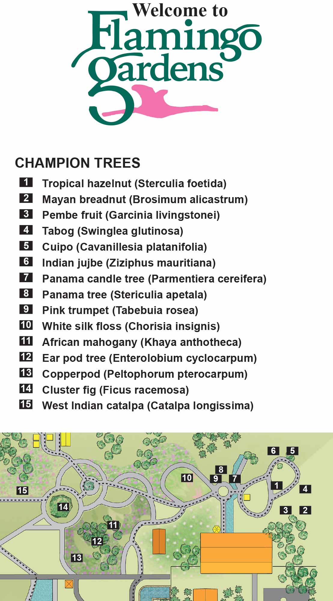
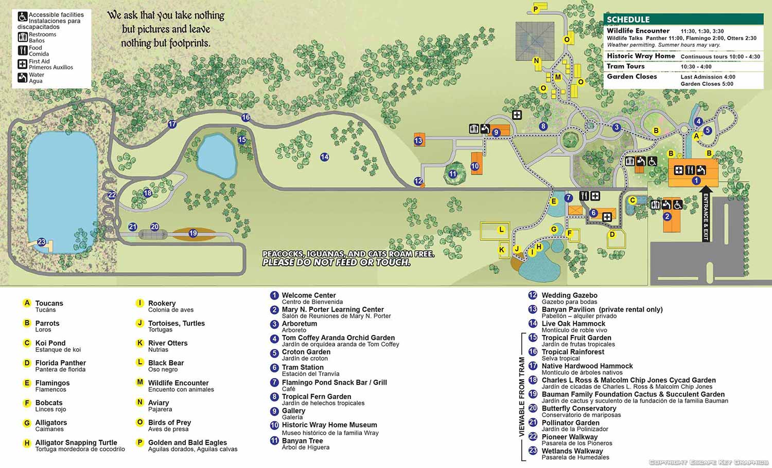
Flamingo Gardens is a well known wildlife sanctuary, aviary, and botanical garden located in South Florida. The property is home to native Florida wildlife, including alligators, birds of prey, and other protected species, as well as one of the region’s largest collections of champion trees and carefully maintained gardens. Visitors are drawn to Flamingo Gardens for an experience that combines education, conservation, and natural beauty in a setting that is both approachable and visually memorable.
This illustrated map is a redesign of an earlier version I originally created in 2009. While the original map served its purpose for many years, visitor feedback indicated that it could be difficult to follow, and the layout was ready for a more modern and accessible approach. The updated map focuses on improved clarity and readability while preserving the character and atmosphere of the gardens.
For this revision, the client requested a direct overhead view paired with a soft, sandy color palette that reflects the natural environment of South Florida. The overhead perspective allows visitors to quickly understand the layout of the grounds, making it easier to locate exhibits, gardens, walking paths, and amenities at a glance. Accuracy and visual warmth were balanced carefully so the map functions as both a practical wayfinding tool and an inviting illustration that encourages exploration.
This project is part of an ongoing working relationship with Flamingo Gardens. In addition to the primary illustrated map, I also created original artwork for the brochure side of the map and designed other promotional materials, including a rack card. All pieces were developed to maintain a consistent visual identity while clearly communicating information to a wide range of visitors.
Illustrated maps like this are especially effective for botanical gardens, wildlife attractions, museums, and public venues that want to improve wayfinding while reinforcing their brand. A well designed map helps visitors feel comfortable navigating the space and becomes a lasting part of the overall experience. If you are looking to hire an illustrator to create a custom map for a garden, park, or visitor attraction, this project demonstrates how thoughtful illustration can support both navigation and marketing goals.


ILLUSTRATED PARK MAPS:
Illustrated park maps play an important role in helping visitors feel comfortable, informed, and confident as they explore a space. If you manage a botanical garden, work for a Parks and Recreation department, or oversee a public attraction, clear wayfinding is a key part of creating a positive guest experience. A well designed map reduces confusion, supports accessibility, and allows visitors to focus on enjoying the park rather than trying to figure out where they are.
The term park covers a wide range of destinations, from neighborhood ball fields and community parks to large nature preserves, wildlife sanctuaries, botanical gardens, theme parks, and agritourism venues. Over the years I have illustrated maps for many types of parks, each with its own layout, audience, and goals. In every case, the objective is the same: to present geographic information in a way that is easy to understand, visually engaging, and appropriate for the setting.
Each illustrated park map is tailored to the specific site and its visitors. Some projects call for a more realistic representation of the landscape, while others benefit from a lighter, more playful illustration style. Factors such as size, visitor flow, signage needs, and branding all influence the final approach. When you contact me about a park map, we will discuss your goals and challenges in detail and determine the style and level of detail that best supports your venue and your guests.
PORTFOLIO SELECTIONS
- Custom illustration & covers: Featuring bespoke illustration, book and magazine covers, hand-drawn maps, and building renderings.
- Fine art & murals: Including one-of-a-kind paintings and drawings, the Custom Halftone Series, and large-scale murals.
- Design & motion media: Covering graphic design, plus video and motion and animated illustration.
- Mapping by application: Tailored maps for marine events, hospitality, waterfront, property, transit, municipal, recreation, and navigation needs.
- Additional creative work: Includes editorial covers, vehicle graphics, concept renderings, and public art.
- Mediums & formats: Ranging from digital vector and isometric projection to traditional paint, line art, GIS-based, aerial-style, and halftone.
- Software expertise: Proficient in Photoshop, Illustrator, SketchUp, InDesign, and Premiere/After Effects for motion.