Illustrated Map for the Suncoast Boat Show in Sarasota, Florida
Client: Informa Markets
I am the illustrator and designer of this map. If that is what you are interested in please proceed to explore my site.
If you want the latest and most accurate information about attending the Suncoast Boat Show please visit their official site at SuncoastBoatShow.com
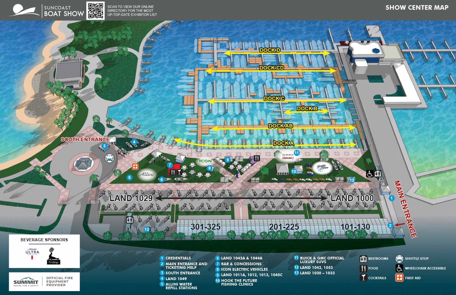
The 2025 Suncoast Boat Show map reflects the latest layout for the Sarasota, Florida event with updated floating dock configurations and land exhibitor placements. These annual adjustments are rendered from the dedicated three dimensional digital model that serves as the geographic foundation for this venue.
The graphic design for 2025 received a refreshed and more cohesive presentation. A new minimalist header was introduced, establishing greater visual continuity with the standard look and feel of Informa's other boat shows. To improve the readability of text in the lower section, I applied a darkened gradient overlay to the bottom of the illustration, allowing the reverse copy to stand out more clearly. The previous corporate identity footer was removed, also in line with the standardized branding approach. This adjustment created space to reposition the sponsor logo box and relocate the key for the graphical icons indicating facilities and amenities to the lower right corner. As always, the text listings for points of interest and the number spans for dock displays were updated to reflect the current year's information.
The absence of requests for major structural revisions is a strong indicator of good foundational design and insightful initial planning. When working on event maps, it is common to encounter multiple rounds of revisions, sometimes with last minute requests. Because I operate with a standardized, efficient workflow and bring over a decade of specialized experience to each project, I am well equipped to manage these smoothly. It is important to note that even minor client requests can necessitate precise adjustments across several files using multiple software applications. This is where the value of a well organized, professional illustrator and designer becomes pivotal, ensuring changes are executed correctly and delivered on time.
This map serves multiple functions. It is used in print materials, on the event website, within the mobile application, and on signage throughout the show. Prior to the event, the map acts as a valuable marketing tool, representing the show in an accurate and informative visual format. While other promotional visuals may focus on projecting an atmosphere, a detailed map provides concrete information. This allows potential attendees to effectively plan and visualize their time at the show, transforming anticipation into a practical guide.
For more examples of my illustrative cartography for marine events, please visit my Maps Portfolio.
MAPS FOR SUNCOAST BOAT SHOW:
Suncoast Boat Show:
I have created illustrated maps for Suncoast boat shows since 2021, supporting events that serve both serious boaters and a broader regional audience along Florida's Gulf Coast. These shows are known for their welcoming atmosphere and strong connection to the local boating community, and my goal has been to reflect that character while delivering maps that are clear, accurate, and easy to use.
Suncoast boat shows typically combine enclosed exhibition spaces with outdoor display areas, parking, and surrounding amenities. This mix requires careful planning to help guests understand how the event is laid out before they arrive and navigate it while there. I focus on presenting the venue from an aerial view that allows visitors to quickly identify entrances, exhibitor zones, key attractions, and essential services. The result is a map that supports smooth movement through the show and reduces confusion during busy event days.
The map is designed to adapt across multiple formats, including printed show guides, signage, and digital use on websites and mobile devices. I rely on consistent visual systems such as numbered keying for primary destinations and icon based symbols for recurring amenities like restrooms, food areas, and information points. This approach keeps the map readable and efficient while allowing last minute updates without disrupting the overall design.
Boat shows benefit from maps that balance practical navigation with a clean, professional presentation. My experience illustrating marine events throughout the US (and some abroad) allows me to create maps that meet operational needs while reinforcing the branding and identity of the show. For event organizers and exhibitors, a well designed illustrated map becomes an important tool that improves the visitor experience and helps the show run smoothly from opening day to closing.


BROWSE MY WORK
- Illustration: Browse custom illustrations, book cover art, illustrated maps, and architectural renderings.
- Fine art: View original paintings and drawings, the Custom Halftone Series, and mural commissions.
- Graphic design & motion: See design projects, then watch motion reels and animated pieces.
- Maps by use case: Explore illustrated maps created for boat shows, resorts, marinas, real estate, transportation & parking, cities & towns, parks, and wayfinding.
- Specialty projects: Also check out cover design, vinyl & vehicle wraps, proposal renderings, and street art.
- Style & technique: Discover vector, isometric, painterly, monochrome, data-driven, bird's-eye, and halftone approaches.
- Tools I use: Everyday software includes Photoshop, Illustrator, SketchUp, and InDesign; motion work relies on Premiere & After Effects.