Illustrated Boat Show Map for Exhibitors and Guests
For information on attending the Saint Petersburg Power and Sailboat Show please visit StPeteBoatShow.com
St. Petersburg Power & Sailboat Show Maps
- About St. Petersburg Power & Sailboat Show
- 2026 | 2025 | 2024 | 2023 | 2022 | 2021 | 2019 | 2018 | 2017 | 2016 | 2015 | 2014 | 2013 | 2012 | 2011
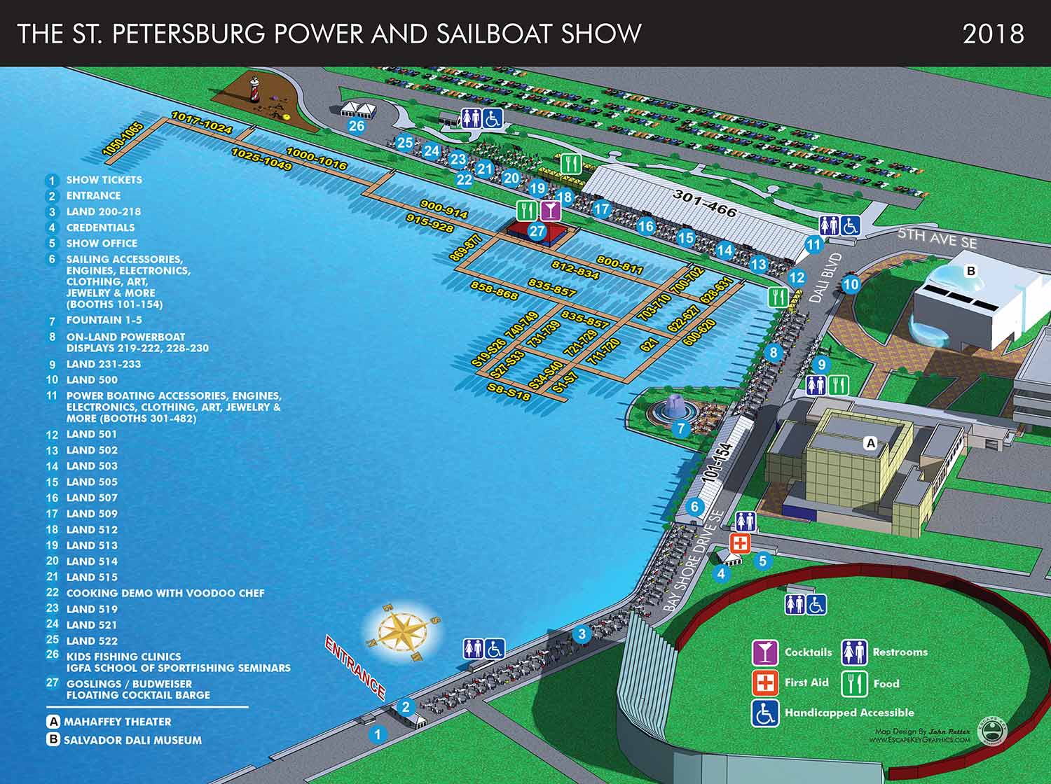
This year's map is zoomed out a little more to accommodate the entrance being just a little further north. I also changed the angle just a hair. Had I made this map an axonometric drawing I could have zoomed out okay, but I could only change angles because this map is really a model made in Sketchup. Contact me if you would like to have an illustrated map for your event or venue.
TERMS OF USE:
You are free and even encouraged to put this map on your site (including your business site) for non-commercial use at no charge. Non-commercial use in this case means you aren't allowed to add your own graphics, deconstruction or modify the map and/or associated code in any way including (but not limited to) adding a marker for your business location (Use in print is also prohibited without purchasing rights). Use of the unmodified iframe only is permitted. If you would like to purchase rights for commercial use and/or use of the map in print please contact Escape Key Graphics. Neither Escape Key Graphics nor Informa is responsible for any misuse or damages caused by this content which is supplied in good faith. This content is provided as is and without technical support.
MAPS YOU CAN PUT ON YOUR SITE:


For more information about boat show illustrated maps visit BoatShowMaps.com.
EXPLORE MY PORTFOLIOS
- Illustration: Find custom illustration, book covers, illustrated maps, and architectural rendering.
- Fine Art: Browse original paintings and drawings, the Custom Halftone Series, and murals.
- Graphic Design & Motion: See my graphic design work, plus motion design and animated illustrations.
- Maps by industry: Illustrated maps tailored for boat shows, resorts, marinas, real estate, transit & parking, towns & cities, parks, and wayfinding.
- Other project types: Also available: cover art, vehicle & vinyl wraps, proposal renderings, and street art.
- Techniques: Explore work in vector, isometric & axonometric, painting, black & white, GeoData, overhead, and halftone styles.
- Software: Primary tools: Photoshop, Illustrator, SketchUp Pro, and InDesign. Motion work uses Premiere Pro & After Effects.