2012 St. Petersburg, FL Boat Show Map
Client: Show Management
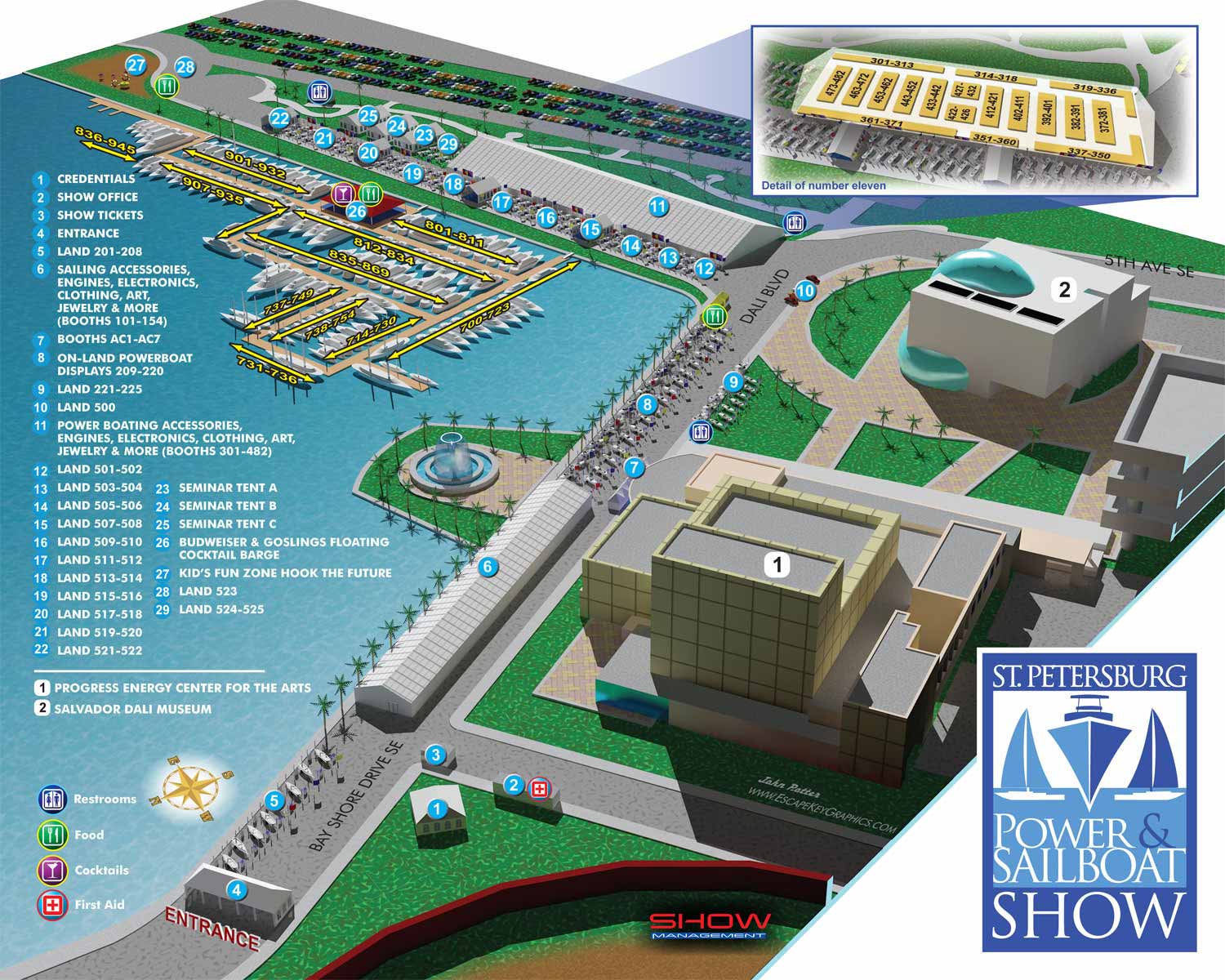
Building upon the foundation of the previous year's map for the St. Petersburg Power and Sailboat Show, the 2012 edition represented a significant technological and artistic evolution. Just one year after my initial design, I chose to completely reimagine the illustration process, moving from a two dimensional vector approach to constructing a full digital three dimensional model of the event area.
While the show's footprint remained largely consistent, forming an L shape along Bayshore Drive SE and Albert Whitted Park with its floating docks, the new methodology offered unparalleled creative control. The shift to 3D modeling allowed me to experiment with vantage points and camera angles to find the most aesthetically balanced and informationally clear composition for the page, a challenge with the show's specific layout.
This technique unlocked a new level of realistic and engaging detail. By utilizing the Kerythea rendering engine, I could accurately depict material textures, such as the reflective glass facades of the landmark Dalí Museum and Duke Energy Center for the Arts, and the translucent water of the Bayshore fountain. This year's map also featured detailed three dimensional boat models within the marina, contributing to a vibrant, tabletop diorama-like presentation that felt both relatable and immersive.
The proven keying system from the prior year was retained for its effectiveness. A color coded numerical system, with blue dots for show points of interest and white dots for general landmarks, provided clear navigation. Amenities were again indicated through an intuitive set of graphical icons, supported by a legend.
The final 2012 map achieved a notable harmony between function and form. It served as an excellent wayfinding tool for attendees, used in print, online, and on signage, while its artistic quality allowed it to function as a distinctive marketing piece for the event itself. In many ways, this edition represents a golden year for the map's aesthetic, offering a detailed and visually rich snapshot of the show before subsequent growth necessitated a broader, more simplified viewpoint. It stands as a testament to how advanced rendering techniques can elevate practical information design into a compelling visual asset.
St. Petersburg Power & Sailboat Show Maps
- About St. Petersburg Power & Sailboat Show
- 2026 | 2025 | 2024 | 2023 | 2022 | 2021 | 2019 | 2018 | 2017 | 2016 | 2015 | 2014 | 2013 | 2012 | 2011


EXPLORE MY PORTFOLIOS
- Illustration: Find custom illustration, book covers, illustrated maps, and architectural rendering.
- Fine Art: Browse original paintings and drawings, the Custom Halftone Series, and murals.
- Graphic Design & Motion: See my graphic design work, plus motion design and animated illustrations.
- Maps by industry: Illustrated maps tailored for boat shows, resorts, marinas, real estate, transit & parking, towns & cities, parks, and wayfinding.
- Other project types: Also available: cover art, vehicle & vinyl wraps, proposal renderings, and street art.
- Techniques: Explore work in vector, isometric & axonometric, painting, black & white, GeoData, overhead, and halftone styles.
- Software: Primary tools: Photoshop, Illustrator, SketchUp Pro, and InDesign. Motion work uses Premiere Pro & After Effects.