Illustrated Map for a Golfing Resort
Client: Soleil Spa
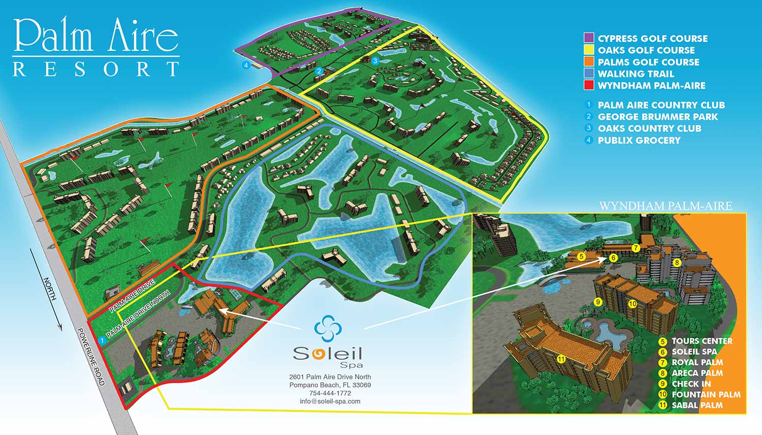
Soleil Spa commissioned Escape Key Graphics to create a custom illustrated map that clearly communicates its location within the Pal-Aire Resort while also showing its relationship to the surrounding golf courses. Because the property and nearby courses cover a large area, the solution was a two part map. The primary illustration provides a broad overview of the resort and adjacent golf courses, while a detailed inset map focuses specifically on the spa’s position within the resort itself. This approach allows viewers to quickly understand both the regional context and the exact on site location.
To ensure accuracy and visual clarity, a three dimensional model of the area was built in SketchUp and then refined through rendering and image adjustments in Adobe Photoshop. Final labeling and legends were completed in Adobe Illustrator for crisp, readable typography. A thoughtful color coding system was used to differentiate each golf course, along with a numbered key for points of interest. Locations within the spa’s resort area are identified with yellow numbering, while points outside the resort are marked in blue, helping viewers instantly distinguish between them.
An illustrated resort map like this does more than look attractive. It improves wayfinding and helps guests feel confident navigating a large or complex property. When visitors can easily see where a business is located in relation to parking, amenities, and nearby landmarks, they are far more likely to arrive relaxed and on time. Clear, professionally illustrated maps reduce confusion, improve the guest experience, and ultimately help bring more customers through the door.


GOLF RELATED ILLUSTRATED MAPS:


ABOUT RESORT MAPS:
Clear wayfinding is essential to a positive guest experience, and a well designed resort map plays a major role in making that possible. When guests can easily locate amenities, lodging, dining, and recreation without confusion, they enjoy their stay more and place fewer demands on staff for directions. A custom illustrated resort map provides an immediate visual overview of the property, helping guests orient themselves quickly while reinforcing the resort’s brand and atmosphere.
I have created custom resort maps for a wide range of destinations, from waterfront properties and resort marinas to locations well inland. These projects include rustic cabin resorts set in wooded environments, luxury spa destinations adjacent to golf courses, and mixed use resort properties with complex layouts. In addition to full property maps, I have also produced detailed illustrated floor plans showing the interior layouts of rental apartments and resort accommodations, allowing guests to understand spaces before they arrive.
Clients consistently report that these illustrated maps become one of the most useful tools they provide to guests. They reduce confusion, minimize the need for staff to give repeated directions, and help visitors feel confident navigating the property on their own. Whether used in print, signage, mobile apps, or websites, custom resort illustrated maps offer both practical value and visual appeal, making them an effective investment for resorts focused on guest satisfaction and operational efficiency.
PORTFOLIO GALLERIES
- Illustration work: Start with custom illustration and cover design, then view illustrated maps and architectural renderings.
- Fine art: Discover original paintings and drawings, the Custom Halftone Series, and mural projects.
- Design & motion: Check out the graphic design gallery, then move on to motion graphics and animated illustration.
- Maps by sector: I produce illustrated maps for boat shows, resorts, marinas, real estate, transit & parking, towns & cities, parks, and wayfinding systems.
- More creative services: Additional offerings include cover illustration, vehicle wraps, proposal renderings, and street art.
- Artistic methods: My work spans vector art, isometric & axonometric views, traditional painting, black & white illustration, GeoData mapping, overhead perspectives, and halftone effects.
- Preferred software: I rely on Photoshop, Illustrator, SketchUp Pro, and InDesign, plus Premiere Pro & After Effects for motion projects.