Mini Golf Illustrated Map
Client: Belgraphix
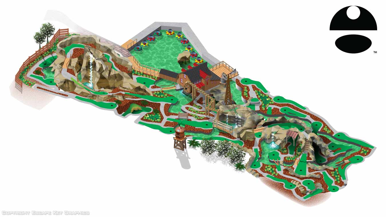
This golf course map is a sub-section of a larger map for a theme park in Massachusetts. I created this section map as a practical matter and not because the client requested it. By isolating this are as a separate, included file I kept my computer from bogging down while working on the overall map. I chose the miniature golf course as the area to isolate in this fashion because it was the most detail intensive area and therefore used the most RAM. The fact that it turned out to make this nice of a stand-alone piece of work was a little bit of a surprise to me.
This map was made isometrically (or axonometrically if you want to be picky) from a flat drawing all in Adobe Illustrator. I mostly use Sketchup for a more architectural look most of the time but my client liked this look. For the overall map I had worked mostly from aerial/satellite images and photos. I also had the opportunity to visit the site and shoot photos and collect GPS data which helped a lot.
The miniature golf course was so dense with detail in such a small area it would have been pretty intimidating but I was fortunate that the client did have a CAD drawing. This probably saved me many hours of drawing and redrawing to get everything scaled perfectly. Once I started making the transition from flat to isometric drawing I really got into flow state and had a great time solving problems like how to make a convincing waterfall in vector format. I used a rock rendering technique that I had originally worked out for Dinosaur World's maps.
This map turned out fun but it's also measurement accurate to what is on location. I see that the client is still using the map on their website and for signage years later. Visit them in Westford, MA.
Also related...


GOLF RELATED ILLUSTRATED MAPS:
EXPLORE MY PORTFOLIOS
- Illustration: Find custom illustration, book covers, illustrated maps, and architectural rendering.
- Fine Art: Browse original paintings and drawings, the Custom Halftone Series, and murals.
- Graphic Design & Motion: See my graphic design work, plus motion design and animated illustrations.
- Maps by industry: Illustrated maps tailored for boat shows, resorts, marinas, real estate, transit & parking, towns & cities, parks, and wayfinding.
- Other project types: Also available: cover art, vehicle & vinyl wraps, proposal renderings, and street art.
- Techniques: Explore work in vector, isometric & axonometric, painting, black & white, GeoData, overhead, and halftone styles.
- Software: Primary tools: Photoshop, Illustrator, SketchUp Pro, and InDesign. Motion work uses Premiere Pro & After Effects.