
Illustrated Plant City, FL Theme Park Map
Client: Dinosaur World
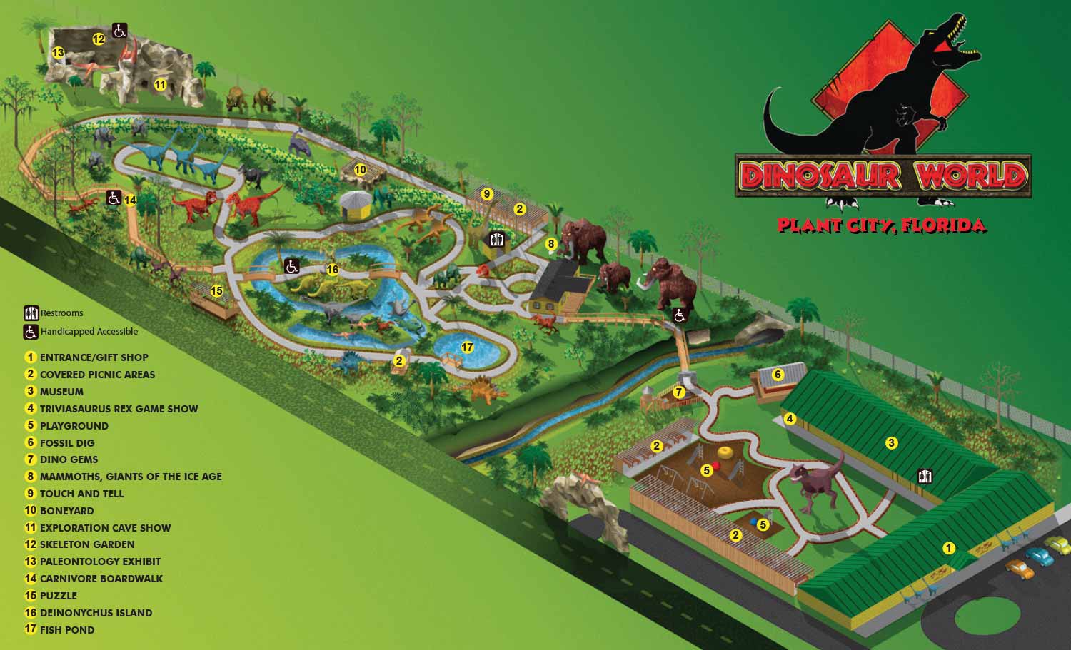

This map was originally created in 2011 and is one of my earlier maps. At the time I was making all maps as isometric drawings in Adobe Illustrator. The fun, quirky, kind of cartoon like look was perfect for this attraction. Dinosaur World has parks in Florida, Kentucky and Texas all featuring loads of life size dinosaur replicas in a natural setting and lots other amenities like playgrounds and a gift shop. I later created maps for the other venues using similar methods.
The theme park had no map when they contracted me and no CAD drawings or site plan. The tree canopy was pretty thick so satellite and/or aerial photography wasn't very helpful. I resolved this problem the same way I had made the Flamingo Gardens map, by using GPS to map the paths. I also shot lots of photography including panoramic photos (which I was doing at the time). GPS and panoramic photography were pretty high tech by 2011 standards but if the same project came across my desk today I would still handle it similarly. Today I might be able to talk someone through this data collection process, but it's probably inadvisable. In 2011 phones didn't have GPS and Garmin products weren't cheap so working on location was a necessity.
Using the GPS data I made Google My Maps to draw the paths as well as the positions of the dinosaurs and buildings so that I could have that all verified as correct with the client before proceeding on map creation. I still use this technique from time to time now.
Maps like this can take several layers as the geometry becomes too complex and my computer bogs down. Once a layer becomes too complex I convert the vector file to a flat bitmap. I then place it in a new file with the same proportions in Illustrator and continue adding more details, buildings or whatever is needed as vector art. Once the illustration part is complete I flatten the whole thing to a flat bitmap, place it in a new file of with the same proportions in Illustrator and create the keying and labeling etc.. This will become final files for the client so that they can make minor revisions in house. Changes to the illustration would require my intervention. I also provide files in web friendly formats (JPG and PDF).
Dinosaur World uses this map and the ones for their other parks as handouts to guests, as signage and on their website. As I mentioned, I have made revisions over the years as Dinosaur World's parks grows and expand.
Also see maps for Dinosaur World FL | Dinosaur World KY | Dinosaur World TX


WHAT ARE AXONOMETRIC AND ISOMETRIC ILLUSTRATIONS?:
Axonometric and isometric drawings don’t have realistic perspective. I use specific mathematical formulas to draw this way. In these images things further away don’t appear smaller and therefore have equal weight of importance to things nearby. My axonometric maps and illustrations are generally bold and have a slightly cartoon like look. This method of rendering perspective is commonly used in technical and engineering drawings. I began using this method of drawing as an illustration tool in 2007.
The difference between isometric and axonometric is isometric drawings are really just from a straight on corner angle but axonometric drawings can be from other angles. Most of my illustrations have parts that are isometric, but are largely axonometric. I have a habit of calling them all isometric, but I shouldn't.
BROWSE MY WORK
- Illustration: Browse custom illustrations, book cover art, illustrated maps, and architectural renderings.
- Fine art: View original paintings and drawings, the Custom Halftone Series, and mural commissions.
- Graphic design & motion: See design projects, then watch motion reels and animated pieces.
- Maps by use case: Explore illustrated maps created for boat shows, resorts, marinas, real estate, transportation & parking, cities & towns, parks, and wayfinding.
- Specialty projects: Also check out cover design, vinyl & vehicle wraps, proposal renderings, and street art.
- Style & technique: Discover vector, isometric, painterly, monochrome, data-driven, bird's-eye, and halftone approaches.
- Tools I use: Everyday software includes Photoshop, Illustrator, SketchUp, and InDesign; motion work relies on Premiere & After Effects. Recently I have begun some work using AI as well.