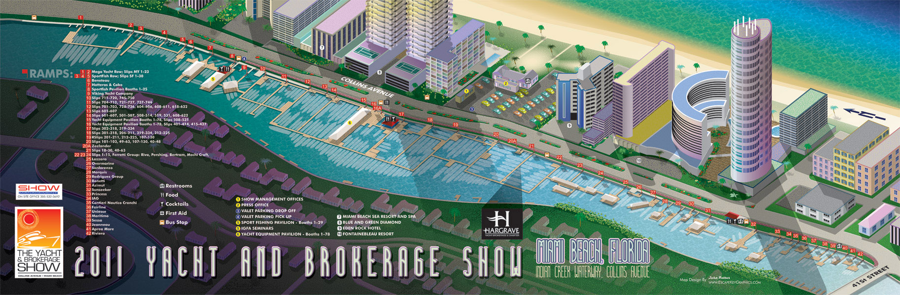
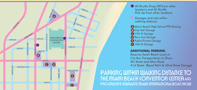
Yacht Show Illustrated Guide Map
Client: Show Management
Miami International Boat Show:
I have worked on illustrated maps and wayfinding graphics for the Miami International Boat Show (also known as MIBS) for many years, supporting one of the largest and most complex boat shows in the world. The show spans multiple waterfront venues across Miami and Miami Beach, including convention spaces, marinas, and on water exhibition areas. This scale presents unique challenges, and clear navigation is essential for both visitors and exhibitors. My role has been to translate that complexity into maps that are easy to understand while still feeling polished, professional, and appropriate for a premier international event.
Each year the Miami International Boat Show evolves. Dock layouts shift, exhibitor locations change, venues are added or removed, and sponsorship requirements are updated. I routinely revise and rebuild maps to reflect these changes accurately, often under tight deadlines. My approach emphasizes a strong visual hierarchy that allows guests to orient themselves quickly, identify major zones, and then locate specific docks, tents, amenities, and points of interest. This clarity helps reduce confusion and improves the overall guest experience across all show locations.
The illustrated maps I create for the Miami International Boat Show are used in a wide range of formats, including print programs, signage, exhibitor materials, and digital platforms. I rely on consistent systems such as numbered keying for primary destinations and icon based symbols for recurring amenities like restrooms, food areas, transportation, and services. This method minimizes visual clutter and ensures that information remains legible even in dense, information rich environments.
Large scale marine events like the Miami International Boat Show require a careful balance between accuracy, usability, and visual appeal. My experience with boat shows, marinas, and waterfront venues allows me to design maps that serve practical navigation needs while also reinforcing the upscale branding of the event. For organizers, sponsors, and exhibitors, a well designed illustrated map becomes an essential tool that supports crowd flow, improves communication, and enhances the overall perception of the show.
Which Miami Boat Show is this?:
Here is all you need to know... I have been making maps for boat shows in Miami since 2011 and in that time a lot has changed. There have been multiple simultaneous shows, show names have changed and now shows have merged. The assorted show titles used have been Miami International Boat Show, Miami Yacht Show, Yachts Miami Beach, Miami Beach Yacht and Brokerage Show and this doesn't include subsections of the shows like Sea Isle Marina, Museum Park Marina and Strictly Sail Miami at Miamarina Bayside. These shows have been managed by different, sometimes competing, management companies. At some point I have been commissioned to make maps for all of them. I'm not going to try to sort this into a comprehensible timeline or anything like that.
I've endeavored to make the maps easy to find but you may find some hidden gems on my site if you dig. Please enjoy these maps for what they are without getting too distracted by the sequence or sponsors/management companies etc.
EXAMPLES OF MAPS CREATED FOR MIAMI BOAT SHOWS:


Maps For Boat Shows In Miami:
- About Miami Boat Shows
- Miami International Boat Show / Miami Yacht Show / Yachts Miami Beach / Miami Beach Yacht and Brokerage Show - Show Center/Primary Venue Maps: 2026 | 2025 | 2024 | 2023 | 2022 | 2020 | 2019 | 2018 | 2017 | 2016 | 2015 | 2014 | 2013 | 2012 | 2011
- Transportation Map: 2026 | 2025 | 2024 | 2023 | 2022 | 2020 | 2019 | 2016 | 2013 | 2012
- Program Layout: 2026 | 2025 | 2024 | 2023 | 2022
- Yacht Haven Grande at Island Gardens: 2026 | 2022 | 2020 | 2016
- Miami Beach Convention Center: 2026 | 2025 | 2024 | 2023 | 2022 | 2013 | 2012
- Sea Isle Marina Only: 2013 | 2012
- Miamarina at Bayside Only: 2013 | 2012 | 2011
- Bayfront Park: 2015
- Museum Park Marina: 2025 | 2024 | 2023 | 2022
- Illustration (not a map): 2014
- Video: 2013
Miami International Boat Show Maps 2013:
Miami Beach Convention Center Map | New Yacht & Power Boat Show at Sea Isle MarinaStrictly Sail Miami at Miamarina Bayside | Miami International Boat Show Transit | Miami Beach Convention Center Parking


WHAT ARE AXONOMETRIC AND ISOMETRIC ILLUSTRATIONS?:
Axonometric and isometric drawings don’t have realistic perspective. I use specific mathematical formulas to draw this way. In these images things further away don’t appear smaller and therefore have equal weight of importance to things nearby. My axonometric maps and illustrations are generally bold and have a slightly cartoon like look. This method of rendering perspective is commonly used in technical and engineering drawings. I began using this method of drawing as an illustration tool in 2007.
The difference between isometric and axonometric is isometric drawings are really just from a straight on corner angle but axonometric drawings can be from other angles. Most of my illustrations have parts that are isometric, but are largely axonometric. I have a habit of calling them all isometric, but I shouldn't.
PORTFOLIO SELECTIONS
- Custom illustration & covers: Featuring bespoke illustration, book and magazine covers, hand-drawn maps, and building renderings.
- Fine art & murals: Including one-of-a-kind paintings and drawings, the Custom Halftone Series, and large-scale murals.
- Design & motion media: Covering graphic design, plus video and motion and animated illustration.
- Mapping by application: Tailored maps for marine events, hospitality, waterfront, property, transit, municipal, recreation, and navigation needs.
- Additional creative work: Includes editorial covers, vehicle graphics, concept renderings, and public art.
- Mediums & formats: Ranging from digital vector and isometric projection to traditional paint, line art, GIS-based, aerial-style, and halftone.
- Software expertise: Proficient in Photoshop, Illustrator, SketchUp, InDesign, and Premiere/After Effects for motion.