Site Plan For a Boat Show in Miami as an Illustrated Map
Client: Informa Markets
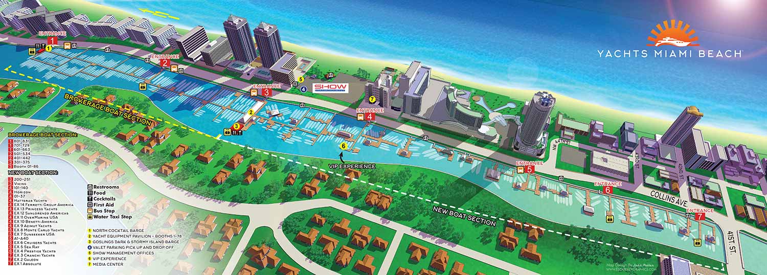
This Miami Beach map was the result of modification of the existing digital model created for previous years' show. For 2017 I increased saturation throughout and added a sunspot or sundog in the upper righthand corner.
The map remained more pragmatic than stylish as was established in the previous year. The map was designed as a wide foldout piece for print use. The surrounding neighborhood rendered in this map remains largely unchanged, making the map a lasting visual record of the location and a resource I can return to if needed.
Wayfinding was handled through a same clear and organized system that had proven reliable in previous years but a section divider for new and brokerage boat sections was added. Ramps were keyed using numbered red rectangles, while additional points of interest were marked with colored, numbered dots. Recurring amenities were represented with simple icons for easy recognition. The three dimensional model was created in SketchUp Pro, refined in Adobe Photoshop, and completed with final layout and graphic elements in Adobe Illustrator. The map was integrated into the program using Adobe InDesign.
This is one of several maps I created for this show.
Maps For Boat Shows In Miami:
- About Miami Boat Shows
- Miami International Boat Show / Miami Yacht Show / Yachts Miami Beach / Miami Beach Yacht and Brokerage Show - Show Center/Primary Venue Maps: 2026 | 2025 | 2024 | 2023 | 2022 | 2020 | 2019 | 2018 | 2017 | 2016 | 2015 | 2014 | 2013 | 2012 | 2011
- Transportation Map: 2026 | 2025 | 2024 | 2023 | 2022 | 2020 | 2019 | 2016 | 2013 | 2012
- Program Layout: 2026 | 2025 | 2024 | 2023 | 2022
- Yacht Haven Grande at Island Gardens: 2026 | 2022 | 2020 | 2016
- Miami Beach Convention Center: 2026 | 2025 | 2024 | 2023 | 2022 | 2013 | 2012
- Sea Isle Marina Only: 2013 | 2012
- Miamarina at Bayside Only: 2013 | 2012 | 2011
- Bayfront Park: 2015
- Museum Park Marina: 2025 | 2024 | 2023 | 2022
- Illustration (not a map): 2014
- Video: 2013
Which Miami Boat Show is this?:
Here is all you need to know... I have been making maps for boat shows in Miami since 2011 and in that time a lot has changed. There have been multiple simultaneous shows, show names have changed and now shows have merged. The assorted show titles used have been Miami International Boat Show, Miami Yacht Show, Yachts Miami Beach, Miami Beach Yacht and Brokerage Show and this doesn't include subsections of the shows like Sea Isle Marina, Museum Park Marina and Strictly Sail Miami at Miamarina Bayside. These shows have been managed by different, sometimes competing, management companies. At some point I have been commissioned to make maps for all of them. I'm not going to try to sort this into a comprehensible timeline or anything like that.
I've endeavored to make the maps easy to find but you may find some hidden gems on my site if you dig. Please enjoy these maps for what they are without getting too distracted by the sequence or sponsors/management companies etc.
As of 2026 what might be colloquially referred to as The Miami Boat Show is consolidated under one management company, being Informa, and the official name of the show is The Miami International Boat Show. The upcoming show will have five venues at three geographic locations. Those locations will be "Yacht Collection" at 16 Collins Avenue, Miami Beach, "Convention Center" and "Boat Show Experience" at Miami Beach Convention Center and Pride Park in Miami Beach and "Superyacht Miami" and "Sailor's Cove" at IGY Yacht Haven Grande Miami, 18th St & Purdy Avenue. I will be posting those maps son as the show is growing close now.
Miami International Boat Show:
I have worked on illustrated maps and wayfinding graphics for the Miami International Boat Show (also known as MIBS) for many years, supporting one of the largest and most complex boat shows in the world. The show spans multiple waterfront venues across Miami and Miami Beach, including convention spaces, marinas, and on water exhibition areas. This scale presents unique challenges, and clear navigation is essential for both visitors and exhibitors. My role has been to translate that complexity into maps that are easy to understand while still feeling polished, professional, and appropriate for a premier international event.
Each year the Miami International Boat Show evolves. Dock layouts shift, exhibitor locations change, venues are added or removed, and sponsorship requirements are updated. I routinely revise and rebuild maps to reflect these changes accurately, often under tight deadlines. My approach emphasizes a strong visual hierarchy that allows guests to orient themselves quickly, identify major zones, and then locate specific docks, tents, amenities, and points of interest. This clarity helps reduce confusion and improves the overall guest experience across all show locations.
The illustrated maps I create for the Miami International Boat Show are used in a wide range of formats, including print programs, signage, exhibitor materials, and digital platforms. I rely on consistent systems such as numbered keying for primary destinations and icon based symbols for recurring amenities like restrooms, food areas, transportation, and services. This method minimizes visual clutter and ensures that information remains legible even in dense, information rich environments.
Large scale marine events like the Miami International Boat Show require a careful balance between accuracy, usability, and visual appeal. My experience with boat shows, marinas, and waterfront venues allows me to design maps that serve practical navigation needs while also reinforcing the upscale branding of the event. For organizers, sponsors, and exhibitors, a well designed illustrated map becomes an essential tool that supports crowd flow, improves communication, and enhances the overall perception of the show.
EXAMPLES OF MAPS CREATED FOR MIAMI BOAT SHOWS:


