An intricate transportation map showing multiple transportation means to multiple event venues - 2013
Client: National Marine Manufacturers Association
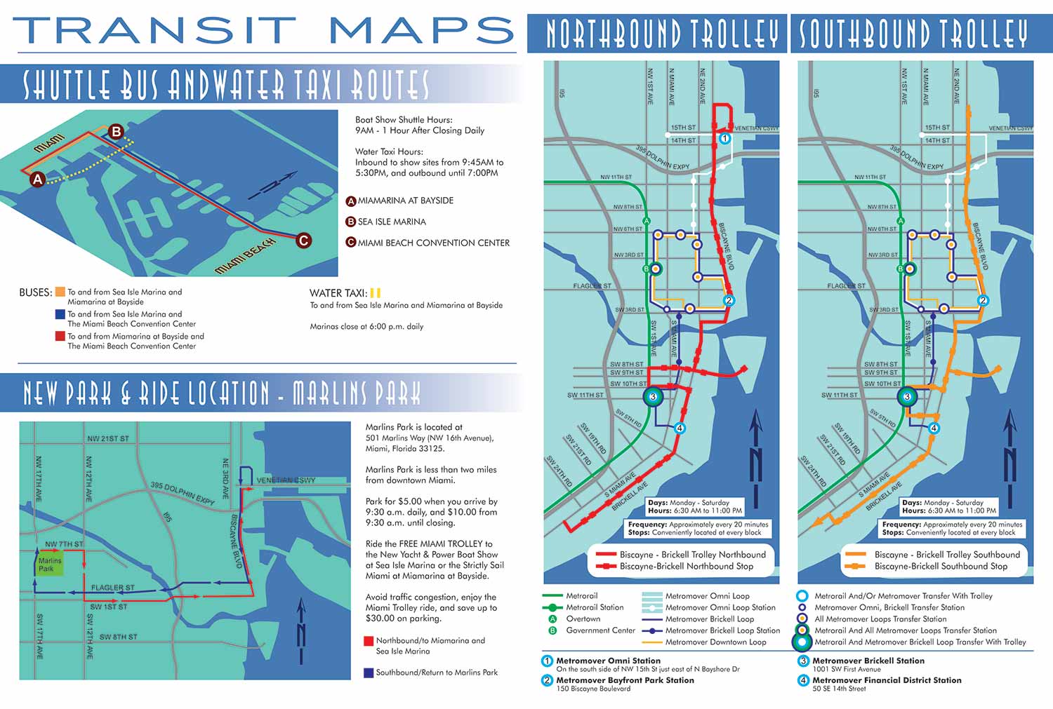

These vector based transit maps were created in 2013 for major boat shows in Miami and were designed to support clear, reliable wayfinding across a complex urban transportation network. The project includes a compact isometric map that illustrates color coded routes connecting venues in Miami and Miami Beach. A simple lettered key system allows users to quickly understand route relationships and destination groupings at a glance.
Below that is a clean overhead street map focused on a park and ride system serving the Miami area. This map uses a straightforward, top down perspective with color coded routes to clearly communicate how visitors could move between parking locations and event venues. The restrained design keeps the focus on transportation flow rather than decorative detail.
The most complex pieces in this set are the two trolley maps shown on the right. One illustrates the northbound trolley route with stops and the other the southbound route with stops. Both maps share the same detailed street base, which includes a high density of street names while remaining readable and well organized. Land and water are each represented by a single flat color to reduce visual noise. Four primary trolley stops are highlighted on both maps using numbered markers, with the trolley routes themselves clearly distinguished by color.
Beyond the trolley system, these maps also integrate multiple layers of Miami public transportation. The Miami Metrorail line and its stations are included and identified with lettered markers. Three separate Miami Metromover routes are shown, along with their stops and transfer stations. Transfer points between Metrorail and Metromover are clearly identified, as are stations that serve as transfers between specific routes. Service frequency and schedule information are also incorporated directly into the maps, adding another level of detail for users planning their trips.
While these maps successfully met the client’s requirements, they are intentionally dense and demand focused attention from the viewer. From a design perspective, the information could have been distributed across additional maps or simplified to reduce cognitive load. Even so, the maps function effectively as comprehensive references. For users willing to spend time studying them, all necessary information is present in a single, coordinated visual system. All artwork was produced as scalable vector graphics, ensuring clarity, consistency, and flexibility across print and digital applications.
Which Miami Boat Show is this?:
Here is all you need to know... I have been making maps for boat shows in Miami since 2011 and in that time a lot has changed. There have been multiple simultaneous shows, show names have changed and now shows have merged. The assorted show titles used have been Miami International Boat Show, Miami Yacht Show, Yachts Miami Beach, Miami Beach Yacht and Brokerage Show and this doesn't include subsections of the shows like Sea Isle Marina, Museum Park Marina and Strictly Sail Miami at Miamarina Bayside. These shows have been managed by different, sometimes competing, management companies. At some point I have been commissioned to make maps for all of them. I'm not going to try to sort this into a comprehensible timeline or anything like that.
I've endeavored to make the maps easy to find but you may find some hidden gems on my site if you dig. Please enjoy these maps for what they are without getting too distracted by the sequence or sponsors/management companies etc.
EXAMPLES OF MAPS CREATED FOR MIAMI BOAT SHOWS:


Maps For Boat Shows In Miami:
- About Miami Boat Shows
- Miami International Boat Show / Miami Yacht Show / Yachts Miami Beach / Miami Beach Yacht and Brokerage Show - Show Center/Primary Venue Maps: 2026 | 2025 | 2024 | 2023 | 2022 | 2020 | 2019 | 2018 | 2017 | 2016 | 2015 | 2014 | 2013 | 2012 | 2011
- Transportation Map: 2026 | 2025 | 2024 | 2023 | 2022 | 2020 | 2019 | 2016 | 2013 | 2012
- Program Layout: 2026 | 2025 | 2024 | 2023 | 2022
- Yacht Haven Grande at Island Gardens: 2026 | 2022 | 2020 | 2016
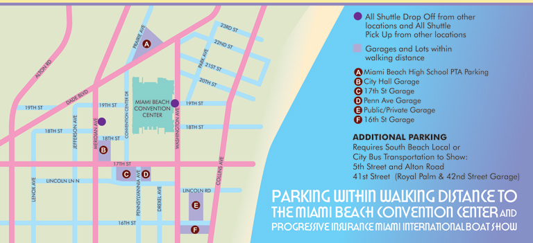
- Miami Beach Convention Center: 2026 | 2025 | 2024 | 2023 | 2022 | 2013 | 2012
- Sea Isle Marina Only: 2013 | 2012
- Miamarina at Bayside Only: 2013 | 2012 | 2011
- Bayfront Park: 2015
- Museum Park Marina: 2025 | 2024 | 2023 | 2022
- Illustration (not a map): 2014
- Video: 2013
Miami International Boat Show Maps 2013:
Miami Beach Convention Center Map | New Yacht & Power Boat Show at Sea Isle MarinaStrictly Sail Miami at Miamarina Bayside | Miami International Boat Show Transit | Miami Beach Convention Center Parking


TRANSIT, PARKING AND TRANSPORTATION MAPS:
These maps are often presented from a direct overhead perspective, giving them a familiar appearance similar to the street maps many people use in their cars. Accuracy, clarity, and selective emphasis are essential, as these maps are frequently used in real time, often while navigating busy streets or parking areas. I tailor the level of detail to each client's needs, including only the elements that are most useful for users, ensuring that finding the right location is always intuitive and straightforward.
In many recent projects, I have incorporated geospatial data to produce maps in a more conventional cartographic style. Complex sites with dense street networks, multiple access points, or high volumes of features require reliable external data sources to ensure efficiency and accuracy. Even when using this data, I apply my own illustrative approach to enhance readability, highlight key locations, and maintain a consistent visual identity that aligns with the client's goals.
There are also cases where a three-dimensional perspective is advantageous. A 3D view can provide a more realistic understanding of a site, helping viewers visualize parking areas, transit hubs, and landmarks in context. In locations dominated by prominent features or architectural highlights, this perspective can make orientation easier and offer users a more immersive, intuitive experience than a standard overhead view.
Whether presented in 2D or 3D, these maps are designed to simplify navigation, improve user confidence, and support the operational and marketing goals of transportation, parking, and transit organizations. By combining precision, clarity, and visual appeal, they provide an essential tool for both staff and visitors.
PORTFOLIO GALLERIES
- Illustration work: Start with custom illustration and cover design, then view illustrated maps and architectural renderings.
- Fine art: Discover original paintings and drawings, the Custom Halftone Series, and mural projects.
- Design & motion: Check out the graphic design gallery, then move on to motion graphics and animated illustration.
- Maps by sector: I produce illustrated maps for boat shows, resorts, marinas, real estate, transit & parking, towns & cities, parks, and wayfinding systems.
- More creative services: Additional offerings include cover illustration, vehicle wraps, proposal renderings, and street art.
- Artistic methods: My work spans vector art, isometric & axonometric views, traditional painting, black & white illustration, GeoData mapping, overhead perspectives, and halftone effects.
- Preferred software: I rely on Photoshop, Illustrator, SketchUp Pro, and InDesign, plus Premiere Pro & After Effects for motion projects.