Miami Beach Convention Center Map - 2012
Client: National Marine Manufacturers Association
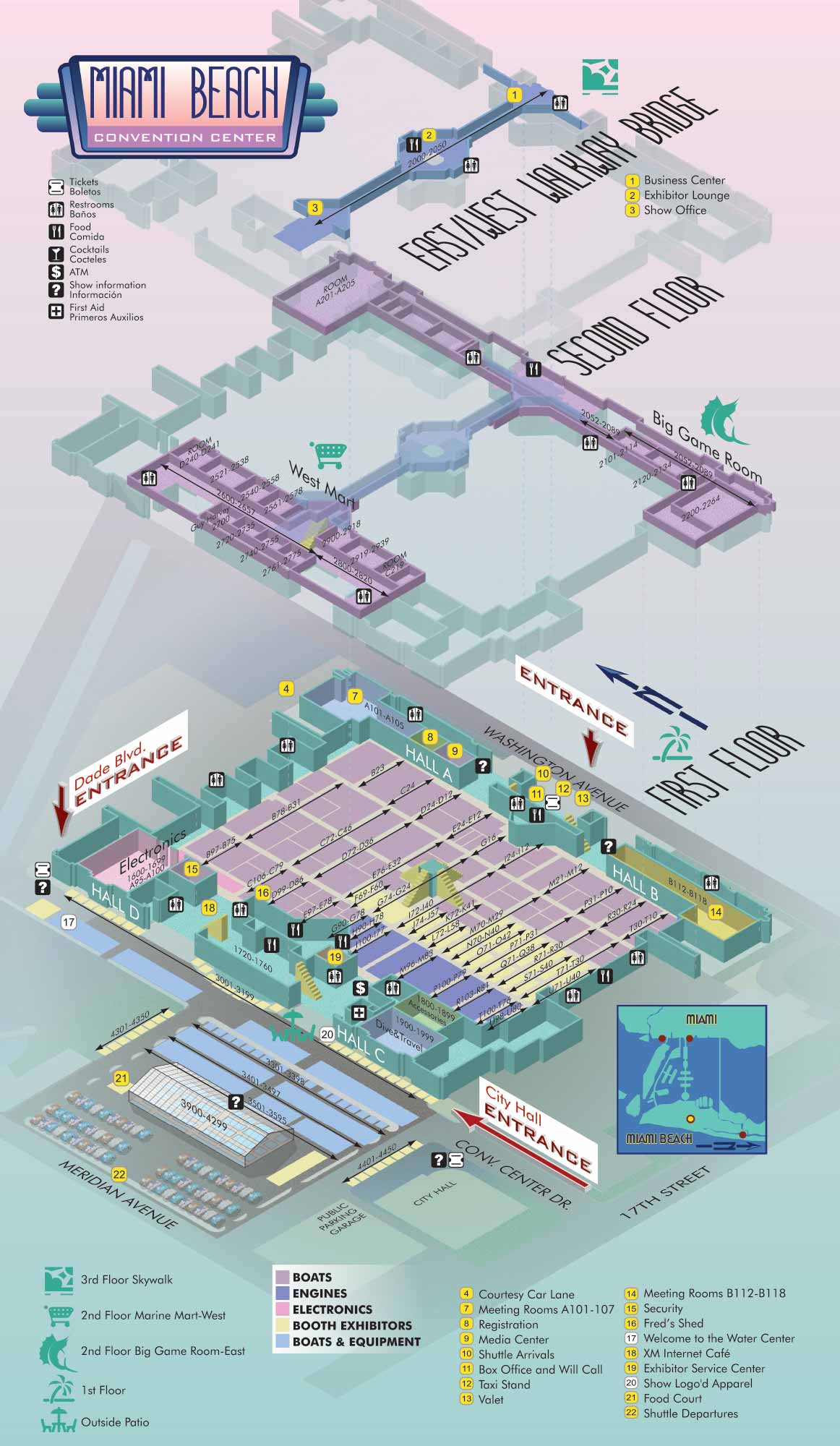
This vector based map was designed to assist visitors in navigating the Miami Beach Convention Center, helping them locate exhibitors, vendors, and essential services across multiple levels of the venue.
To clearly represent the building’s multi floor layout, the convention center is illustrated using an axonometric drawing style. This technique allows the simultaneous display of each floor while preserving accurate scale and spatial relationships. All artwork is fully vector based and employs a color palette inspired by Miami’s regional character. This approach maintains a local and approachable feel without compromising functional clarity.
The building is depicted as three aligned layers, with each layer representing a different floor. Because these layers share the same footprint and align precisely, users can easily understand how spaces connect both vertically and horizontally throughout the structure.
Key locations inside the venue are identified through a numbered map legend that corresponds directly with the official exhibitor directory. Exhibitor categories are distinguished by color coding to create recognizable zones that mirror the actual organization of the show floor. Booth numbers are placed directly on the map, with larger exhibitor spaces shown as labeled spans where needed. Essential amenities such as restrooms, information desks, and dining areas are marked with a consistent set of black and white icons. Major destinations and shared public areas are highlighted with larger, full color symbols for added emphasis.
This map provides a clear, organized, and visually engaging wayfinding system. This system improves the onsite experience for attendees while supporting the operational and logistical demands of a large scale event.
For more examples of my venue maps and illustration work, please visit my Maps Portfolio.
EXAMPLES OF MAPS CREATED FOR MIAMI BOAT SHOWS:


Maps For Boat Shows In Miami:
- About Miami Boat Shows
- Miami International Boat Show / Miami Yacht Show / Yachts Miami Beach / Miami Beach Yacht and Brokerage Show - Show Center/Primary Venue Maps: 2026 | 2025 | 2024 | 2023 | 2022 | 2020 | 2019 | 2018 | 2017 | 2016 | 2015 | 2014 | 2013 | 2012 | 2011
- Transportation Map: 2026 | 2025 | 2024 | 2023 | 2022 | 2020 | 2019 | 2016 | 2013 | 2012
- Program Layout: 2026 | 2025 | 2024 | 2023 | 2022
- Yacht Haven Grande at Island Gardens: 2026 | 2022 | 2020 | 2016
- Miami Beach Convention Center: 2026 | 2025 | 2024 | 2023 | 2022 | 2013 | 2012
- Sea Isle Marina Only: 2013 | 2012
- Miamarina at Bayside Only: 2013 | 2012 | 2011
- Bayfront Park: 2015
- Museum Park Marina: 2025 | 2024 | 2023 | 2022
- Illustration (not a map): 2014
- Video: 2013
Miami International Boat Show Maps 2012:
Miami Beach Convention Center Map | Bayside Map | Sea Isle Marina MapYacht and Brokerage Show Parking and Shuttles


