Marina Illustrated Map
Client: National Marine Manufacturers Association
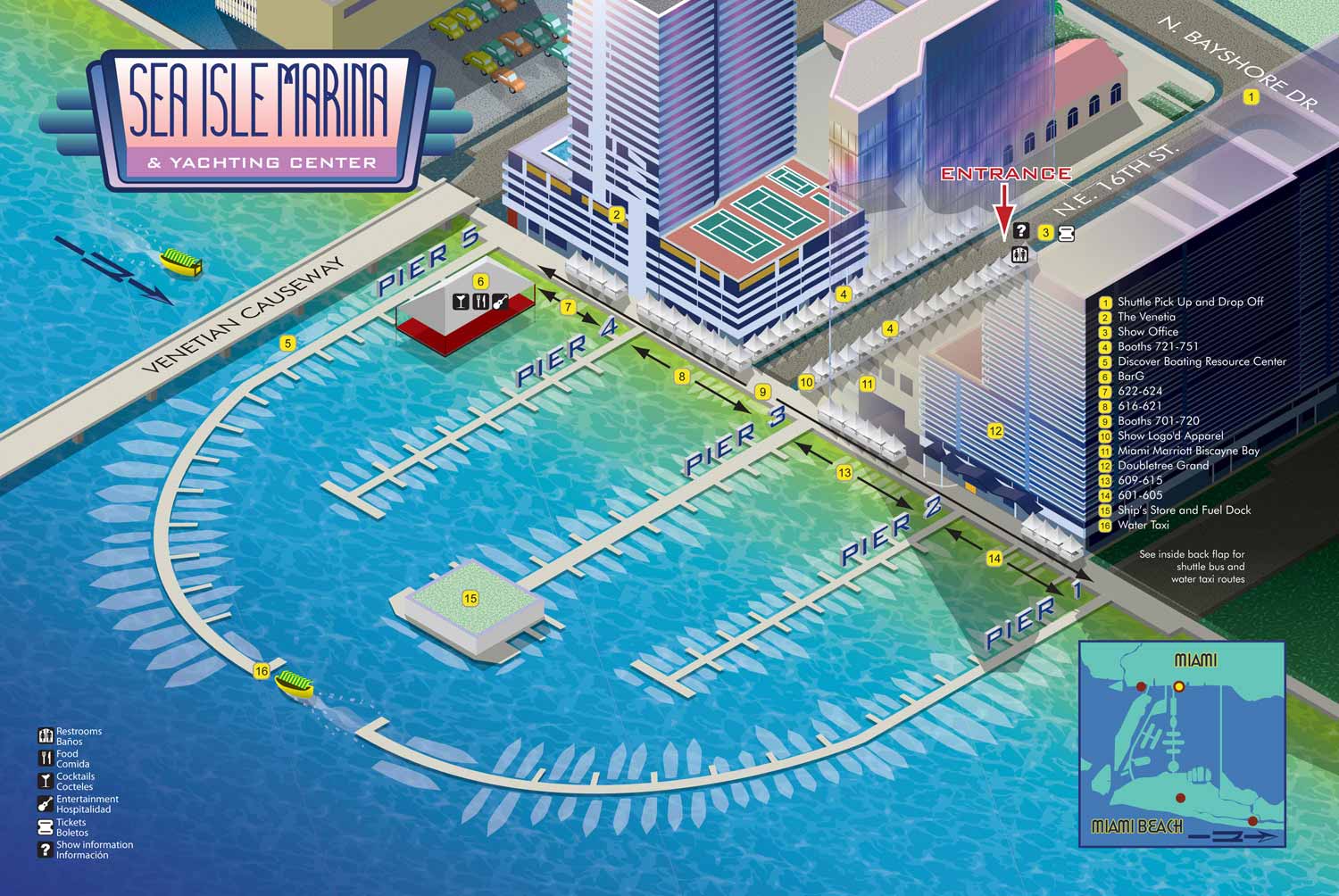
This illustrated map was created for the 2012 New Yacht and Powerboat Show, highlighting Sea Isle Marina at 1635 North Bayshore Drive, located at the mainland end of the Venetian Causeway in Miami. The map was designed to help visitors navigate the event while capturing the distinctive character and energy of this waterfront venue, which serves as a central access point for the show.
The illustration was produced entirely in vector format using an axonometric approach, allowing depth and structure to be conveyed without relying on traditional perspective. A vibrant, Miami inspired color palette was selected to reflect the lively atmosphere of both the location and the event itself.
Wayfinding elements were thoughtfully incorporated to ensure clarity for attendees. Key locations were marked with numbered yellow indicators, docks were illustrated as three dimensional axonometric forms, and street names were positioned to appear as if painted directly on the roadway. Recurring amenities were represented with clear icons for easy recognition, while an inset map provided context by showing Sea Isle Marina’s relationship to other show venues. This map reflects an early period in which Art Deco influences strongly informed the visual style, resulting in a distinctive and memorable guide for visitors.
Which Miami Boat Show is this?:
Here is all you need to know... I have been making maps for boat shows in Miami since 2011 and in that time a lot has changed. There have been multiple simultaneous shows, show names have changed and now shows have merged. The assorted show titles used have been Miami International Boat Show, Miami Yacht Show, Yachts Miami Beach, Miami Beach Yacht and Brokerage Show and this doesn't include subsections of the shows like Sea Isle Marina, Museum Park Marina and Strictly Sail Miami at Miamarina Bayside. These shows have been managed by different, sometimes competing, management companies. At some point I have been commissioned to make maps for all of them. I'm not going to try to sort this into a comprehensible timeline or anything like that.
I've endeavored to make the maps easy to find but you may find some hidden gems on my site if you dig. Please enjoy these maps for what they are without getting too distracted by the sequence or sponsors/management companies etc.
EXAMPLES OF MAPS CREATED FOR MIAMI BOAT SHOWS:


Maps For Boat Shows In Miami:
- About Miami Boat Shows
- Miami International Boat Show / Miami Yacht Show / Yachts Miami Beach / Miami Beach Yacht and Brokerage Show - Show Center/Primary Venue Maps: 2026 | 2025 | 2024 | 2023 | 2022 | 2020 | 2019 | 2018 | 2017 | 2016 | 2015 | 2014 | 2013 | 2012 | 2011
- Transportation Map: 2026 | 2025 | 2024 | 2023 | 2022 | 2020 | 2019 | 2016 | 2013 | 2012
- Program Layout: 2026 | 2025 | 2024 | 2023 | 2022
- Yacht Haven Grande at Island Gardens: 2026 | 2022 | 2020 | 2016
- Miami Beach Convention Center: 2026 | 2025 | 2024 | 2023 | 2022 | 2013 | 2012
- Sea Isle Marina Only: 2013 | 2012
- Miamarina at Bayside Only: 2013 | 2012 | 2011
- Bayfront Park: 2015
- Museum Park Marina: 2025 | 2024 | 2023 | 2022
- Illustration (not a map): 2014
- Video: 2013
Miami International Boat Show Maps 2012:
Miami Beach Convention Center Map | Bayside Map | Sea Isle Marina MapYacht and Brokerage Show Parking and Shuttles


PORTFOLIO GALLERIES
- Illustration work: Start with custom illustration and cover design, then view illustrated maps and architectural renderings.
- Fine art: Discover original paintings and drawings, the Custom Halftone Series, and mural projects.
- Design & motion: Check out the graphic design gallery, then move on to motion graphics and animated illustration.
- Maps by sector: I produce illustrated maps for boat shows, resorts, marinas, real estate, transit & parking, towns & cities, parks, and wayfinding systems.
- More creative services: Additional offerings include cover illustration, vehicle wraps, proposal renderings, and street art.
- Artistic methods: My work spans vector art, isometric & axonometric views, traditional painting, black & white illustration, GeoData mapping, overhead perspectives, and halftone effects.
- Preferred software: I rely on Photoshop, Illustrator, SketchUp Pro, and InDesign, plus Premiere Pro & After Effects for motion projects.