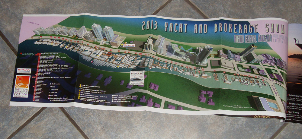
Miami Yacht and Brokerage Show Map - 2013
Miami Yacht and Brokerage Show Map - 2013
Illustrated Miami Beach Map
Artist, Illustrator, Designer: John Potter - Escape Key Graphics
Client: Show Management
Map in program
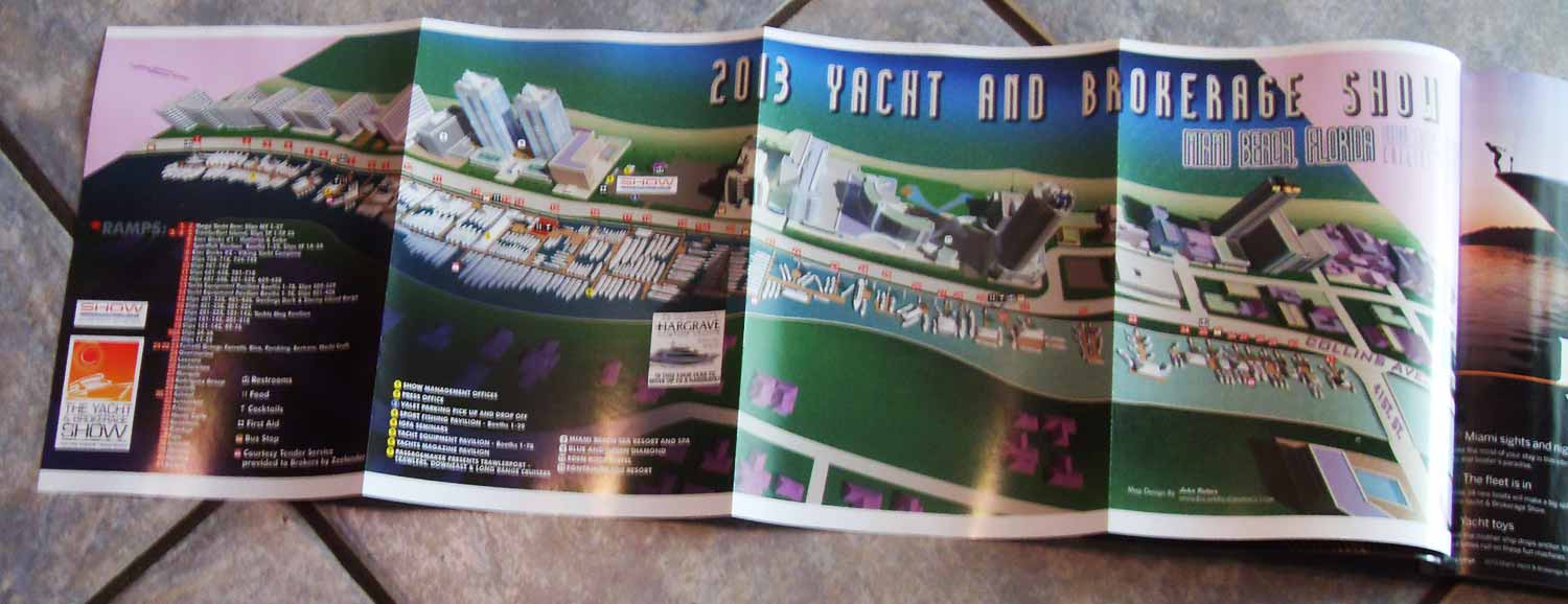
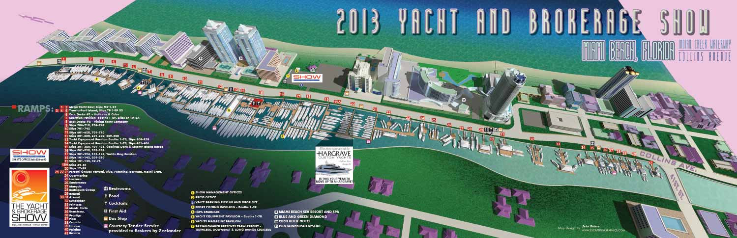
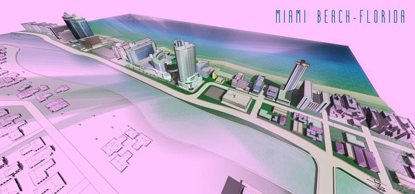
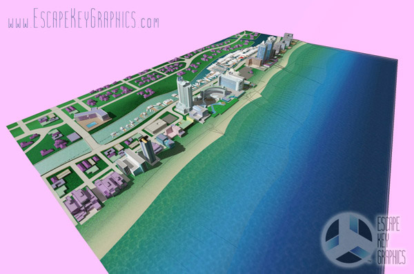
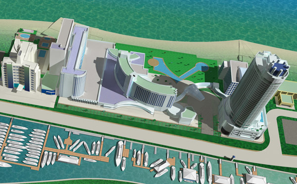
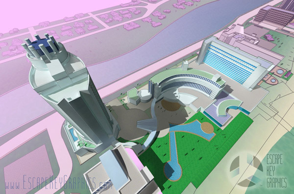
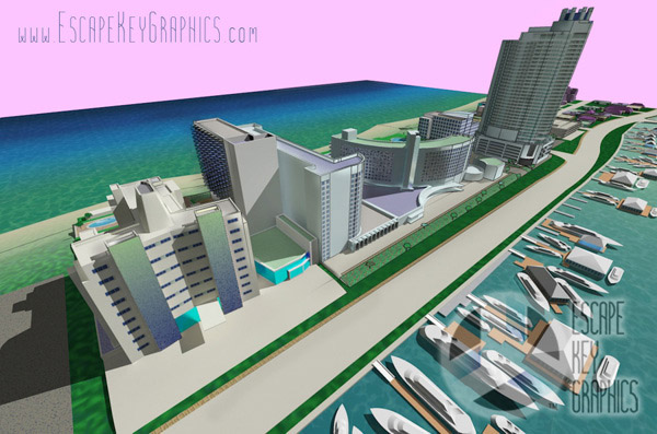
This Miami Beach map was one of the early digital model based illustrated maps created by Escape Key Graphics and reflects an important stage in the development of the studio’s visual style. The map was built as a virtual model with a defined outer edge, giving it the appearance of a tabletop display. While this presentation approach was later refined in response to client preferences, it remains a strong example of early 3D mapping techniques and creative experimentation.
The illustration features a distinctly Miami inspired color palette with soft pastels that reflect the character and energy of the area. At the time of production, the map was designed as a wide foldout piece for print use. Although the boat shows no longer use this specific venue, the surrounding neighborhood remains largely unchanged, making the map a lasting visual record of the location.
Wayfinding was handled through a clear and organized system. Ramps were identified using numbered red rectangles, while additional points of interest were marked with colored, numbered dots. Recurring amenities were represented with simple icons for easy recognition. The three dimensional model was created in SketchUp Pro, rendered in Kerkythea, refined in Adobe Photoshop, and completed with final layout and graphic elements in Adobe Illustrator. This project demonstrates an early but thoughtful approach to combining illustration, accuracy, and practical navigation.
Here is all you need to know... I have been making maps for boat shows in Miami since 2011 and in that time a lot has changed. There have been multiple simultaneous shows, show names have changed and now shows have merged. The assorted show titles used have been Miami International Boat Show, Miami Yacht Show, Yachts Miami Beach, Miami Beach Yacht and Brokerage Show and this doesn't include subsections of the shows like Sea Isle Marina, Museum Park Marina and Strictly Sail Miami at Miamarina Bayside. These shows have been managed by different, sometimes competing, management companies. At some point I have been commissioned to make maps for all of them. I'm not going to try to sort this into a comprehensible timeline or anything like that.
I've endeavored to make the maps easy to find but you may find some hidden gems on my site if you dig. Please enjoy these maps for what they are without getting too distracted by the sequence or sponsors/management companies etc.
EXAMPLES OF MAPS CREATED FOR MIAMI BOAT SHOWS:

Miami International Boat Show 2026

Miami International Boat Show 2025

Miami Yacht Show 2020

Convention Center Map

Sea Isle Marina Map

Miami Transit Map

Show Proposal Rendering

Yacht Haven Grande Miami

Bayside Miamarina Map

Miami Show Map

Transportation & Parking Map

Miami Beach Convention Center

Pride Park Map
Maps For Boat Shows In Miami:
Miami International Boat Show Maps 2013:
Miami Beach Convention Center Map |
New Yacht & Power Boat Show at Sea Isle Marina
Strictly Sail Miami at Miamarina Bayside |
Miami International Boat Show Transit |
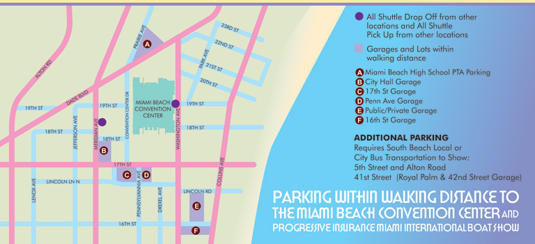
Miami Beach Convention Center Parking
High quality prints available from Society6

Fort Lauderdale International Boat Show Map
Miami International Boat Show 2026

Newport Beach International Boat Show Map

Newport International Boat Show Map

San Diego International Boat Show Map

Sarasota Boat Show Map

Windy City Boat & Yacht Show Map

Boat Show Map

A South American Boat Show Map

Boat Show Illustrated Map

Chicago International Boat Show Map

St. Pete Boat Show Map

Convention Center Map

Transportation Map Using GeoData
Transportation & Parking Map

Illustrated Map of Marinas
Convention Center Map
Yacht Haven Grande Miami
Marina Map
Transit Map
Show Proposal Rendering

Yacht Club Map
Miami International Boat Show 2025

Transportation & Parking Map
Miami Beach Convention Center

PBIBS SYBAss Map

Four Seasons Resort Lanai Map
Coastal Neighborhood Map

Resort and Marina Map

Bimini Resort and Marina Map
Miami International Boat Show 2022

Four Seasons Lanai Sanctuary Map

Proposed Motorsports Park

Restaurant Rendering

Urban Planning

Technical Illustration

Architectural Rendering

Facade Rendering

Sarasota Marina Map

Room Layout

Large Boat Show Maps

Resort Marina Map

Animal Sanctuary Maps

Illustrated Campus Map

Parking Lot Design

Beach Resort & Marina Map

Illustrated Town Map
Miami International Boat Show 2026

Boat Show Illustrated Map

Enclosure Map Rendering
Illustrated Boat Show Map
Show Proposal Rendering
Miami Yacht Show 2020
Boat Show Map

Golf Resort Map
Illustrated Show Map

Convention Center Map

Jamestown RI Map

Maryland Marina Map

Golf Resort Map

Illustrated Map of Marinas

Bed Diagram

Monument Design

Sketchy Map
Yacht Haven Grande Miami

Museum Park

Newport Beach International Boat Show Map

Fort Lauderdale Map
San Diego International Boat Show Map
Newport Beach International Boat Show Map

Colorado Ranch Map

Panhandle Marina Map

Clark Colorado
Chicago International Boat Show Map
Newport International Boat Show Map

Middle School Campus Map

School Campus Map

School and Athletic Complex Map

Athletic Complex Map

Caribbean Illustrated Resort Map
Fort Lauderdale International Boat Show Map

Palm Beach Int. Boat Show Illustrated Map
Windy City Boat & Yacht Show Map
EXPLORE MY PORTFOLIOS
- Illustration: Find custom illustration, book covers, illustrated maps, and architectural rendering.
- Fine Art: Browse original paintings and drawings, the Custom Halftone Series, and murals.
- Graphic Design & Motion: See my graphic design work, plus motion design and animated illustrations.
- Maps by industry: Illustrated maps tailored for boat shows, resorts, marinas, real estate, transit & parking, towns & cities, parks, and wayfinding.
- Other project types: Also available: cover art, vehicle & vinyl wraps, proposal renderings, and street art.
- Techniques: Explore work in vector, isometric & axonometric, painting, black & white, GeoData, overhead, and halftone styles.
- Software: Primary tools: Photoshop, Illustrator, SketchUp Pro, and InDesign. Motion work uses Premiere Pro & After Effects.