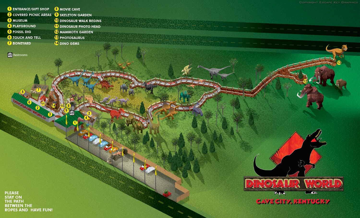
Cave City, KY Theme Park Map Illustration
Client: Dinosaur World
Also see maps for Dinosaur World FL | Dinosaur World KY | Dinosaur World TX
This is one of my earlier maps. At the time I was making all maps as isometric drawings in Adobe Illustrator. The fun, quirky, kind of cartoon like look was perfect for this attraction. Dinosaur World has parks in Florida, Kentucky and Texas all featuring loads of life size dinosaur replicas in a natural setting and lots other amenities like playgrounds and a gift shop. I later created maps for the other venues using similar methods.
The theme parks had no map when they contracted me and no CAD drawings or site plan. There was also a lot of tree canopy cover obscuring the paths and points of interest. Having just completed the map for Dinosaur World in Florida I had a methodology down and we stuck to it. I used GPS to map the paths. I also shot lots of photography including panoramic photos (which I was doing at the time). GPS and panoramic photography were pretty high tech at the time.
Using the GPS data I made Google My Maps to draw the paths as well as the positions of the dinosaurs and buildings so that I could have that all verified as correct with the client before proceeding on map creation. I still use this technique from time to time now.
Maps like this can take several layers as the geometry becomes too complex and my computer bogs down. Once a layer becomes too complex I convert the vector file to a flat bitmap. I then place it in a new file with the same proportions in Illustrator and continue adding more details, buildings or whatever is needed as vector art. Once the illustration part is complete I flatten the whole thing to a flat bitmap, place it in a new file of with the same proportions in Illustrator and create the keying and labeling etc.. This will become final files for the client so that they can make minor revisions in house. Changes to the illustration would require my intervention. I also provide files in web friendly formats (JPG and PDF).
Dinosaur World uses this map and the ones for their other parks as handouts to guests, as signage and on their website. I have made revisions over the years as Dinosaur World's parks grows and expand.
If you ever visit Cave City, in addition to Dinosaur World, I highly recommend visiting Mammoth Cave National Park. It's a truly amazing place. I enjoyed the hiking trails almost as much as I enjoyed the cave tour.
Also see maps for Dinosaur World FL | Dinosaur World KY | Dinosaur World TX


ILLUSTRATED PARK MAPS:
Illustrated park maps play an important role in helping visitors feel comfortable, informed, and confident as they explore a space. If you manage a botanical garden, work for a Parks and Recreation department, or oversee a public attraction, clear wayfinding is a key part of creating a positive guest experience. A well designed map reduces confusion, supports accessibility, and allows visitors to focus on enjoying the park rather than trying to figure out where they are.
The term park covers a wide range of destinations, from neighborhood ball fields and community parks to large nature preserves, wildlife sanctuaries, botanical gardens, theme parks, and agritourism venues. Over the years I have illustrated maps for many types of parks, each with its own layout, audience, and goals. In every case, the objective is the same: to present geographic information in a way that is easy to understand, visually engaging, and appropriate for the setting.
Each illustrated park map is tailored to the specific site and its visitors. Some projects call for a more realistic representation of the landscape, while others benefit from a lighter, more playful illustration style. Factors such as size, visitor flow, signage needs, and branding all influence the final approach. When you contact me about a park map, we will discuss your goals and challenges in detail and determine the style and level of detail that best supports your venue and your guests.
PORTFOLIO SELECTIONS
- Custom illustration & covers: Featuring bespoke illustration, book and magazine covers, hand-drawn maps, and building renderings.
- Fine art & murals: Including one-of-a-kind paintings and drawings, the Custom Halftone Series, and large-scale murals.
- Design & motion media: Covering graphic design, plus video and motion and animated illustration.
- Mapping by application: Tailored maps for marine events, hospitality, waterfront, property, transit, municipal, recreation, and navigation needs.
- Additional creative work: Includes editorial covers, vehicle graphics, concept renderings, and public art.
- Mediums & formats: Ranging from digital vector and isometric projection to traditional paint, line art, GIS-based, aerial-style, and halftone.
- Software expertise: Proficient in Photoshop, Illustrator, SketchUp, InDesign, and Premiere/After Effects for motion.