
A map of a resort in the Florida Keys
For information on Lime Tree Bay Resort please visit their official site.
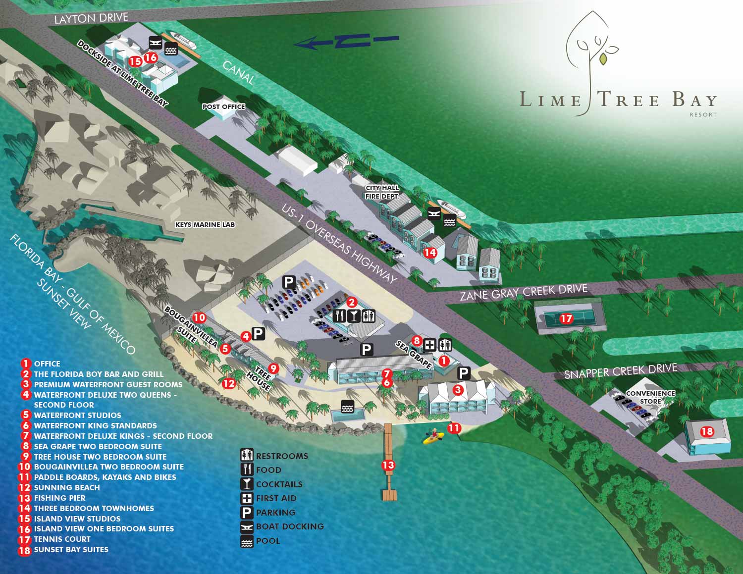
I just made a few minor revisions to this map, but it's great excuse to post an update.
Previously...
Anything But Advertising commissioned me to create an illustrated resort map for Lime Tree Bay Resort in the Florida Keys. The goal of the project was to present the property in a clear and inviting way while maintaining a refined, upscale look that reflects the character of the resort. The map is illustrated from an aerial perspective and highlights important features such as guest room locations, parking areas, restaurants, and shared amenities, allowing visitors to quickly understand how the property is laid out.
The illustration was designed to function as both a marketing piece and a practical wayfinding tool. Careful attention was given to composition, color, and detail so the map feels visually engaging without becoming overwhelming. The balanced use of realistic forms and simplified shapes helps guests orient themselves easily while reinforcing the resort’s brand and atmosphere.
This type of illustrated map is especially valuable for resorts and hospitality properties that want to improve the guest experience while strengthening their visual identity. A well designed map can help visitors feel confident and comfortable upon arrival, reduce confusion, and serve as a memorable branded asset across print and digital platforms. This project reflects my focus on creating custom resort maps that are clear, attractive, and tailored to the unique needs of each property.


Additional Portfolios:
- Augmented Reality Portfolio
- Racing Related Portfolio
- Medical Illustrations Portfolio
- Character Illustration Portfolio
- Portrait Portfolio
EXPLORE MY PORTFOLIOS
- Illustration: Find custom illustration, book covers, illustrated maps, and architectural rendering.
- Fine Art: Browse original paintings and drawings, the Custom Halftone Series, and murals.
- Graphic Design & Motion: See my graphic design work, plus motion design and animated illustrations.
- Maps by industry: Illustrated maps tailored for boat shows, resorts, marinas, real estate, transit & parking, towns & cities, parks, and wayfinding.
- Other project types: Also available: cover art, vehicle & vinyl wraps, proposal renderings, and street art.
- Techniques: Explore work in vector, isometric & axonometric, painting, black & white, GeoData, overhead, and halftone styles. Recently I have also begun to use AI for some specific solutions.
- Software: Primary tools: Photoshop, Illustrator, SketchUp Pro, and InDesign. Motion work uses Premiere Pro & After Effects.
