Illustrated Map for Boggy Creek Airboat Adventures
Visit The Boggy Creek Airboat Adventures website at BCAirboats.com
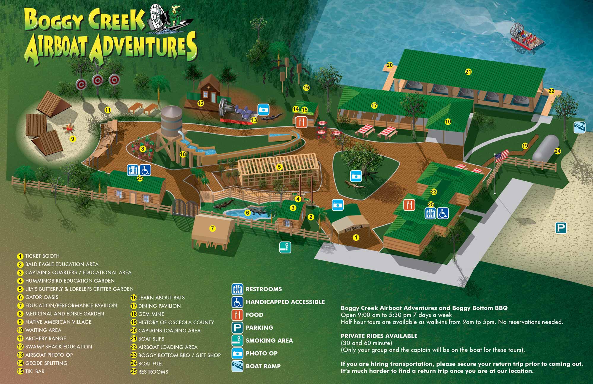
I am pleased to present the new illustrated map for Boggy Creek Airboat Adventures in Kissimmee, Florida on beautiful Lake Tohopekaliga. In addition to thrilling airboat rides the park features multiple exhibits and points of interest and a great restaurant. Learn more on their website at BCAirboats.com.
This illustrated map was created in Adobe Illustrator using an isometric or axonometric technique. I visited the park prior to creating the map and collected photographic and GPS reference. The staff at the park guided me through anything I couldn't figure out from those materials. Their support and patience is greatly appreciated.


ILLUSTRATED PARK MAPS:
Illustrated park maps play an important role in helping visitors feel comfortable, informed, and confident as they explore a space. If you manage a botanical garden, work for a Parks and Recreation department, or oversee a public attraction, clear wayfinding is a key part of creating a positive guest experience. A well designed map reduces confusion, supports accessibility, and allows visitors to focus on enjoying the park rather than trying to figure out where they are.
The term park covers a wide range of destinations, from neighborhood ball fields and community parks to large nature preserves, wildlife sanctuaries, botanical gardens, theme parks, and agritourism venues. Over the years I have illustrated maps for many types of parks, each with its own layout, audience, and goals. In every case, the objective is the same: to present geographic information in a way that is easy to understand, visually engaging, and appropriate for the setting.
Each illustrated park map is tailored to the specific site and its visitors. Some projects call for a more realistic representation of the landscape, while others benefit from a lighter, more playful illustration style. Factors such as size, visitor flow, signage needs, and branding all influence the final approach. When you contact me about a park map, we will discuss your goals and challenges in detail and determine the style and level of detail that best supports your venue and your guests.
PORTFOLIO SELECTIONS
- Custom illustration & covers: Featuring bespoke illustration, book and magazine covers, hand-drawn maps, and building renderings.
- Fine art & murals: Including one-of-a-kind paintings and drawings, the Custom Halftone Series, and large-scale murals.
- Design & motion media: Covering graphic design, plus video and motion and animated illustration.
- Mapping by application: Tailored maps for marine events, hospitality, waterfront, property, transit, municipal, recreation, and navigation needs.
- Additional creative work: Includes editorial covers, vehicle graphics, concept renderings, and public art.
- Mediums & formats: Ranging from digital vector and isometric projection to traditional paint, line art, GIS-based, aerial-style, and halftone.
- Software expertise: Proficient in Photoshop, Illustrator, SketchUp, InDesign, and Premiere/After Effects for motion.