
Newport Beach International Boat Show in Newport Beach, California – Illustrated Map 2026
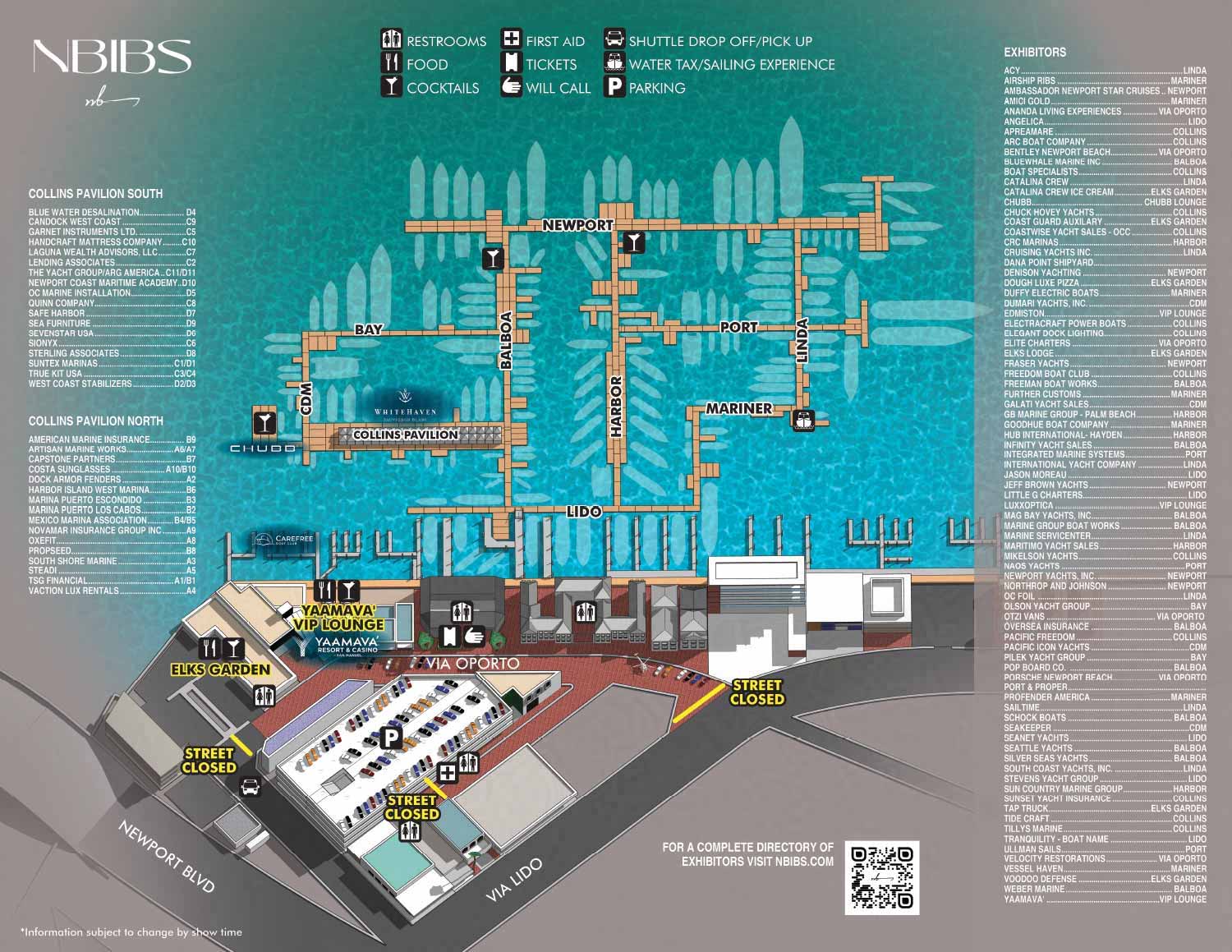
I created this map for the 2026 Newport Beach International Boat Show, working with Revel Republic. If you need attendance or ticket information, please visit NBIBS.com. If you are here to learn about how this map came together, read on.
Behind the Map: Newport Beach International Boat Show 2026
I recently completed the illustrated map for the 2026 Newport Beach International Boat Show, my fourth year working with Revel Republic on this event. It was my first west coast boat show map when I started, and it still feels good to come back to.
The show takes place in Newport Beach, one of Southern California's most desirable coastal settings. The atmosphere is upscale but relaxed, which fits the waterfront culture of the area. My map needed to match that tone while still doing the practical work of getting people where they need to go.
I built the venue as a three dimensional model in SketchUp to get the scale and lighting right, then refined the renderings in Photoshop. That model now serves as the foundation for each year's map. Because the show footprint is compact, I took a different approach to exhibitor listings. Instead of using numbers, I cross reference exhibitors to clearly named docks. Names are easier to remember.
Key points of interest are labeled on the map, and facilities like restrooms and ticket sales appear as simple icons. The result is a map that balances a polished look with real world wayfinding.
If you need a custom map for your own venue, contact me. I would be glad to do the same for you.
MAPS FOR THE NEWPORT BEACH INTERNATIONAL BOAT SHOW:
MAPS FOR BOAT SHOWS IN CALIFORNIA:


BROWSE MY WORK
- Illustration: Browse custom illustrations, book cover art, illustrated maps, and architectural renderings.
- Fine art: View original paintings and drawings, the Custom Halftone Series, and mural commissions.
- Graphic design & motion: See design projects, then watch motion reels and animated pieces.
- Maps by use case: Explore illustrated maps created for boat shows, resorts, marinas, real estate, transportation & parking, cities & towns, parks, and wayfinding.
- Specialty projects: Also check out cover design, vinyl & vehicle wraps, proposal renderings, and street art.
- Style & technique: Discover vector, isometric, painterly, monochrome, data-driven, bird's-eye, and halftone approaches.
- Tools I use: Everyday software includes Photoshop, Illustrator, SketchUp, and InDesign; motion work relies on Premiere & After Effects. Recently I have begun some work using AI as well.
