
Illustrated Overhead Marina and Residential Map
Client: Tingdene Marinas & Boat Sales UK
For information on Upton Marina please visit Tingdene-Marinas.co.uk/marinas/upton-marina/
For information on Upton Waterfront Living please visit Waterfront-Living.com/Upton-Lake/
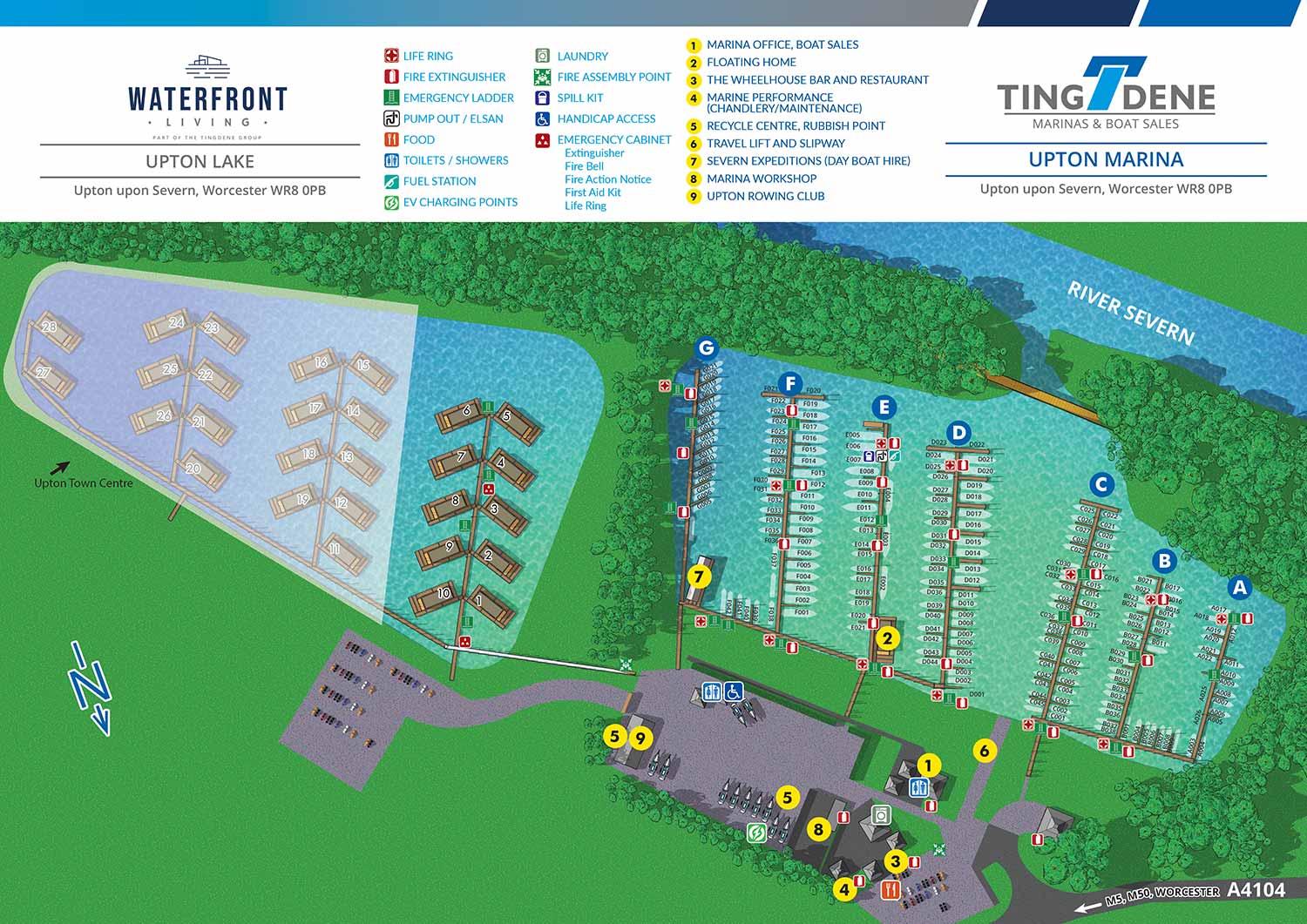
This illustrated map brings together a full service marina and a thoughtfully planned community of residential floating homes. The result is a clear visual representation of a lifestyle that blends a passion for boating with the comfort of living on England’s scenic waterways. Residents enjoy beautifully designed floating homes set within a peaceful marina environment, where daily life includes expansive water views and a strong connection to the surrounding landscape.
Upton Marina is a well established inland marina offering secure pontoon and bankside moorings for a wide range of vessels, along with hardstanding storage and dedicated visitor berths. Located on the River Severn, the longest river in Britain, the marina sits south of the historic city of Worcester and north of Tewkesbury. From Upton upon Severn, boaters have access to an extensive network of inland waterways, making travel to many parts of England possible by water.
Escape Key Graphics created this illustrated marina and floating residence map to clearly communicate both the layout and the character of the property. The overhead view allows viewers to quickly understand the relationship between the marina facilities and the residential floating homes. Slips, access points, and key features are clearly identified, supporting intuitive wayfinding while presenting the development in a polished and professional manner.
The map is used as a flexible marketing asset across multiple formats, including digital presentations, printed materials, and on site displays. By combining accuracy with refined illustration, the map helps attract prospective residents and marina users while serving as a practical reference for visitors and staff alike.


WORK FOR TINGDENE - COMBINED MARINA AND RESIDENTIAL PARK MAPS:


PORTFOLIO GALLERIES
- Illustration work: Start with custom illustration and cover design, then view illustrated maps and architectural renderings.
- Fine art: Discover original paintings and drawings, the Custom Halftone Series, and mural projects.
- Design & motion: Check out the graphic design gallery, then move on to motion graphics and animated illustration.
- Maps by sector: I produce illustrated maps for boat shows, resorts, marinas, real estate, transit & parking, towns & cities, parks, and wayfinding systems.
- More creative services: Additional offerings include cover illustration, vehicle wraps, proposal renderings, and street art.
- Artistic methods: My work spans vector art, isometric & axonometric views, traditional painting, black & white illustration, GeoData mapping, overhead perspectives, and halftone effects.
- Preferred software: I rely on Photoshop, Illustrator, SketchUp Pro, and InDesign, plus Premiere Pro & After Effects for motion projects.