
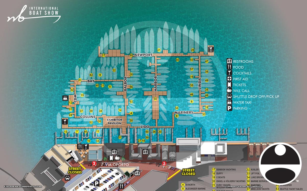
Newport Beach International Boat Show in Newport Beach, California – Illustrated Map 2023
Client: Revel Republic
I am the illustrator and designer of this map. If you want the latest and most accurate information about attending the Newport Beach International Boat Show please visit their official site at NBIBS.com
I am very proud to contribute to a new marine event on the West Coast of the United States. It is exciting to collaborate with a new team, address fresh creative challenges, and participate in the launch of something new. Boat shows of this scale have been less common on the West Coast in recent years, so this event feels particularly significant. It may signal a positive resurgence in the regional boat and yacht market, promising to generate welcome economic activity for the local community and help grow the marine industry in the area.
For the inaugural 2023 Newport Beach International Boat Show, we implemented a clear keying system for navigation. A numbered system on highly visible yellow dots was layered directly onto the illustration. Land based points of interest were further distinguished with numbered red dots, while amenities were indicated using a set of intuitive graphical icons.
The map was created using CAD style technical drawings supplied by the client. As with most boat show projects, the primary updates in future years will involve modifications to floating dock arrangements and some reorganization of land based exhibits. From a graphic design perspective, this process will involve updating the exhibitor listings in the key and adjusting specific labels on the map itself.
The marine event industry is inherently dynamic. Last minute adjustments are a standard part of the process, with new exhibitors confirming their participation and sponsors revising their plans close to the event date. It is common practice for clients to include disclaimers noting that information is subject to change after materials are printed or published. This fluid working environment is a primary reason many illustrators might be hesitant to undertake such projects. Successfully creating accurate and timely boat show maps requires an illustrator and designer who is not only precise but also efficient and highly adaptable to evolving requirements.
Illustrated event maps fulfill a distinct and valuable role by enabling potential attendees to clearly visualize their experience before arrival. Rather than relying on generic stock photography, guests can examine an accurate and detailed representation of the actual event layout. These maps effectively communicate the event's scale and physical setting while delivering practical information about amenities, including restroom locations, food and beverage access, and transportation or parking options. As a result, illustrated maps function as both aesthetically pleasing graphics and genuinely useful informational and marketing resources.
For more examples of my illustrative cartography for events, please visit my Maps Portfolio.
MAPS FOR THE NEWPORT BEACH INTERNATIONAL BOAT SHOW:


PORTFOLIO SELECTIONS
- Custom illustration & covers: Featuring bespoke illustration, book and magazine covers, hand-drawn maps, and building renderings.
- Fine art & murals: Including one-of-a-kind paintings and drawings, the Custom Halftone Series, and large-scale murals.
- Design & motion media: Covering graphic design, plus video and motion and animated illustration.
- Mapping by application: Tailored maps for marine events, hospitality, waterfront, property, transit, municipal, recreation, and navigation needs.
- Additional creative work: Includes editorial covers, vehicle graphics, concept renderings, and public art.
- Mediums & formats: Ranging from digital vector and isometric projection to traditional paint, line art, GIS-based, aerial-style, and halftone.
- Software expertise: Proficient in Photoshop, Illustrator, SketchUp, InDesign, and Premiere/After Effects for motion. More recently I have worked with AI.