
Docks and exhibitors identified in an overhead view
Client: Allsports Productions
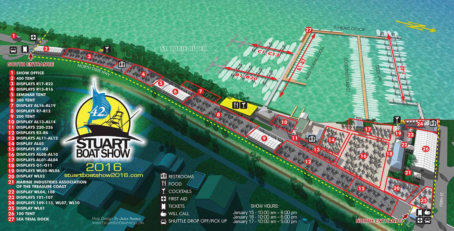
This was my first year creating the map for the Stuart Boat Show, and working with the team at Allsports Productions has been both a pleasure and a rewarding challenge. Starting a new show from scratch allowed me to apply years of experience while making decisions entirely from the ground up. I incorporated three-dimensional trees to add depth and clarity to the overall layout.
The docks are clearly labelled, and major points of interest, primarily exhibitor displays, are keyed using a numbered system. These numbers appear on red dots, with show sections outlined in matching red lines. This approach not only provides functional navigation but also creates a striking contrast against the predominantly green illustration beneath, enhancing visual appeal. Amenities are indicated with simple, intuitive icons, which is particularly helpful for recurring features such as restrooms and food services.
Overall, this map balances practical wayfinding with an elegant design, making it one of the most visually engaging and aesthetically satisfying maps I have created.


BOAT SHOW MAPS ARTICLE - SOUTHERN BOATING MAGAZINE 2016:
"Navigating Miami’s multiple venues is easier when you use a map. If you’re at Yachts Miami Beach – formerly The Miami Yacht and Brokerage Show – the man behind those maps is John Potter of Escape Key Graphics, who created his first boat show map for the 201 Fort Lauderdale Int’l. Boat Show. It wasn't long before the creative concept spread. Less intimidating than site plans and more easier to follow than an aerial photography, Potter’s maps now grace the Stuart Boat Show, St. Petersburg Power & Sailboat Show in Florida and International Boat Shows like Newport, Palm Beach and Panama. His work on these shows frequently extends to many maps such as detailed area maps and transit maps. Potter’s maps can also be seen beyond the yachting industry in theme parks, resorts, wildlife sanctuaries, municipalities, campuses and gardens including Flamingo Gardens, Dinosaur World parks or The Dover International Speedway."
ADDENDUM:
I am presently responsible for illustrated maps for The Chicago International Boat Show, The Fort Lauderdale International Boat Show, The Miami International Boat Show, The Newport International Boat Show, The Newport Beach International Boat Show, The San Diego International Boat Show, The Windy City Boat & Yacht Show, The Palm Beach International Boat Show, The Suncoast Boat Show and the The Saint Petersburg Power and Sailboat Show.
There is a directory in my Boat Show Map Portfolio
PORTFOLIO SELECTIONS
- Custom illustration & covers: Featuring bespoke illustration, book and magazine covers, hand-drawn maps, and building renderings.
- Fine art & murals: Including one-of-a-kind paintings and drawings, the Custom Halftone Series, and large-scale murals.
- Design & motion media: Covering graphic design, plus video and motion and animated illustration.
- Mapping by application: Tailored maps for marine events, hospitality, waterfront, property, transit, municipal, recreation, and navigation needs.
- Additional creative work: Includes editorial covers, vehicle graphics, concept renderings, and public art.
- Mediums & formats: Ranging from digital vector and isometric projection to traditional paint, line art, GIS-based, aerial-style, and halftone.
- Software expertise: Proficient in Photoshop, Illustrator, SketchUp, InDesign, and Premiere/After Effects for motion. More recently I have worked with AI.