Illustrated Town Map - Illustrated map for a municipality
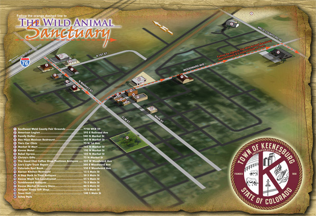
Illustrated Town Map - I have just completed this illustrated map of Keenesburg, Colorado, adding to my portfolio of maps for towns and cities. Keenesburg (about 40 miles from Denver) is the home of The Wild Animal Sanctuary. You may recall that I recently produced some maps for them.
I would like to extend many thanks to the folks with the Town of Keenesburg including Debra Chumley and Mayor Danny Kipp as well as Pat Craig at The Wild Animal Sanctuary.
The town has plans to use the map on a kiosk. I look forward to seeing it.
Escape Key Graphics’ vector based maps can be blown up to a poster of any size with little or no degradation and Escape Key Graphics’ 3D maps can be rendered from different angles and zoom extents creating endless new possibilities. The 3D method can also provide a more realistic look than the vector method. In both cases buildings, paths and everything else in your map is like an object that can be moved, shrunk, deleted, etc, making revisions easy and quick. Expansion of your park, site, or facilities seldom means recreating your map from scratch.
Escape Key Graphics can create great maps for boat shows, towns and cities, campuses, hospitals, housing complexes or just about any other place. Escape Key Graphics can show how work flows through your factory, how an ecosystem works or produce any of a number of other map like visual solutions.
Other projects and clients include: