Illustrated Map for the Wild Animal Sanctuary
Client: The Wild Animal Sanctuary
Visit The Wild Animal Sanctuary website at WildAnimalSanctuary.org
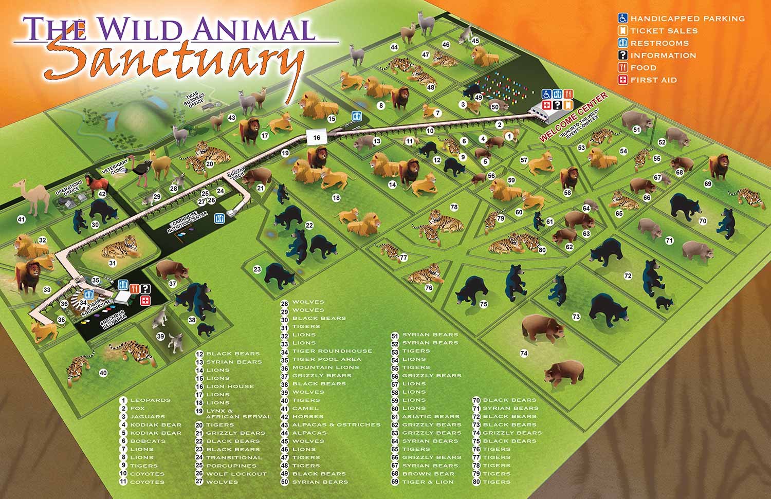
I was commissioned to create an illustrated map for The Wild Animal Sanctuary in Keenesburg, Colorado, a renowned facility dedicated to rescuing and providing lifelong care for exotic and endangered animals. The sanctuary is known for giving its animals expansive habitats, allowing them to roam freely in wide open spaces. While this approach is ideal for the animals, it presented a unique challenge from a design perspective: if the animals were rendered to scale, they would appear as tiny, nearly invisible dots on the map.
To address this, I created enlarged spot illustrations of the animals, allowing visitors to easily identify each species while adding a sense of whimsy and engagement to the map. Similarly, features such as the sanctuary’s elevated walkway were scaled proportionally larger than reality to make them visually prominent, guiding guests along paths and key viewpoints. A numbered key identifies each animal enclosure, while intuitive icons highlight essential amenities such as restrooms, picnic areas, and visitor centers.
The resulting map combines functional wayfinding with playful illustration, helping guests navigate the sanctuary with ease while emphasizing the sanctuary’s mission and immersive experience. It has been used across multiple platforms, including on-site signage, printed guides, and the sanctuary’s website. This project demonstrates how custom illustration can balance accuracy, readability, and creativity, enhancing both visitor experience and engagement for wildlife attractions.
2017 Wild Animal Sanctuary Main Map2015 Wild Animal Sanctuary Main Map | 2015 Tiger Roundhouse
2015 Mile Into The Wild | 2015 Bolivian Lion House
2013 Wild Animal Sanctuary Main Map | 2013 Tiger Roundhouse
2013 Mile Into The Wild | 2013 Bolivian Lion House
PARK AND THEME PARK MAPS:


ILLUSTRATED PARK MAPS:
Illustrated park maps play an important role in helping visitors feel comfortable, informed, and confident as they explore a space. If you manage a botanical garden, work for a Parks and Recreation department, or oversee a public attraction, clear wayfinding is a key part of creating a positive guest experience. A well designed map reduces confusion, supports accessibility, and allows visitors to focus on enjoying the park rather than trying to figure out where they are.
The term park covers a wide range of destinations, from neighborhood ball fields and community parks to large nature preserves, wildlife sanctuaries, botanical gardens, theme parks, and agritourism venues. Over the years I have illustrated maps for many types of parks, each with its own layout, audience, and goals. In every case, the objective is the same: to present geographic information in a way that is easy to understand, visually engaging, and appropriate for the setting.
Each illustrated park map is tailored to the specific site and its visitors. Some projects call for a more realistic representation of the landscape, while others benefit from a lighter, more playful illustration style. Factors such as size, visitor flow, signage needs, and branding all influence the final approach. When you contact me about a park map, we will discuss your goals and challenges in detail and determine the style and level of detail that best supports your venue and your guests.
ANIMAL RELATED ILLUSTRATIONS:


PORTFOLIOS
- Illustration Portfolio: Start here for custom illustration and book covers. You can also browse illustrated maps and architectural rendering.
- Fine Art: I offer original paintings and drawings, including my Custom Halftone Series. You will also find mural work here.
- Graphic Design & Motion: View my graphic design portfolio. After that, explore motion design and animated illustrations.
- Maps by application: I create illustrated maps for boat shows, resorts, marinas, real estate, transportation, transit and parking, towns and cities, parks, and wayfinding.
- Additional project types: I also produce cover illustration, vehicle and vinyl wraps, proposal renderings, and street art.
- Illustration methods: My techniques include vector, isometric and axonometric, painting, black and white, GeoData maps, overhead maps, and custom halftones.
- Software portfolios: I work primarily in Adobe Photoshop, Adobe Illustrator, SketchUp Pro, and Adobe InDesign. For motion projects, I use Premiere Pro and After Effects. You can watch my demo reel here.