Architectural Style Map for a Wild Animal Refuge
Client: The Wild Animal Sanctuary
Visit The Wild Animal Sanctuary website at WildAnimalSanctuary.org
The Wild Animal Sanctuary in Keenesburg, Colorado is an organization I have long been honored to work with. Their mission is straightforward and vital. They rescue and provide lifelong homes for large, exotic, and endangered captive wild animals that have been abandoned or neglected. They also educate the public about the global captive wildlife crisis. It is the kind of work that matters, and contributing to it in any small way feels good.
A Different View of the Sanctuary
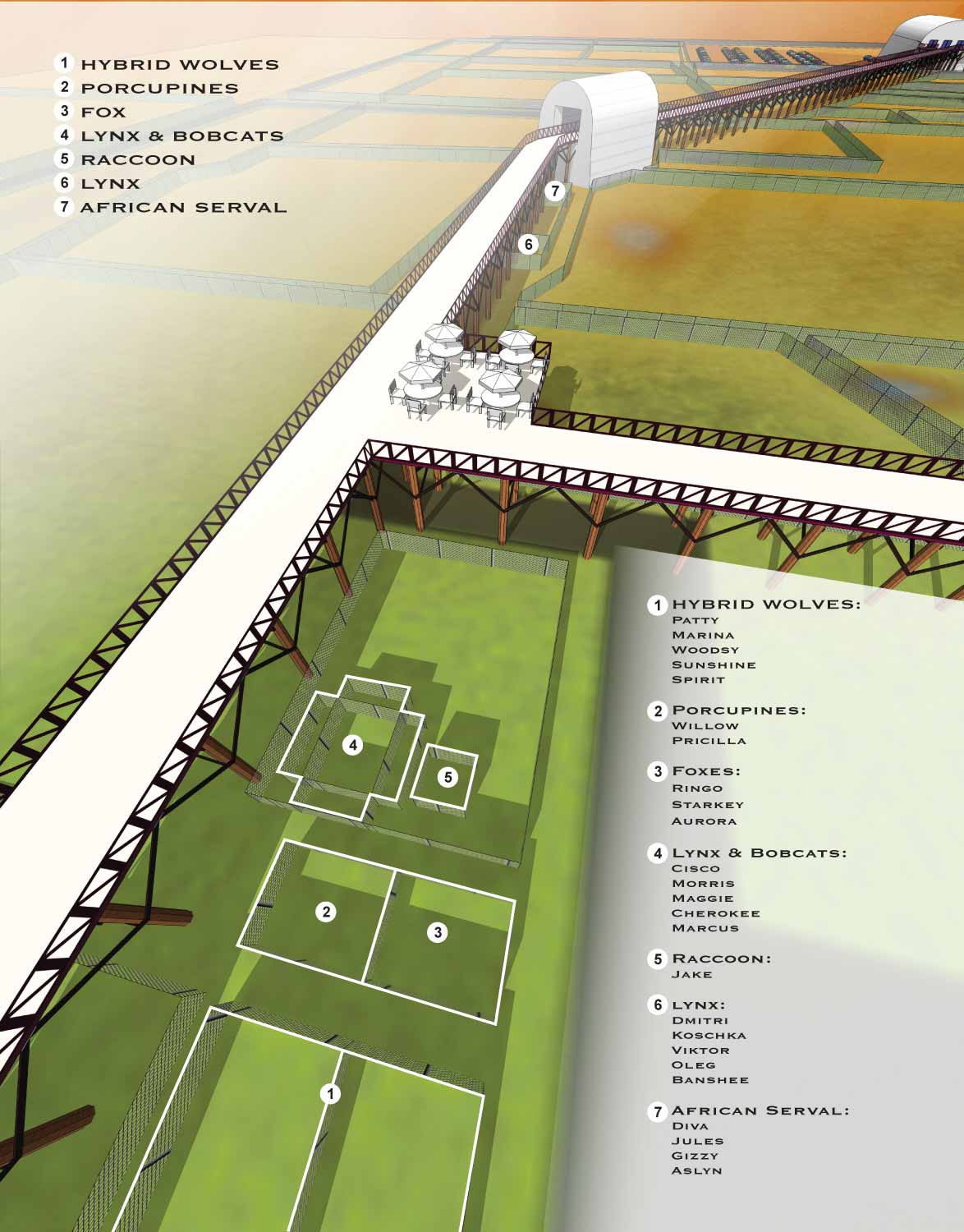
This map, titled "Mile Into the Wild," focuses on a different area of the sanctuary than my previous work for them. It highlights the expansive habitats on the the property and the walking paths that wind through them.
Like the elevated walkway map, this one was built to help visitors orient themselves in a place that is unlike any typical park. The scale is large, and the animal habitats are spread out. A clear map makes the difference between a confusing visit and an enjoyable one.
My Process for This Map
I created this illustration using the same master three dimensional digital model I built for the sanctuary's overall grounds. For this specific view, I positioned virtual cameras to capture the right angle and perspective. After rendering those views, I brought the images into Photoshop for retouching, cropping, and any necessary edits. The final step was bringing everything into Adobe Illustrator to place logos, graphics, and the map key that helps visitors identify what they are looking at.
Form and Function Together
The goal with any map for a place like this is to balance visual appeal with practical use. Visitors need to find their way, but they also deserve a map that reflects the beauty and importance of the sanctuary itself. These maps are used on site for wayfinding and online to give potential visitors a preview of the experience.
Your Project
If you need similar work for a sanctuary, a park, a refuge, or any other venue that requires clear, thoughtful, and visually engaging maps, contact me. I have done this work before and I would be glad to do it for you.
2017 Wild Animal Sanctuary Main Map
2015 Wild Animal Sanctuary Main Map | 2015 Tiger Roundhouse
2015 Mile Into The Wild | 2015 Bolivian Lion House
2013 Wild Animal Sanctuary Main Map | 2013 Tiger Roundhouse
2013 Mile Into The Wild | 2013 Bolivian Lion House
PARK AND THEME PARK MAPS:


PORTFOLIOS
- Illustration Portfolio: Start here for custom illustration and book covers. You can also browse illustrated maps and architectural rendering.
- Fine Art: I offer original paintings and drawings, including my Custom Halftone Series. You will also find mural work here.
- Graphic Design & Motion: View my graphic design portfolio. After that, explore motion design and animated illustrations.
- Maps by application: I create illustrated maps for boat shows, resorts, marinas, real estate, transportation, transit and parking, towns and cities, parks, and wayfinding.
- Additional project types: I also produce cover illustration, vehicle and vinyl wraps, proposal renderings, and street art.
- Illustration methods: My techniques include vector, isometric and axonometric, painting, black and white, GeoData maps, overhead maps, and custom halftones.
- Software portfolios: I work primarily in Adobe Photoshop, Adobe Illustrator, SketchUp Pro, and Adobe InDesign. For motion projects, I use Premiere Pro and After Effects.