
2015 edits to the map
Client: The Wild Animal Sanctuary
Visit The Wild Animal Sanctuary website at WildAnimalSanctuary.org
The Wild Animal Sanctuary in Keenesburg, Colorado does important work. They prevent and alleviate cruelty to animals that have been abandoned, deprived, or neglected by providing care and boarding. They also rescue and provide lifelong homes for large, exotic, and endangered captive wild animals. On top of that, they educate the public about the causes of and solutions to the world's captive wildlife crisis. It has always been an honor to collaborate with an organization that has such a positive mission.
The Elevated Walkways
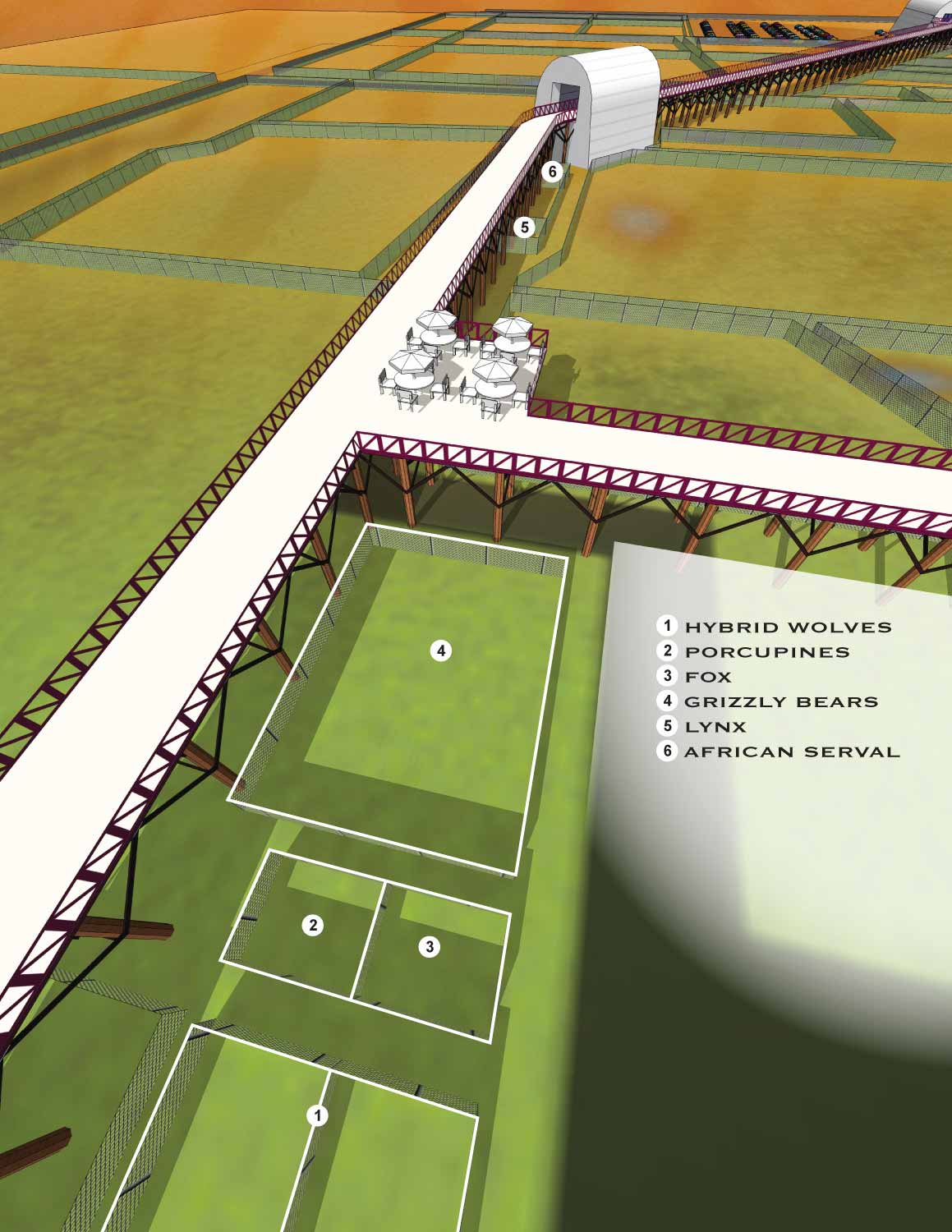
The sanctuary features a mile and a half of elevated walkways. These pathways are high, around 15 feet on average if I remember correctly. They let visitors observe the animals without disturbing the wildlife or putting themselves at risk. In the specific area this map shows, some of the animal enclosures are positioned closer to the walkway, which gives guests a more intimate view while still maintaining a respectful distance.
How I Made the Map
I created this map from a three dimensional digital model that served as the master file for all the sanctuary's maps. I set up multiple virtual cameras at different locations in the model and rendered images for use as illustrations on different maps. Once the rendering was done, I brought the images into Photoshop for retouching, cropping, and editing. Final placement of logos, graphics, and the map key happened in Adobe Illustrator.
Where the Maps Are Used
These maps are used on site for wayfinding, helping visitors navigate the sanctuary and understand where they are in relation to the animals and walkways. They also appear online as a marketing tool, giving potential visitors a preview of what the experience is like before they arrive.
Your Project
If you need similar work for a sanctuary, a park, or any other venue that requires clear, visually engaging maps, contact me. I have done this work before and I would be glad to do it for you.
2017 Wild Animal Sanctuary Main Map
2015 Wild Animal Sanctuary Main Map | 2015 Tiger Roundhouse
2015 Mile Into The Wild | 2015 Bolivian Lion House
2013 Wild Animal Sanctuary Main Map | 2013 Tiger Roundhouse
2013 Mile Into The Wild | 2013 Bolivian Lion House


BROWSE MY WORK
- Illustration: Browse custom illustrations, book cover art, illustrated maps, and architectural renderings.
- Fine art: View original paintings and drawings, the Custom Halftone Series, and mural commissions.
- Graphic design & motion: See design projects, then watch motion reels and animated pieces.
- Maps by use case: Explore illustrated maps created for boat shows, resorts, marinas, real estate, transportation & parking, cities & towns, parks, and wayfinding.
- Specialty projects: Also check out cover design, vinyl & vehicle wraps, proposal renderings, and street art.
- Style & technique: Discover vector, isometric, painterly, monochrome, data-driven, bird's-eye, and halftone approaches.
- Tools I use: Everyday software includes Photoshop, Illustrator, SketchUp, and InDesign; motion work relies on Premiere & After Effects. Recently I have begun some work using AI as well.