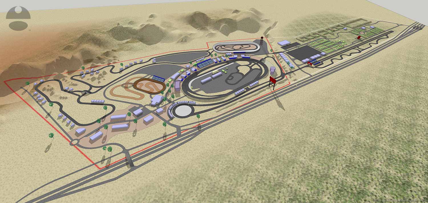
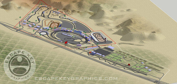
Race Track and Facilities Architectural Rendering / Map
Client: Pikes Peak International Raceway
This map was created for planning purposes from rough site plans.
Nestled in the high desert of Fountain, Colorado, Pikes Peak International Raceway (PPIR) occupies a unique and storied landscape. Situated conveniently between Colorado Springs and Pueblo, the facility is characterized by vast, open skies and panoramic mountain views, set upon a terrain of sweeping plains dotted with resilient native flora.
This is no ordinary circuit. Rising on the foundation of the former Pikes Peak Meadows horse track, PPIR opened in 1997 and swiftly earned a reputation for speed. Its distinctive 1-mile D-shaped oval and integrated road course were engineered for velocity, cementing its status as one of the nation's premier paved racing venues.


Visualizing Expansion: A Cartographic Partnership
Escape Key Graphics was commissioned by Pikes Peak International Raceway to envision the potential future of their iconic facility. The project required detailed illustrative renderings to conceptualize expansion possibilities, blending proposed developments seamlessly with the existing infrastructure.
To achieve this, I constructed a comprehensive digital 3D model of the raceway and its surrounding environment. This versatile model served as the foundational tool for generating a wide array of illustrative views. A key artistic decision was to stylize and enhance the region's topography, carefully exaggerating landforms to improve visual clarity and conceptual understanding without sacrificing the authentic sense of place.
This project marked a significant milestone in my illustration portfolio, representing my first major foray into landscape-focused mapping where terrain elevation became a central, expressive element of the artwork.
Efficiency Through Advanced Modeling
The strategic advantage of this 3D modeling approach was its inherent flexibility. Once the initial, detailed model was complete, I could rapidly produce numerous high-quality renderings. This capability allowed me to provide PPIR with diverse perspectives, from sweeping aerial overviews to detailed zoomed-in extracts, each tailored to highlight specific aspects of their expansion vision. This method ensured both artistic depth and project efficiency, delivering a powerful visual toolkit for planning and presentation.
Explore the full scope of my illustration and cartographic work at Escape Key Graphics.
To learn more about the history and events at this legendary Colorado speedway, please visit the official Pikes Peak International Raceway website.
RACING RELATED ILLUSTRATION:


WHAT IS SKETCHUP?:
SketchUp, originally developed by Google and now maintained by Trimble Inc., is a powerful 3D modeling program widely used across architecture, interior design, marine architecture, civil and mechanical engineering, and even film and video game production. While it is not intended for character design or organic modeling, SketchUp excels at creating precise, technical models using basic shapes, making it ideal for architectural renderings, site planning, and technical illustrations.
I first began using SketchUp in 2012 while creating the illustrated map for the St. Petersburg Power and Sailboat Show. At the time, I was seeking an efficient alternative to isometric drawing for map illustration. Since then, I have expanded its use across a variety of projects and now rely on SketchUp almost daily to create accurate, visually compelling 3D models for maps, buildings, and other technical illustrations.
SketchUp allows me to combine technical precision with artistic flexibility. Models created in SketchUp can be used as the foundation for detailed illustrations, integrated with Adobe Illustrator or Photoshop, or exported for presentation and visualization purposes. Its versatility makes it a valuable tool for projects that require accurate spatial representation, clear perspective, and a professional, polished look.
If you are interested in having a custom model or illustration created in SketchUp, please contact me for a quote. I can provide solutions for everything from complex architectural layouts to 3D maps and technical renderings tailored to your specific project needs.
PORTFOLIOS
- Illustration Portfolio: Start here for custom illustration and book covers. You can also browse illustrated maps and architectural rendering.
- Fine Art: I offer original paintings and drawings, including my Custom Halftone Series. You will also find mural work here.
- Graphic Design & Motion: View my graphic design portfolio. After that, explore motion design and animated illustrations.
- Maps by application: I create illustrated maps for boat shows, resorts, marinas, real estate, transportation, transit and parking, towns and cities, parks, and wayfinding.
- Additional project types: I also produce cover illustration, vehicle and vinyl wraps, proposal renderings, and street art.
- Illustration methods: My techniques include vector, isometric and axonometric, painting, black and white, GeoData maps, overhead maps, and custom halftones.
- Software portfolios: I work primarily in Adobe Photoshop, Adobe Illustrator, SketchUp Pro, and Adobe InDesign. For motion projects, I use Premiere Pro and After Effects.