Miami Beach Yacht Collection on Collins Ave - Illustrated Map - 2026
Client: Informa Markets
For information about the Miami International Boat Show and to ensure you're seeing the latest maps and information visit MiamiBoatShow.com

Built on a Strong Foundation
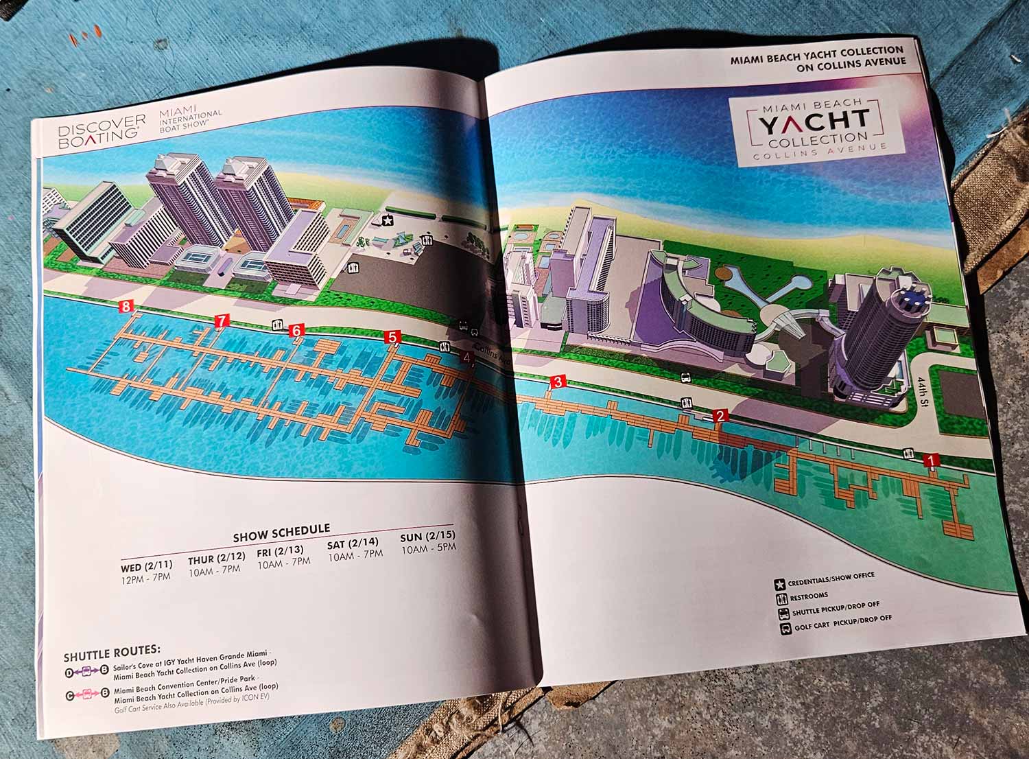
The Miami International Boat Show made a major change by moving its main hub from downtown’s Venetian Marina to Collins Avenue in Miami Beach. I had already created a detailed three dimensional digital model of this area for earlier projects, so I started the map with real advantages. Famous landmarks like the Fontainebleau and the Eden Roc remain in place and help people get their bearings. The show now stretches roughly from 44th Street north to the Blue and Green Diamond towers.
Form and Function Combined
This digitally rendered aerial map balances clear navigation with visual appeal. Dock ramps stand out with numbered red markers. A full set of graphical icons identifies facilities and amenities at a glance. I included a shuttle route guide and the show schedule right on the map, turning it into an all in one tool for visitors. The color scheme captures the coastal feel of Miami Beach, and the detailed architecture along Collins Avenue gives attendees familiar points to navigate by.
Maps for Every Venue and Format
The 2026 show takes place across four different venues, and I produced a custom map for each one. A transportation map was also created, with versions tailored for the web, on site signage, and the printed program. For the Miami Beach Yacht Collection along Collins Avenue, I designed a vertical layout specifically for large format signs. Every version shares the same visual identity, but each one is optimized for its own viewing environment and space limits.
Your First and Best Pre Event Tool
Event organizers often turn to stock photos or bold generic graphics during the early marketing phase. Those images can look great, but they cannot show an event that has not happened yet. A detailed custom map fills that gap completely. It gives potential attendees, exhibitors, and sponsors a confident preview of the layout and scale. This turns the map into a serious marketing asset that builds real anticipation. Instead of just helping people find their way, it communicates professionalism and preparation from the start. When used early, an illustrated map becomes a core piece of your event story, not just a handout for the day of the show.
Miami International Boat Show Maps 2026:
Miami Beach Yacht Collection on Collins Ave | Yacht Haven Grande Miami | Miami Beach Convention Center Map | Transportation Map | Pride Park MapEXAMPLES OF MAPS CREATED FOR MIAMI BOAT SHOWS:


Maps For Boat Shows In Miami:
- About Miami Boat Shows
- Miami International Boat Show / Miami Yacht Show / Yachts Miami Beach / Miami Beach Yacht and Brokerage Show - Show Center/Primary Venue Maps: 2026 | 2025 | 2024 | 2023 | 2022 | 2020 | 2019 | 2018 | 2017 | 2016 | 2015 | 2014 | 2013 | 2012 | 2011
- Transportation Map: 2026 | 2025 | 2024 | 2023 | 2022 | 2020 | 2019 | 2016 | 2013 | 2012
- Program Layout: 2026 | 2025 | 2024 | 2023 | 2022
- Yacht Haven Grande at Island Gardens: 2026 | 2022 | 2020 | 2016
- Miami Beach Convention Center: 2026 | 2025 | 2024 | 2023 | 2022 | 2013 | 2012
- Sea Isle Marina Only: 2013 | 2012
- Miamarina at Bayside Only: 2013 | 2012 | 2011
- Bayfront Park: 2015
- Museum Park Marina: 2025 | 2024 | 2023 | 2022
- Illustration (not a map): 2014
- Video: 2013
EXPLORE MY WORK
- Illustration: Discover custom illustrations, book covers, illustrated maps, and architectural renderings.
- Fine Art: Browse original paintings and drawings, view the Custom Halftone Series, or check out mural projects.
- Graphic Design & Motion: See the graphic design collection, then dive into motion design and animated illustrations.
- Maps by industry: View illustrated maps tailored for boat shows, resorts, marinas, real estate, transportation, towns, parks, and wayfinding.
- More project types: Explore cover art, vehicle wraps, proposal renderings, and street art.
- Techniques & styles: Work spans vector, isometric, painting, black-and-white, GeoData, overhead maps, and halftones.
- Software expertise: Primary tools include Photoshop, Illustrator, SketchUp Pro, and InDesign, plus Premiere Pro & After Effects for motion.