Yacht Haven Grande Miami At Island Gardens - Sailor's Cove - Illustrated Map - 2026
Client: Informa Markets
For information about the Miami International Boat Show and to ensure you're seeing the latest maps and information visit MiamiBoatShow.com

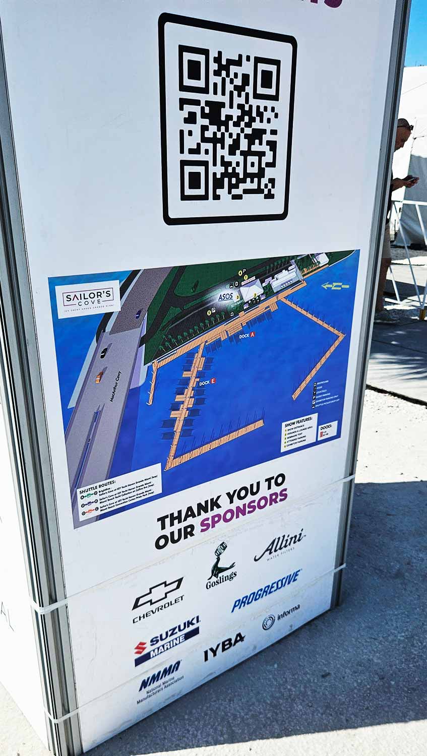
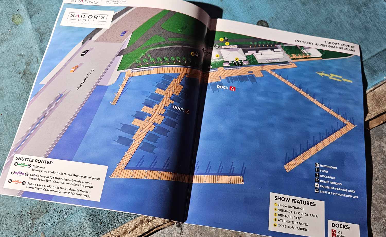
A Welcome Return to Watson Island
The 2026 Miami International Boat Show brings back Island Gardens Marina as a featured venue. Now called Sailor's Cove, this waterfront location will host an impressive lineup of new yachts in a setting built for sailing enthusiasts. You will find it along the MacArthur Causeway just after you leave mainland Miami. The location is easy to reach, yet it still feels distinct from the other show sites. Organizers actually encourage visitors to park here and take shuttles to the remaining venues, which makes for a smarter traffic flow overall.
Built from a Digital Model
I created this illustrated map from a custom three dimensional digital model. Numbered yellow markers call out key show features, and a clean icon system identifies visitor amenities at a glance. Dock labels sit directly on the illustration so people can orient themselves without hunting around the margins. I also included a graphical shuttle route legend, which turns the map into both a navigation tool and a quick visual summary of the venue. Clarity and good looks matter equally here. The map helps visitors move smoothly while also reinforcing the scale and quality of the show.
One Show, Four Venues, Many Maps
The 2026 show runs across four primary venues, and I produced individual maps for each one. On top of that, I designed a transportation map with separate versions for web use, on site signage, and the official printed program. For the Miami Beach Yacht Collection along Collins Avenue, I also built a vertical layout specifically for large format signs. Every version shares the same visual identity, but I optimized each one for its own viewing environment and space limits.
Years of Experience with a Complex Show
I have created illustrated maps and wayfinding graphics for the Miami International Boat Show for many years now. This is one of the largest and most complex boat shows in the world. It stretches across multiple waterfront venues, convention spaces, and on water exhibition areas. That scale presents real challenges. My job is to translate that complexity into maps that feel clear, polished, and worthy of a premier international event.
Adapting to a Show That Never Stays Still
The Miami show changes every year. Dock layouts shift. Exhibitor locations move. New venues appear and old ones drop away. Sponsorship requirements get updated. I routinely revise and rebuild maps under tight deadlines to reflect all of it accurately. Strong visual hierarchy is my primary tool. Guests need to orient themselves fast, identify major zones, and then drill down to specific docks, tents, and amenities. When that works, confusion drops and the guest experience improves across every location.
Consistent Systems, Clean Results
These maps appear in print programs, on signage, in exhibitor materials, and across digital platforms. I rely on consistent systems to keep everything legible. Numbered keys mark primary destinations. Icon based symbols handle recurring amenities like restrooms, food areas, and transportation. This approach minimizes visual clutter even in dense, information rich environments.
More Than Navigation
Large scale marine events demand a careful balance between accuracy, usability, and visual appeal. My experience with boat shows, marinas, and waterfront venues allows me to deliver maps that serve practical navigation needs while also supporting upscale branding. For organizers, sponsors, and exhibitors, a well designed illustrated map becomes an essential tool. It improves crowd flow, strengthens communication, and elevates the overall perception of the show. I invite you to explore the rest of my portfolio for more examples of custom visual solutions created for complex environments and high traffic events.
Miami International Boat Show Maps 2026:
Miami Beach Yacht Collection on Collins Ave | Yacht Haven Grande Miami | Miami Beach Convention Center Map | Transportation Map | Pride Park MapEXAMPLES OF MAPS CREATED FOR MIAMI BOAT SHOWS:


Maps For Boat Shows In Miami:
- About Miami Boat Shows
- Miami International Boat Show / Miami Yacht Show / Yachts Miami Beach / Miami Beach Yacht and Brokerage Show - Show Center/Primary Venue Maps: 2026 | 2025 | 2024 | 2023 | 2022 | 2020 | 2019 | 2018 | 2017 | 2016 | 2015 | 2014 | 2013 | 2012 | 2011
- Transportation Map: 2026 | 2025 | 2024 | 2023 | 2022 | 2020 | 2019 | 2016 | 2013 | 2012
- Program Layout: 2026 | 2025 | 2024 | 2023 | 2022
- Yacht Haven Grande at Island Gardens: 2026 | 2022 | 2020 | 2016
- Miami Beach Convention Center: 2026 | 2025 | 2024 | 2023 | 2022 | 2013 | 2012
- Sea Isle Marina Only: 2013 | 2012
- Miamarina at Bayside Only: 2013 | 2012 | 2011
- Bayfront Park: 2015
- Museum Park Marina: 2025 | 2024 | 2023 | 2022
- Illustration (not a map): 2014
- Video: 2013
PORTFOLIOS
- Illustration Portfolio: Start here for custom illustration and book covers. You can also browse illustrated maps and architectural rendering.
- Fine Art: I offer original paintings and drawings, including my Custom Halftone Series. You will also find mural work here.
- Graphic Design & Motion: View my graphic design portfolio. After that, explore motion design and animated illustrations.
- Maps by application: I create illustrated maps for boat shows, resorts, marinas, real estate, transportation, transit and parking, towns and cities, parks, and wayfinding.
- Additional project types: I also produce cover illustration, vehicle and vinyl wraps, proposal renderings, and street art.
- Illustration methods: My techniques include vector, isometric and axonometric, painting, black and white, GeoData maps, overhead maps, and custom halftones.
- Software portfolios: I work primarily in Adobe Photoshop, Adobe Illustrator, SketchUp Pro, and Adobe InDesign. For motion projects, I use Premiere Pro and After Effects.