Illustrated Map of Venetian Marina and One Herald Plaza for the Miami International Boat Show - 2025
Client: Informa Markets
For information about the Miami International Boat Show and to ensure you're seeing the latest maps and information visit MiamiBoatShow.com
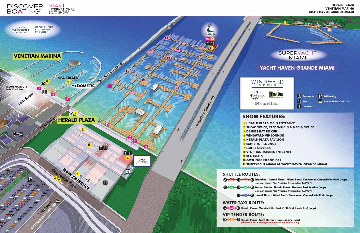

This map was created for the 2025 Miami International Boat Show and represents a refined update of the previous year’s design. It is built from a detailed digital three dimensional model and highlights the primary venues at Venetian Marina and One Herald Plaza. The map also provides geographic context for the Superyacht Miami Show on Watson Island, often known as Yacht Haven Grande, giving visitors a clear sense of how the major show locations relate to one another. Docks and ramps are labeled directly for easy reference, while show features are identified with numbered yellow markers. Amenities are indicated with clear graphical icons, and streets and sponsors are labeled directly within the illustration. Transportation options, including shuttle routes, Water Taxi service, and VIP tender routes, are communicated through a simple and intuitive graphic system.
This map was produced alongside four additional maps, all of which were included in the official show program, including page layout work completed by me. The map was also used across digital platforms, on site signage, and broader marketing materials. At an event of this scale, a clear and well designed wayfinding map is essential. It functions not only as a practical navigation tool, but also as a visual signal of organization, professionalism, and overall event quality.
Miami International Boat Show Maps 2025:
Venetian Marina and One Herald Plaza | Museum Park | Miami Beach Convention Center Map | Transportation Map | Pride Park Map | Program LayoutMiami International Boat Show:
I have worked on illustrated maps and wayfinding graphics for the Miami International Boat Show (also known as MIBS) for many years, supporting one of the largest and most complex boat shows in the world. The show spans multiple waterfront venues across Miami and Miami Beach, including convention spaces, marinas, and on water exhibition areas. This scale presents unique challenges, and clear navigation is essential for both visitors and exhibitors. My role has been to translate that complexity into maps that are easy to understand while still feeling polished, professional, and appropriate for a premier international event.
Each year the Miami International Boat Show evolves. Dock layouts shift, exhibitor locations change, venues are added or removed, and sponsorship requirements are updated. I routinely revise and rebuild maps to reflect these changes accurately, often under tight deadlines. My approach emphasizes a strong visual hierarchy that allows guests to orient themselves quickly, identify major zones, and then locate specific docks, tents, amenities, and points of interest. This clarity helps reduce confusion and improves the overall guest experience across all show locations.
The illustrated maps I create for the Miami International Boat Show are used in a wide range of formats, including print programs, signage, exhibitor materials, and digital platforms. I rely on consistent systems such as numbered keying for primary destinations and icon based symbols for recurring amenities like restrooms, food areas, transportation, and services. This method minimizes visual clutter and ensures that information remains legible even in dense, information rich environments.
Large scale marine events like the Miami International Boat Show require a careful balance between accuracy, usability, and visual appeal. My experience with boat shows, marinas, and waterfront venues allows me to design maps that serve practical navigation needs while also reinforcing the upscale branding of the event. For organizers, sponsors, and exhibitors, a well designed illustrated map becomes an essential tool that supports crowd flow, improves communication, and enhances the overall perception of the show.
EXAMPLES OF MAPS CREATED FOR MIAMI BOAT SHOWS:


Maps For Boat Shows In Miami:
- About Miami Boat Shows
- Miami International Boat Show / Miami Yacht Show / Yachts Miami Beach / Miami Beach Yacht and Brokerage Show - Show Center/Primary Venue Maps: 2026 | 2025 | 2024 | 2023 | 2022 | 2020 | 2019 | 2018 | 2017 | 2016 | 2015 | 2014 | 2013 | 2012 | 2011
- Transportation Map: 2026 | 2025 | 2024 | 2023 | 2022 | 2020 | 2019 | 2016 | 2013 | 2012
- Program Layout: 2026 | 2025 | 2024 | 2023 | 2022
- Yacht Haven Grande at Island Gardens: 2026 | 2022 | 2020 | 2016
- Miami Beach Convention Center: 2026 | 2025 | 2024 | 2023 | 2022 | 2013 | 2012
- Sea Isle Marina Only: 2013 | 2012
- Miamarina at Bayside Only: 2013 | 2012 | 2011
- Bayfront Park: 2015
- Museum Park Marina: 2025 | 2024 | 2023 | 2022
- Illustration (not a map): 2014
- Video: 2013


EXPLORE MY WORK
- Illustration: Discover custom illustrations, book covers, illustrated maps, and architectural renderings.
- Fine Art: Browse original paintings and drawings, view the Custom Halftone Series, or check out mural projects.
- Graphic Design & Motion: See the graphic design collection, then dive into motion design and animated illustrations.
- Maps by industry: View illustrated maps tailored for boat shows, resorts, marinas, real estate, transportation, towns, parks, and wayfinding.
- More project types: Explore cover art, vehicle wraps, proposal renderings, and street art.
- Techniques & styles: Work spans vector, isometric, painting, black-and-white, GeoData, overhead maps, and halftones.
- Software expertise: Primary tools include Photoshop, Illustrator, SketchUp Pro, and InDesign, plus Premiere Pro & After Effects for motion.