Miami Beach Convention Center Map for the Miami International Boat Show - 2022
Client: Informa Markets
For information about the Miami International Boat Show and to ensure you're seeing the latest maps and information visit MiamiBoatShow.com

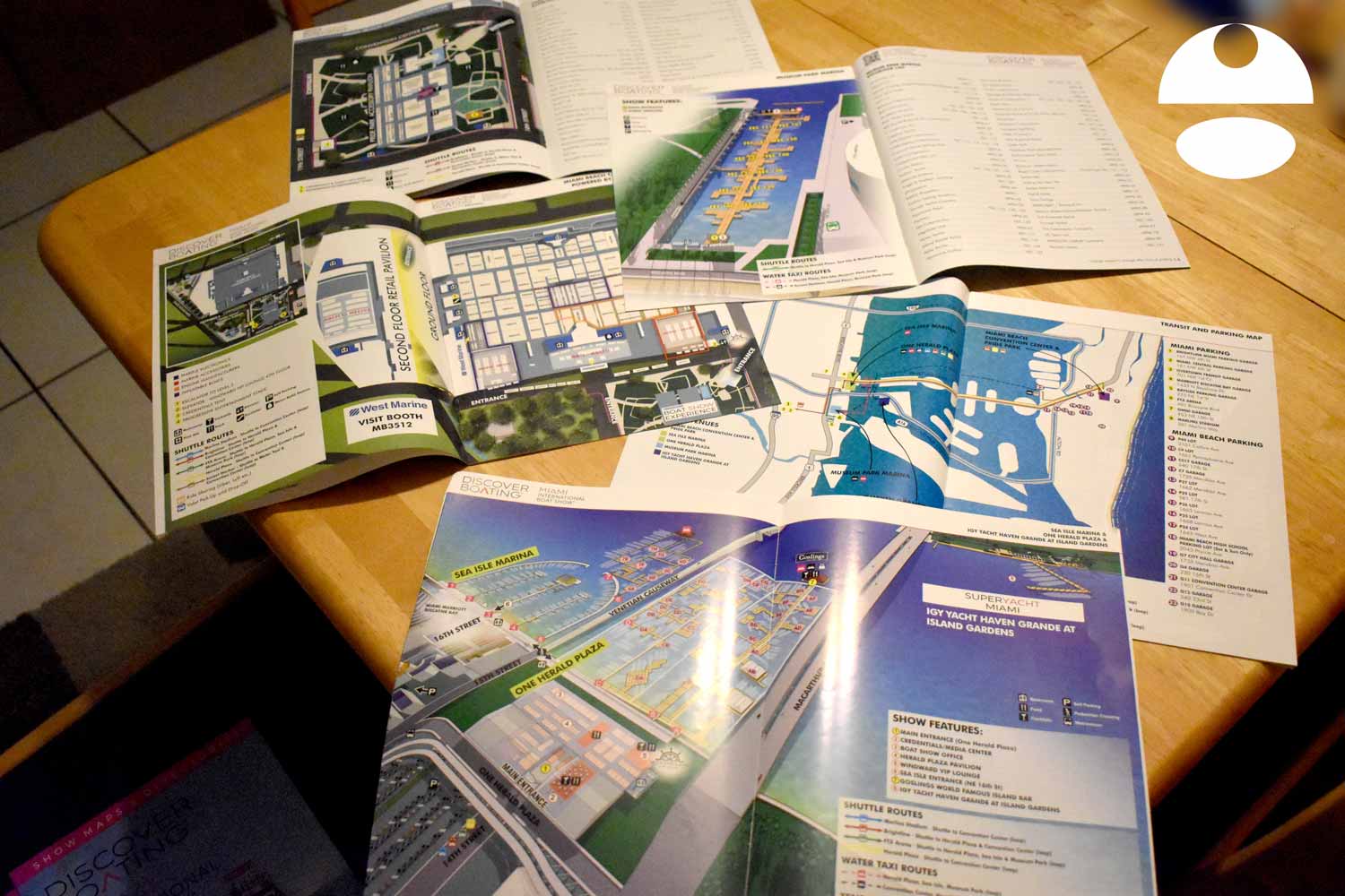
The design intent was to blend the clarity of a traditional overhead map with selected elements of the more illustrative show center maps used elsewhere in the event. It was created as part of a coordinated set of five maps included in the official show program, with Escape Key Graphics also responsible for the overall page layout and production of that publication. This marked a shift toward a fully printed program, replacing earlier formats that relied on large fold out maps to communicate venue and transportation information. In previous years the Venetian Marina and One Herald Plaza map was printed on an oversized folding map printed by Z-CARD North America with the Transportation Map, Superyacht Show map and a detail map of land displays at Venetian Marina and One Herald Plaza map.
The map depicts both the interior of the Miami Beach Convention Center and portions of the surrounding exterior area. The overhead perspective emphasizes simplicity and legibility, while carefully applied color and texture help distinguish between indoor spaces and the outdoor environment. The illustration is fully vector based and intentionally restrained, with limited use of rendered foliage to add visual context without overwhelming the layout. Exhibition areas within the convention center are clearly numbered and labeled, and the floor plan is organized into color coded sectors that are keyed on the map for quick reference.
Important destinations and services are highlighted with numbered markers, while amenities such as restrooms, information desks, and services are identified using clean, easily recognizable icons. Shuttle routes serving the venue are explained through a compact visual legend, allowing visitors to understand transportation options at a glance. The result is a map that balances detail with clarity, supporting both first time visitors and returning attendees.
Beyond the printed program, this map was used across digital platforms, on site signage, and event marketing materials. For an event of this size and complexity, a clear and thoughtfully designed map plays a critical role. It serves not only as a navigation tool, but also as a reflection of the show’s organization, professionalism, and overall quality.
EXAMPLES OF MAPS CREATED FOR MIAMI BOAT SHOWS:


Miami International Boat Show Maps 2022:
Sea Isle Marina and One Herald Plaza | Museum Park | Miami Beach Convention Center Map | Transit and Parking | Pride Park | Yacht Haven Grande at Island Gardens | Program LayoutMaps For Boat Shows In Miami:
- About Miami Boat Shows
- Miami International Boat Show / Miami Yacht Show / Yachts Miami Beach / Miami Beach Yacht and Brokerage Show - Show Center/Primary Venue Maps: 2026 | 2025 | 2024 | 2023 | 2022 | 2020 | 2019 | 2018 | 2017 | 2016 | 2015 | 2014 | 2013 | 2012 | 2011
- Transportation Map: 2026 | 2025 | 2024 | 2023 | 2022 | 2020 | 2019 | 2016 | 2013 | 2012
- Program Layout: 2026 | 2025 | 2024 | 2023 | 2022
- Yacht Haven Grande at Island Gardens: 2026 | 2022 | 2020 | 2016
- Miami Beach Convention Center: 2026 | 2025 | 2024 | 2023 | 2022 | 2013 | 2012
- Sea Isle Marina Only: 2013 | 2012
- Miamarina at Bayside Only: 2013 | 2012 | 2011
- Bayfront Park: 2015
- Museum Park Marina: 2025 | 2024 | 2023 | 2022
- Illustration (not a map): 2014
- Video: 2013


PORTFOLIO GALLERIES
- Illustration work: Start with custom illustration and cover design, then view illustrated maps and architectural renderings.
- Fine art: Discover original paintings and drawings, the Custom Halftone Series, and mural projects.
- Design & motion: Check out the graphic design gallery, then move on to motion graphics and animated illustration.
- Maps by sector: I produce illustrated maps for boat shows, resorts, marinas, real estate, transit & parking, towns & cities, parks, and wayfinding systems.
- More creative services: Additional offerings include cover illustration, vehicle wraps, proposal renderings, and street art.
- Artistic methods: My work spans vector art, isometric & axonometric views, traditional painting, black & white illustration, GeoData mapping, overhead perspectives, and halftone effects.
- Preferred software: I rely on Photoshop, Illustrator, SketchUp Pro, and InDesign, plus Premiere Pro & After Effects for motion projects.