Parking and Transportation Map for the Miami International Boat Show - 2022 - Version in the Show Program
Client: Informa Markets
For information about the Miami International Boat Show and to ensure you're seeing the latest maps and information visit MiamiBoatShow.com
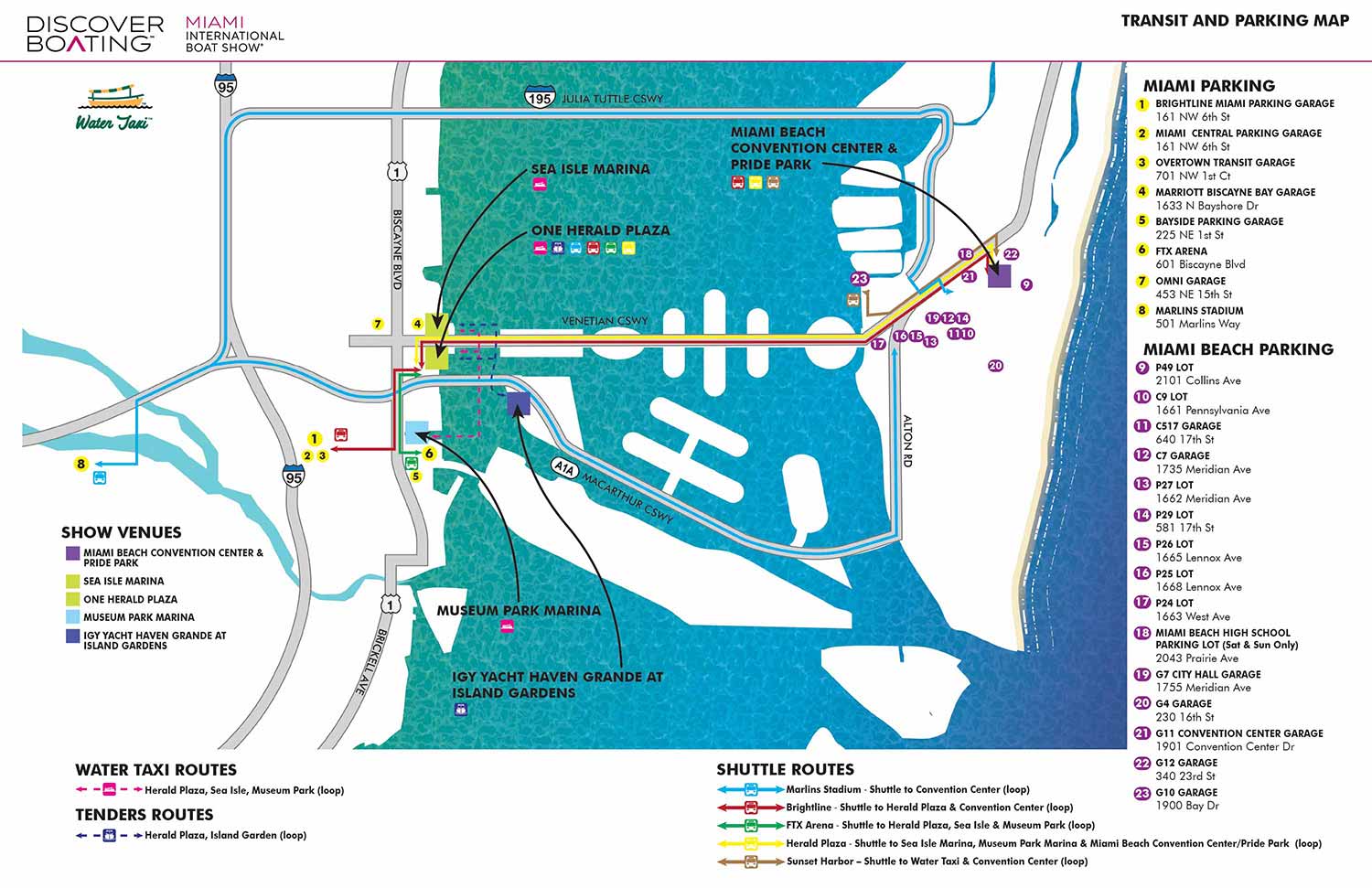
The 2022 Miami International Boat Show introduced a newly formatted Transit and Parking map, representing a significant step forward in clarity and usability. Designed to simplify complex logistics, this map serves as an essential tool for an event with dedicated transportation systems and multiple show venues.
Presented as an overhead, street-style illustration, the map clearly communicates shuttle routes and stops, as well as water taxi boarding locations, helping attendees move efficiently between Miami and Miami Beach. Parking areas are indicated visually, while addresses for GPS navigation are provided in accompanying text for convenience.
Show venues, shuttle routes, and water taxi routes are colour coded and reinforced with a simple, intuitive icon system. Major roadways are included to guide drivers, creating a cohesive overview that combines a large amount of logistical information in a clean and easy-to-read format.
While the design prioritizes simplicity for the viewer, it required multiple dedicated versions for the official program, on-site signage, and the web. The result is a practical, well-structured planning tool that allows visitors to navigate the event with confidence and spend more time enjoying the show.
Miami International Boat Show:
I have worked on illustrated maps and wayfinding graphics for the Miami International Boat Show (also known as MIBS) for many years, supporting one of the largest and most complex boat shows in the world. The show spans multiple waterfront venues across Miami and Miami Beach, including convention spaces, marinas, and on water exhibition areas. This scale presents unique challenges, and clear navigation is essential for both visitors and exhibitors. My role has been to translate that complexity into maps that are easy to understand while still feeling polished, professional, and appropriate for a premier international event.
Each year the Miami International Boat Show evolves. Dock layouts shift, exhibitor locations change, venues are added or removed, and sponsorship requirements are updated. I routinely revise and rebuild maps to reflect these changes accurately, often under tight deadlines. My approach emphasizes a strong visual hierarchy that allows guests to orient themselves quickly, identify major zones, and then locate specific docks, tents, amenities, and points of interest. This clarity helps reduce confusion and improves the overall guest experience across all show locations.
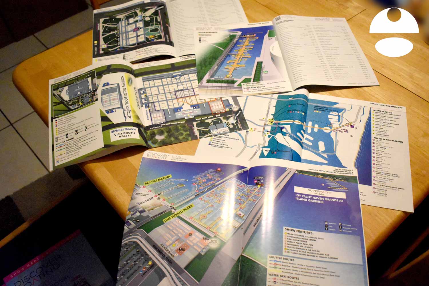
The illustrated maps I create for the Miami International Boat Show are used in a wide range of formats, including print programs, signage, exhibitor materials, and digital platforms. I rely on consistent systems such as numbered keying for primary destinations and icon based symbols for recurring amenities like restrooms, food areas, transportation, and services. This method minimizes visual clutter and ensures that information remains legible even in dense, information rich environments.
Large scale marine events like the Miami International Boat Show require a careful balance between accuracy, usability, and visual appeal. My experience with boat shows, marinas, and waterfront venues allows me to design maps that serve practical navigation needs while also reinforcing the upscale branding of the event. For organizers, sponsors, and exhibitors, a well designed illustrated map becomes an essential tool that supports crowd flow, improves communication, and enhances the overall perception of the show.
Miami International Boat Show Maps 2022:
Sea Isle Marina and One Herald Plaza | Museum Park | Miami Beach Convention Center Map | Transit and Parking | Pride Park | Yacht Haven Grande at Island Gardens | Program LayoutEXAMPLES OF MAPS CREATED FOR MIAMI BOAT SHOWS:


Maps For Boat Shows In Miami:
- About Miami Boat Shows
- Miami International Boat Show / Miami Yacht Show / Yachts Miami Beach / Miami Beach Yacht and Brokerage Show - Show Center/Primary Venue Maps: 2026 | 2025 | 2024 | 2023 | 2022 | 2020 | 2019 | 2018 | 2017 | 2016 | 2015 | 2014 | 2013 | 2012 | 2011
- Transportation Map: 2026 | 2025 | 2024 | 2023 | 2022 | 2020 | 2019 | 2016 | 2013 | 2012
- Program Layout: 2026 | 2025 | 2024 | 2023 | 2022
- Yacht Haven Grande at Island Gardens: 2026 | 2022 | 2020 | 2016
- Miami Beach Convention Center: 2026 | 2025 | 2024 | 2023 | 2022 | 2013 | 2012
- Sea Isle Marina Only: 2013 | 2012
- Miamarina at Bayside Only: 2013 | 2012 | 2011
- Bayfront Park: 2015
- Museum Park Marina: 2025 | 2024 | 2023 | 2022
- Illustration (not a map): 2014
- Video: 2013


PORTFOLIO SELECTIONS
- Custom illustration & covers: Featuring bespoke illustration, book and magazine covers, hand-drawn maps, and building renderings.
- Fine art & murals: Including one-of-a-kind paintings and drawings, the Custom Halftone Series, and large-scale murals.
- Design & motion media: Covering graphic design, plus video and motion and animated illustration.
- Mapping by application: Tailored maps for marine events, hospitality, waterfront, property, transit, municipal, recreation, and navigation needs.
- Additional creative work: Includes editorial covers, vehicle graphics, concept renderings, and public art.
- Mediums & formats: Ranging from digital vector and isometric projection to traditional paint, line art, GIS-based, aerial-style, and halftone.
- Software expertise: Proficient in Photoshop, Illustrator, SketchUp, InDesign, and Premiere/After Effects for motion.