Show Proposal Illustration
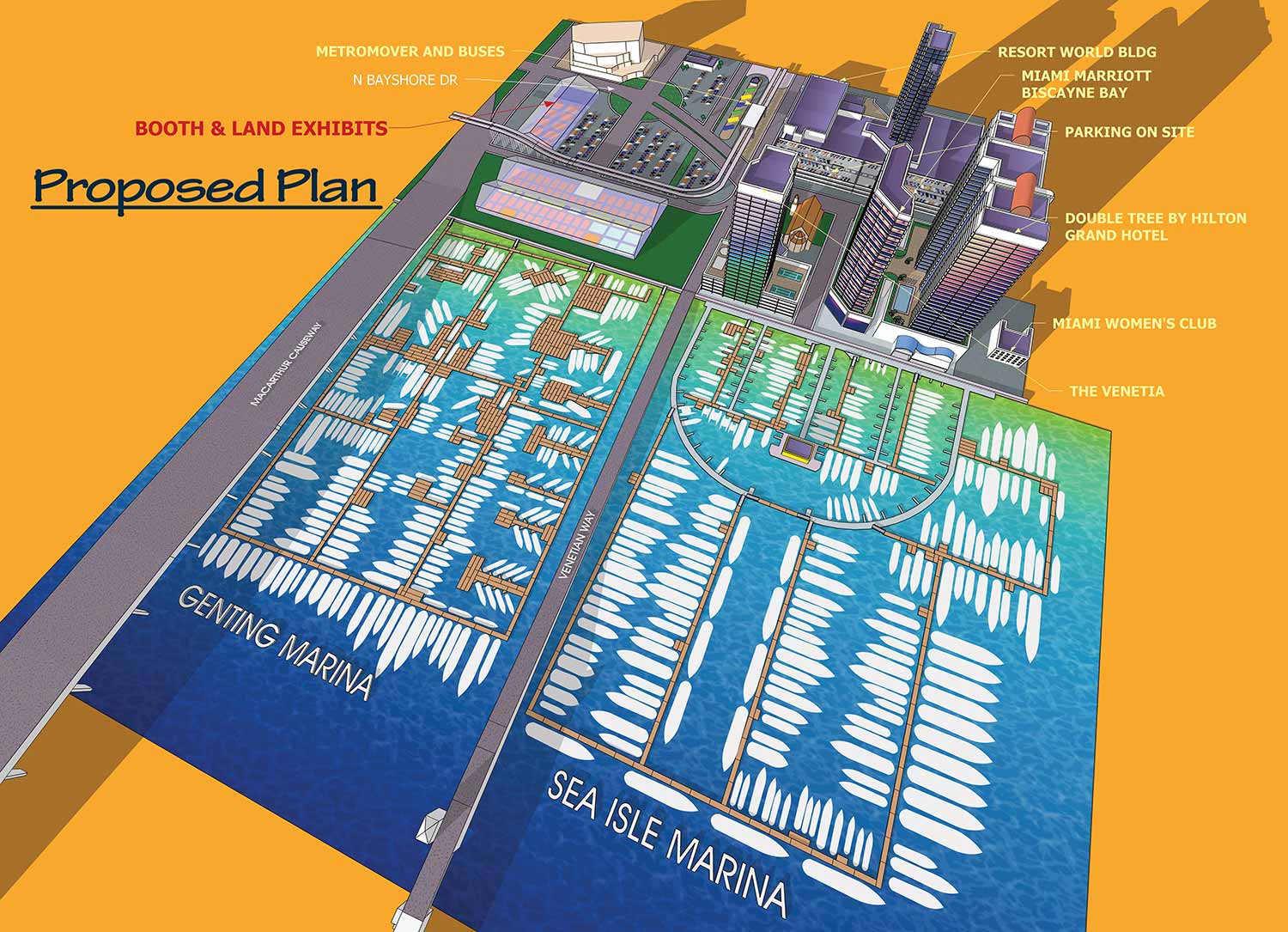
I was approached not long ago by Informa's management to create a rendering for a proposal to move the venue of the Miami Yacht Show from its venue on Collins Avenue in North Miami Beach to a little north of downtown Miami. The new location was to include Sea Isle Marina and the yet to be created Genting Marina. The show will be near the Adrienne Arsht Center for the Performing Arts and the Venetian and MacArthur Causeways.
I had previously rendered the Sea Isle Marina for another illustration so I was familiar with the area. After a little back and forth with some revisions we settled on the finished rendering you see here. The illustration was a success because Informa has announced that they will be moving to the new venue in 2019.
The new venue will provide access to the cultural, dining and general conveniences of downtown Miami plus increased parking capacity to over 3,500 spots. Close proximity of venues should increase the efficiency of Water Taxi service as well. The deeper water will also accommodate larger yachts with deeper drafts.
PROPOSAL RENDERINGS:
I've been called upon many times to create drawings, art or renderings for proposals. This work spans new construction, interiors design and all kinds of other stuff that never ceases to surprise me. Proposals for investment or to convey an idea to a board may need to be realistic or sketchy and vague depending on the client's needs. I can accommodate both situations. I frequently use the same software as architectural firms use to make these renderings so you can provide your potential financiers with a professional presentation in a style they're comfortable with. Sometimes the presentation of a nice piece of proposal artwork is all that stands between your idea staying a dream and the funding needed to get it done. I'm here to help.
WHAT IS SKETCHUP?:
SketchUp, originally developed by Google and now maintained by Trimble Inc., is a powerful 3D modeling program widely used across architecture, interior design, marine architecture, civil and mechanical engineering, and even film and video game production. While it is not intended for character design or organic modeling, SketchUp excels at creating precise, technical models using basic shapes, making it ideal for architectural renderings, site planning, and technical illustrations.
I first began using SketchUp in 2012 while creating the illustrated map for the St. Petersburg Power and Sailboat Show. At the time, I was seeking an efficient alternative to isometric drawing for map illustration. Since then, I have expanded its use across a variety of projects and now rely on SketchUp almost daily to create accurate, visually compelling 3D models for maps, buildings, and other technical illustrations.
SketchUp allows me to combine technical precision with artistic flexibility. Models created in SketchUp can be used as the foundation for detailed illustrations, integrated with Adobe Illustrator or Photoshop, or exported for presentation and visualization purposes. Its versatility makes it a valuable tool for projects that require accurate spatial representation, clear perspective, and a professional, polished look.
If you are interested in having a custom model or illustration created in SketchUp, please contact me for a quote. I can provide solutions for everything from complex architectural layouts to 3D maps and technical renderings tailored to your specific project needs.
PORTFOLIO SELECTIONS
- Custom illustration & covers: Featuring bespoke illustration, book and magazine covers, hand-drawn maps, and building renderings.
- Fine art & murals: Including one-of-a-kind paintings and drawings, the Custom Halftone Series, and large-scale murals.
- Design & motion media: Covering graphic design, plus video and motion and animated illustration.
- Mapping by application: Tailored maps for marine events, hospitality, waterfront, property, transit, municipal, recreation, and navigation needs.
- Additional creative work: Includes editorial covers, vehicle graphics, concept renderings, and public art.
- Mediums & formats: Ranging from digital vector and isometric projection to traditional paint, line art, GIS-based, aerial-style, and halftone.
- Software expertise: Proficient in Photoshop, Illustrator, SketchUp, InDesign, and Premiere/After Effects for motion.