Illustrated Visitor's Map of a Town
Client: Theodore Roosevelt Medora Foundation
For more information on visiting Medora, ND please visit Medora.com
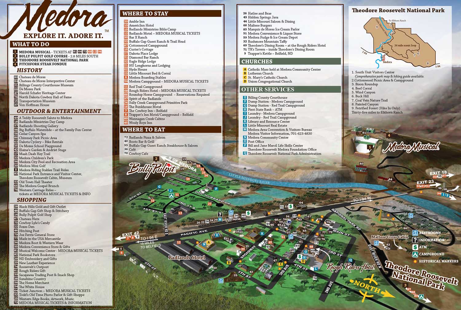
This illustrated city map of Medora, North Dakota was commissioned by the Theodore Roosevelt Medora Foundation to guide visitors and showcase one of the most unique destinations in the American West. Nestled in the North Dakota Badlands, Medora is celebrated for its historic charm, striking landscapes, and attractions rooted in cowboy and Old West heritage. The Medora Musical remains a signature draw, bringing visitors from across the country, and the map was designed to enhance tourism by making the town intuitive and enjoyable to explore.
From the outset, a three-dimensional modeling approach proved more effective for this project than a traditional isometric style. Medora’s varied terrain, surrounding bluffs, and rolling hills offered an opportunity to use depth and perspective, creating a map that is both engaging and informative. The three-dimensional workflow allowed for extensive experimentation with viewing angles and compositions, resulting in over twenty iterations before arriving at the final layout that balanced accuracy, readability, and visual appeal.
The distinctive geography of the Badlands became a central element of the illustration. Elevation changes, hills, and rock formations were emphasized to give viewers a strong sense of place while keeping the town’s layout clear and legible. Skyline features and foreground bluffs were added later to frame the scene, enhancing visual interest without detracting from navigational clarity.
Illustrated city maps like this serve as powerful tools for tourism organizations, visitor centers, and cultural destinations. They blend practical wayfinding with storytelling, helping visitors feel oriented while sparking excitement for exploration. This Medora map demonstrates how careful illustration and spatial design can elevate the visitor experience while supporting a destination’s branding and outreach efforts.
2018 map with key | 2016 map with key | 2015 map with key| Illustration without map key


PORTFOLIO SELECTIONS
- Custom illustration & covers: Featuring bespoke illustration, book and magazine covers, hand-drawn maps, and building renderings.
- Fine art & murals: Including one-of-a-kind paintings and drawings, the Custom Halftone Series, and large-scale murals.
- Design & motion media: Covering graphic design, plus video and motion and animated illustration.
- Mapping by application: Tailored maps for marine events, hospitality, waterfront, property, transit, municipal, recreation, and navigation needs.
- Additional creative work: Includes editorial covers, vehicle graphics, concept renderings, and public art.
- Mediums & formats: Ranging from digital vector and isometric projection to traditional paint, line art, GIS-based, aerial-style, and halftone.
- Software expertise: Proficient in Photoshop, Illustrator, SketchUp, InDesign, and Premiere/After Effects for motion.