Illustrated Guide Map of a Town
Client: Theodore Roosevelt Medora Foundation
2018 map with key | 2016 map with key | 2015 map with key| Illustration without map key
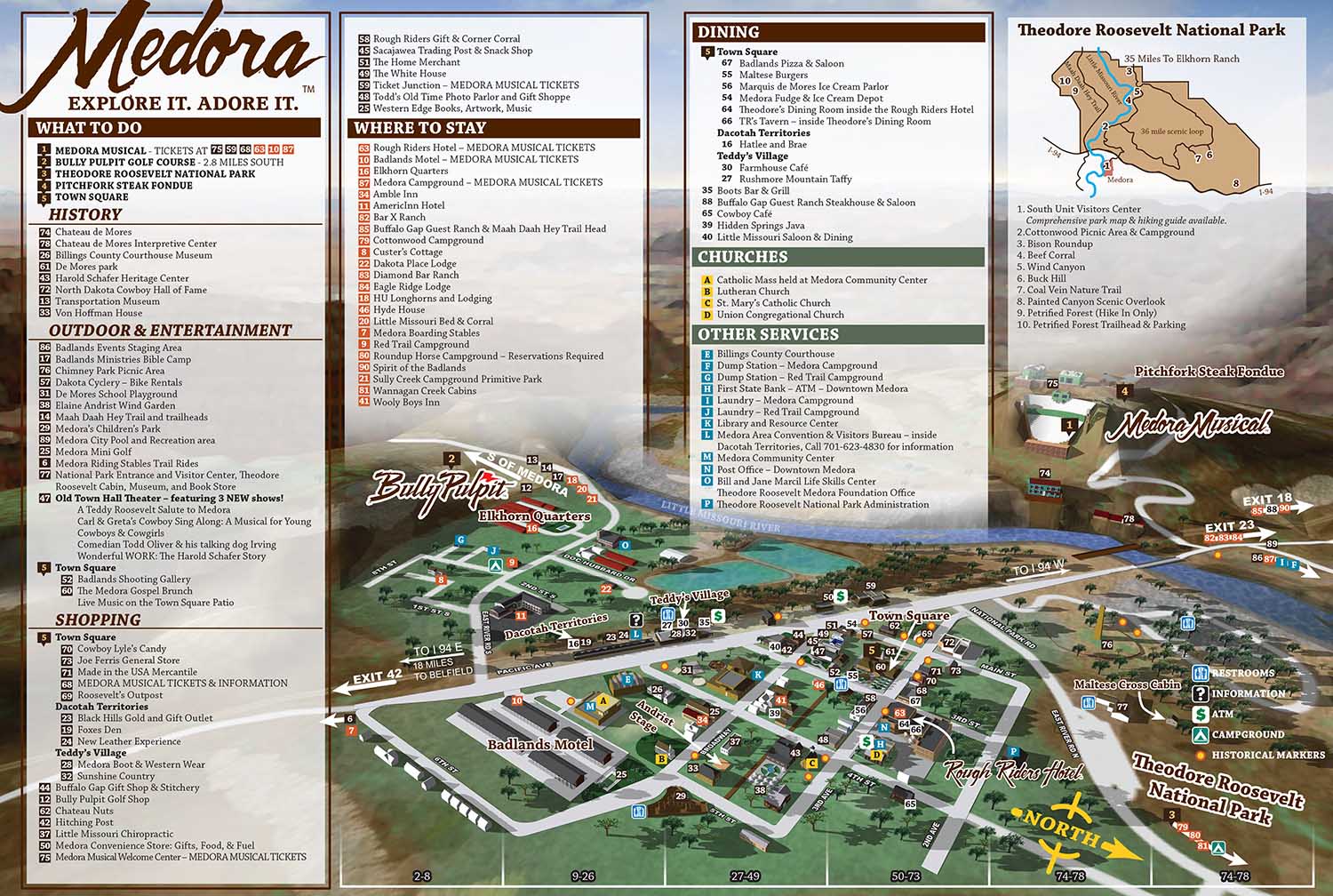
This illustrated city map of Medora, North Dakota was created for the Theodore Roosevelt Medora Foundation to help visitors navigate and experience one of the most distinctive destinations in the American West. Located in the North Dakota Badlands, Medora is known for its historic character, dramatic landscape, and popular attractions rooted in cowboy and Old West culture. The Medora Musical remains one of the town’s biggest draws, attracting visitors from across the country, and the map was designed to support tourism by making the town easy to understand and explore.
From the beginning, it was clear that a three dimensional modeling approach would be better suited to this project than a traditional isometric illustration. Medora’s varied terrain, surrounding bluffs, and rolling hills presented an opportunity to use depth and perspective to create a more engaging and informative map. The flexibility of a three dimensional workflow allowed me to test many viewing angles and compositions before arriving at the final perspective. More than twenty variations were explored to ensure the layout balanced clarity, accuracy, and visual appeal.
The unique geography of the Badlands became a central feature of the illustration. Elevation changes, hills, and rock formations were emphasized to give viewers a strong sense of place while still keeping the town layout easy to read. The skyline and foreground bluff elements were added later in the process and helped frame the scene, adding visual interest without distracting from wayfinding.
Illustrated city maps like this are valuable tools for tourism organizations, visitor centers, and cultural destinations. They combine practical navigation with storytelling, helping visitors feel oriented and excited about exploring a place. This Medora map demonstrates how thoughtful illustration and spatial design can enhance the visitor experience while supporting branding and outreach goals for a destination.
(and maps of similar areas)


TOWN, CITY & NEIGHBORHOOD MAPS:
I've have created many illustrated maps over the years showing downtowns, neighborhoods and sometimes whole cities. These maps vary in nature based on the area involved. Most span an area of a few city blocks or the equivalent. At that scale I can include a fair amount of detail and use accurate scales for buildings and such and you can still tell what you are looking at clearly. In a smaller area I can provide even more detail to the illustration, but when you need to see many, many city blocks I usually have to switch to a less literal rendering approach. I may have to take license with exaggerated scales of buildings or cartoon like renderings of points of interest. This makes for a less literal illustrated map.
With the first scale of maps at a few city blocks I have a standard, tried and true method that I've used many times. This is not to say that I am inflexible or not open to new ideas but generally speaking I can get down to work right away on one of these maps without much conversation. Assuming, of course, that the client wants a similar illustrated map to previous ones I've made.
With the larger scale maps the client has many options right off and I need to ensure that I give them what they want. This necessitates a little more conversation and consulting before I begin.I also create overhead maps including street maps. These range from the simplified to the extremely detailed. Now using Geodata (computerized geographical data that can be used to create maps and add information to those maps) I can add levels of detail, and accuracy that would have been impossible (for me at least) a few years ago.
PORTFOLIOS
- Illustration Portfolio: Start here for custom illustration and book covers. You can also browse illustrated maps and architectural rendering.
- Fine Art: I offer original paintings and drawings, including my Custom Halftone Series. You will also find mural work here.
- Graphic Design & Motion: View my graphic design portfolio. After that, explore motion design and animated illustrations.
- Maps by application: I create illustrated maps for boat shows, resorts, marinas, real estate, transportation, transit and parking, towns and cities, parks, and wayfinding.
- Additional project types: I also produce cover illustration, vehicle and vinyl wraps, proposal renderings, and street art.
- Illustration methods: My techniques include vector, isometric and axonometric, painting, black and white, GeoData maps, overhead maps, and custom halftones.
- Software portfolios: I work primarily in Adobe Photoshop, Adobe Illustrator, SketchUp Pro, and Adobe InDesign. For motion projects, I use Premiere Pro and After Effects.