Illustrated Boat Show Guest Map
Client: The Newport Exhibition Group
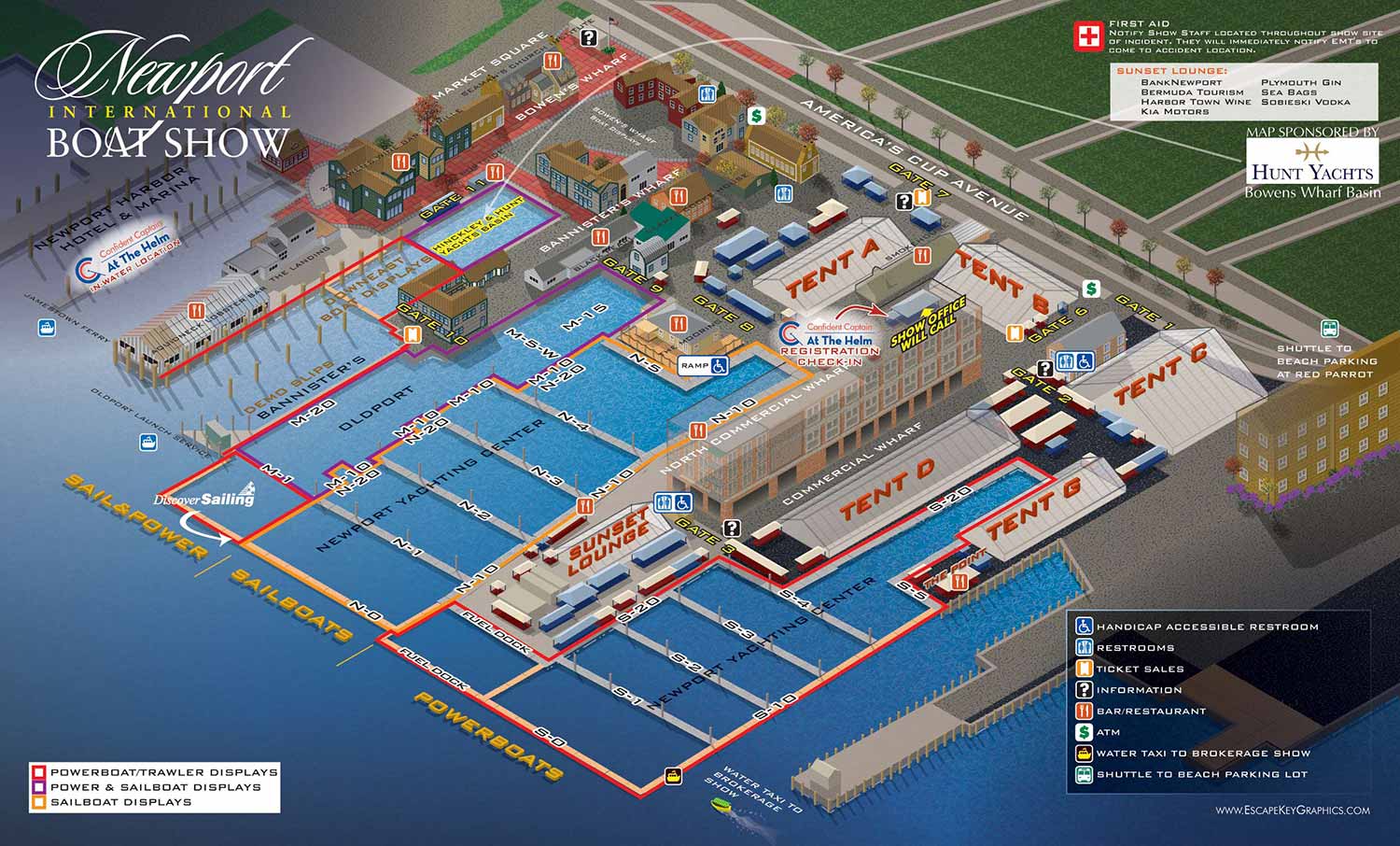
At the client’s request, this revision leans heavily on clear labeling rather than relying on a keyed system. Docks, exhibit tents, and major landmarks are directly labeled to make the layout immediately understandable, while amenities are identified with a consistent set of graphical icons. This combination of direct labeling and symbolic representation ensures that both first-time visitors and returning attendees can quickly orient themselves. The isometric perspective, viewed from the harbor looking inland, gives the map an aerial quality that captures the scope of the event while retaining a clear sense of scale and spatial relationships.
To improve readability and enhance visual appeal, different types of boat displays are color-coded by zone, such as areas dedicated solely to sailboats. The palette is intentionally earthy and muted, reflecting the natural tones of Newport’s harbor and the surrounding New England landscape. This approach reinforces a sense of place, making the map not only functional but also visually aligned with the region’s maritime character. Visitors can intuitively distinguish between sections of the show while enjoying an illustration that feels both elegant and approachable.
Beyond navigation, these maps serve as valuable marketing tools for the Newport International Boat Show. A well-crafted illustrated map communicates professionalism, attention to detail, and a strong sense of organization, which enhances the visitor experience and encourages engagement. For organizers, exhibitors, and sponsors, the map becomes more than a guide—it is a branded asset that strengthens the show’s presence online, in print, and on site. This project demonstrates how thoughtful illustration can combine clarity, aesthetic appeal, and practical functionality to elevate a major waterfront event.
Maps For Newport International Boat Show:
EXPLORE MY PORTFOLIOS
- Illustration: Find custom illustration, book covers, illustrated maps, and architectural rendering.
- Fine Art: Browse original paintings and drawings, the Custom Halftone Series, and murals.
- Graphic Design & Motion: See my graphic design work, plus motion design and animated illustrations.
- Maps by industry: Illustrated maps tailored for boat shows, resorts, marinas, real estate, transit & parking, towns & cities, parks, and wayfinding.
- Other project types: Also available: cover art, vehicle & vinyl wraps, proposal renderings, and street art.
- Techniques: Explore work in vector, isometric & axonometric, painting, black & white, GeoData, overhead, and halftone styles.
- Software: Primary tools: Photoshop, Illustrator, SketchUp Pro, and InDesign. Motion work uses Premiere Pro & After Effects.