Convention Center Site Plan for Exhibitors and Guests 2022: A Clear Vision for the Future
Design by John Potter - Escape Key Graphics
Client: Informa Markets
Client: Informa Markets
Visit their official site at FLIBS.com for information on the show and more up to date information.
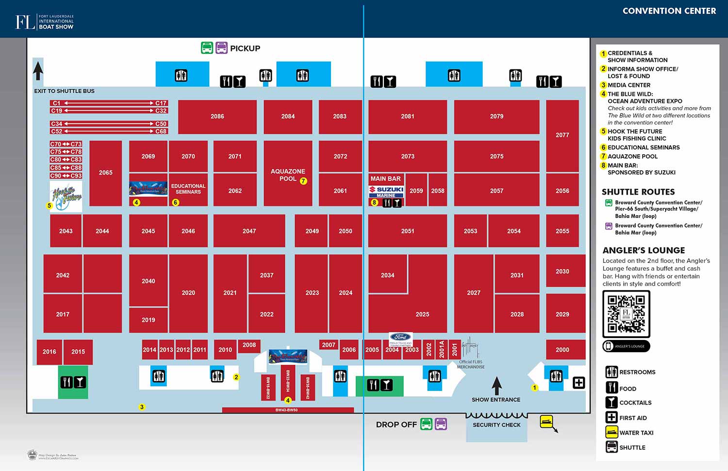
The 2022 Broward County Convention Center site plan for the Fort Lauderdale International Boat Show (FLIBS) marked a significant reinvention following a two year hiatus. This period provided an opportune moment to fundamentally reimagine the map's design, moving decisively away from the three dimensional aesthetic that had been gradually simplified over previous versions. In its place, we adopted a clean, diagrammatic approach built on crisp vector graphics. This streamlined visual language aligned perfectly with the modernized headers introduced in 2019, resulting in a cohesive and contemporary presentation for the show's official materials.
The core concept for indicating exhibitor space remained functionally intact despite the shift from 3D to 2D. The convention center floor was represented as a light blue field, with individual exhibitor areas clearly defined by bold red rectangles. Exhibitor spaces were still accurately labeled with numbers or number spans for easy reference. A key organizational change was the consolidation of all menus and keys into a single, orderly sidebar, which contributed significantly to the map's uncluttered and professional appearance. The system of yellow dots with black text for key points of interest was retained, and the set of graphical icons for amenities was expanded to now include representations for the various shuttle routes, replacing the previous illustrations of buses.
2022 was also my first year handling the complete page layout for the official show program, coinciding with the retirement of the standalone Z Card folding maps. This shift in primary format directly influenced the design approach. The visual priority became optimizing the map for its presentation as a clear, legible double page spread within the program, even though the final asset would be repurposed across multiple platforms including the event's mobile app, on site signage, digital marketing, and online use.
In the critical planning and promotion phase before an event, organizers often rely on stock photography and generic bold graphics. While visually striking, these elements cannot accurately depict or inform about an event that has not yet occurred. A professionally crafted, detailed map uniquely serves this purpose. It transcends the limitations of time by providing a precise and authoritative preview of the event's layout and scale. This transforms the map from a simple navigational aid into a powerful marketing tool that genuinely informs potential attendees, exhibitors, and sponsors. It builds anticipation through clarity and substance, demonstrating a level of organization and professionalism that generic promotional graphics simply cannot match. When leveraged strategically, a custom illustrated map is not just a guide for the event day; it is a foundational piece of pre event communication that builds confidence and excitement.
This redesigned map represents a new chapter in the convention center series. To see the previous 3D design it evolved from, you can explore projects from earlier years within my Maps Portfolio.
To discuss how a custom site plan can serve as a central marketing and navigational tool for your next event, please contact me to start a conversation.


