2015 Fort Lauderdale International Boat Show Map: Refining the Landscape
Client: Show Management
For information about the Fort Lauderdale International Boat Show visit FLIBS.com
Client: Showboats Magazine

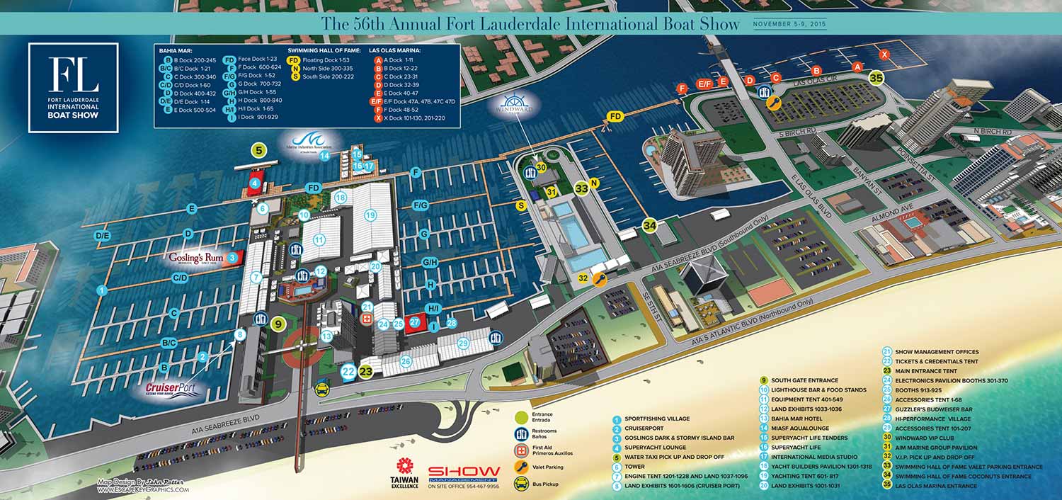
The 2015 Fort Lauderdale International Boat Show (FLIBS) map continued the annual tradition of precise updates within an evolving visual framework. This iteration focused on subtle stylistic refinements that enhanced the map's realism and clarity, moving it toward a more literal representation of the event landscape.
Production began with the essential updates to dock configurations and exhibitor tent placements, ensuring the map accurately reflected the current year's layout. The most notable visual shift was the removal of the faint tabletop style edges that had been present in previous versions. This change eliminated the last suggestion of an artificial boundary, allowing the illustration to present itself more fully as an aerial view of the actual venue.
To further this realistic effect and add a sense of atmosphere, I introduced subtle, thin clouds into the sky above the map. These elements, combined with the refined perspective, made the 2015 edition feel more integrated and immersive as a snapshot of the show grounds.


A Centralized Navigational Tool
During this period, the show distributed its primary visitor information through a foldout map format, printed by Z Card North America, rather than a multipage program. This design made the illustrated map the central, indispensable guide for all attendees. Its utility was extended beyond the handheld piece, as sections of the map were also utilized on signage within exhibitor tents to help visitors orient themselves within the larger venue.
The scope of work for the 2015 show encompassed a full suite of navigational graphics. In total, I designed and illustrated seven distinct maps and four directional signs, creating a cohesive visual system that supported wayfinding across the entire event site from the convention center to the multiple marina locations.
This project highlights the iterative nature of long term client work, where each year builds upon the last. The 2015 map represents a conscious step toward a cleaner, more realistic aesthetic, while maintaining the rigorous accuracy and user friendly design required for one of the world's premier boat shows.
This map is part of an ongoing annual series. To see the design evolution, you can view the previous year's map for FLIBS 2014.
For more examples of complex event cartography and environmental graphics, please visit my full Maps Portfolio.
Fort Lauderdale International Boat Show Maps:
- About Fort Lauderdale International Boat Show
- Bahia Mar, Swimming Hall of Fame & Las Olas Marina Maps: 2025 | 2024 | 2023 | 2022 | 2020 | 2019 | 2018 | 2017 | 2016 | 2015 | 2014 | 2013 | 2012 | 2011 | 2010
- Parking and Transportation Maps: 2025 | 2024 | 2023 | 2022 | 2020 | 2019 | 2018 | 2015 Bus | 2015 Water Taxi | 2014 | 2013 | 2012 | 2011
- Broward County Convention Center Maps: 2025 | 2024 | 2023 | 2022 | 2017 Sailfish Pavilion | 2017 | 2016 Sailfish Pavilion | 2016 | 2015 Sailfish Pavilion | 2015 | 2014 Sailfish Pavilion | 2014 | 2013 Sailfish Pavilion | 2013 | 2012 | 2011 | 2010
- Marinas Maps: 2025 | 2024 | 2023 | 2022 | 2019 | 2016
- Program Layouts: 2025 | 2024 | 2023 | 2022
- Signs: 2013 looking north | 2013 Yachting Tent
- Video: 2013 54th Annual
- Illustrations (not maps): 2014A | 2014B


