Broward County Convention Center 2011 Map: Refining a Navigational Tool
Client: Show Management
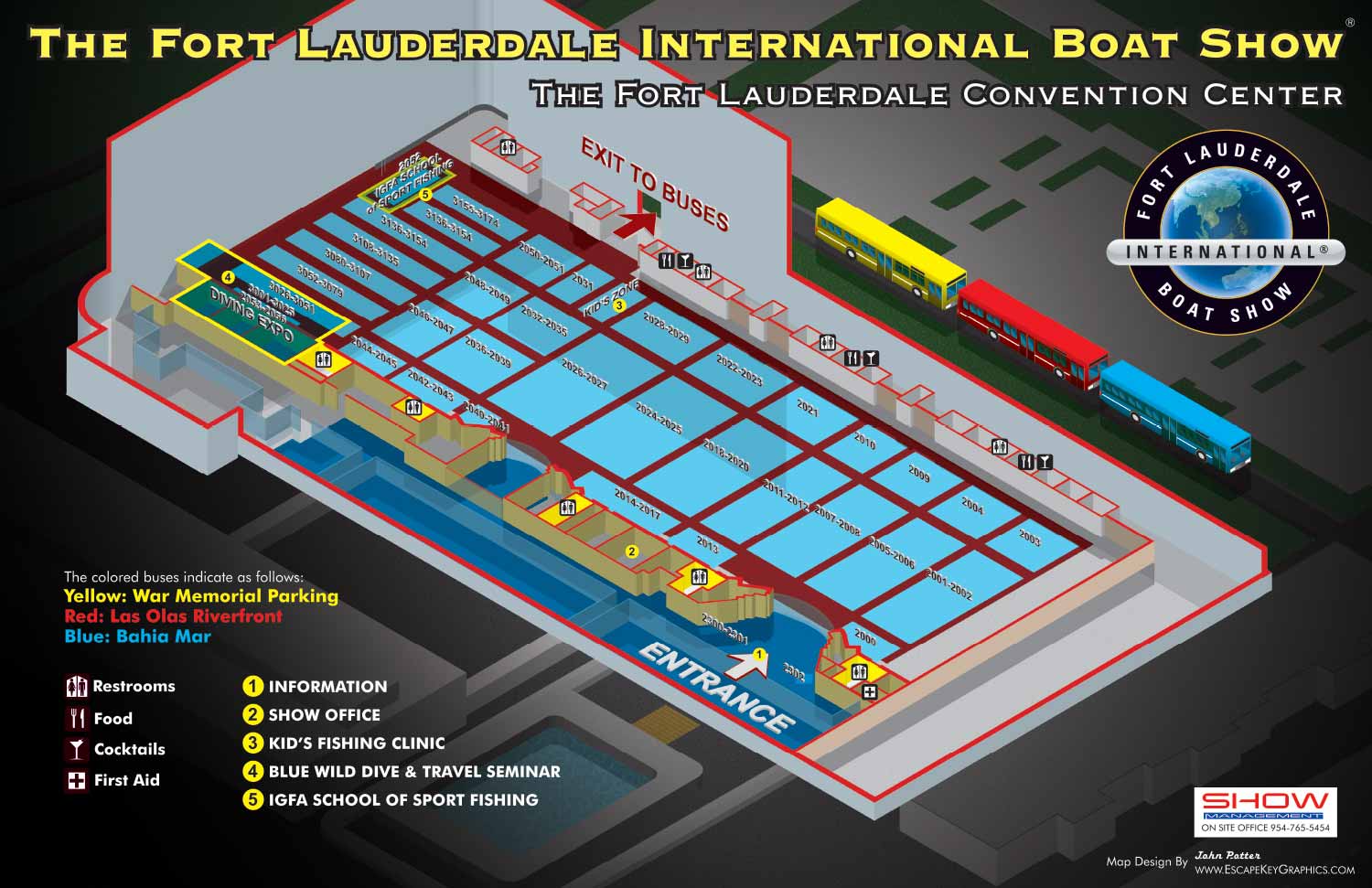
Broward County Convention Center Visitor's Map for the Fort Lauderdale International Boat Show
This 2011 map of the Broward County Convention Center continues the illustrative cartography work for the Fort Lauderdale International Boat Show, building directly upon the foundation established the previous year. The primary task involved updating the exhibitor numbering and the precise footprints of exhibit spaces to reflect the current year's layout, ensuring the map remained an accurate and essential guide for attendees.
A distinctive visual treatment was developed for the convention hall floor. The space was represented as a field of red, evoking the idea of wall to wall carpeting. Upon this field, individual exhibitor footprints were clearly indicated as light blue rectangles, creating a clear and intuitive graphic metaphor that helped visitors quickly distinguish between open aisles and occupied exhibit spaces.
While maintaining the established keying methods for amenities and points of interest to leverage user familiarity, several important enhancements were made. The main entrance to the hall was given a bold, graphic indication, making it immediately identifiable, a crucial improvement for orienting thousands of visitors. Additionally, two major features, The Diving School and the IGFA School of Sportfishing, were specifically called out on the map. This addition highlighted these significant attractions, improving the map's utility as both a navigational tool and a promotional guide to the show's offerings.
This iteration demonstrates the iterative nature of effective design for annual events. By preserving successful elements from the 2010 map while introducing targeted refinements for clarity and emphasis, the 2011 version struck a balance between consistency and improvement, reinforcing its role as a reliable part of the attendee experience.
This project is part of a multi year series. To see the initial design that established this visual approach, please visit the Broward Convention Center 2010 Map.
To explore more examples of detailed event cartography and environmental graphics, please visit my full Map Portfolio.
Fort Lauderdale International Boat Show Maps:
- About Fort Lauderdale International Boat Show
- Bahia Mar, Swimming Hall of Fame & Las Olas Marina Maps: 2025 | 2024 | 2023 | 2022 | 2020 | 2019 | 2018 | 2017 | 2016 | 2015 | 2014 | 2013 | 2012 | 2011 | 2010
- Parking and Transportation Maps: 2025 | 2024 | 2023 | 2022 | 2020 | 2019 | 2018 | 2015 Bus | 2015 Water Taxi | 2014 | 2013 | 2012 | 2011
- Broward County Convention Center Maps: 2025 | 2024 | 2023 | 2022 | 2017 Sailfish Pavilion | 2017 | 2016 Sailfish Pavilion | 2016 | 2015 Sailfish Pavilion | 2015 | 2014 Sailfish Pavilion | 2014 | 2013 Sailfish Pavilion | 2013 | 2012 | 2011 | 2010
- Marinas Maps: 2025 | 2024 | 2023 | 2022 | 2019 | 2016
- Program Layouts: 2025 | 2024 | 2023 | 2022
- Signs: 2013 looking north | 2013 Yachting Tent
- Video: 2013 54th Annual
- Illustrations (not maps): 2014A | 2014B


