Fort Lauderdale International Boat Show Transit Map
Client: Show Management
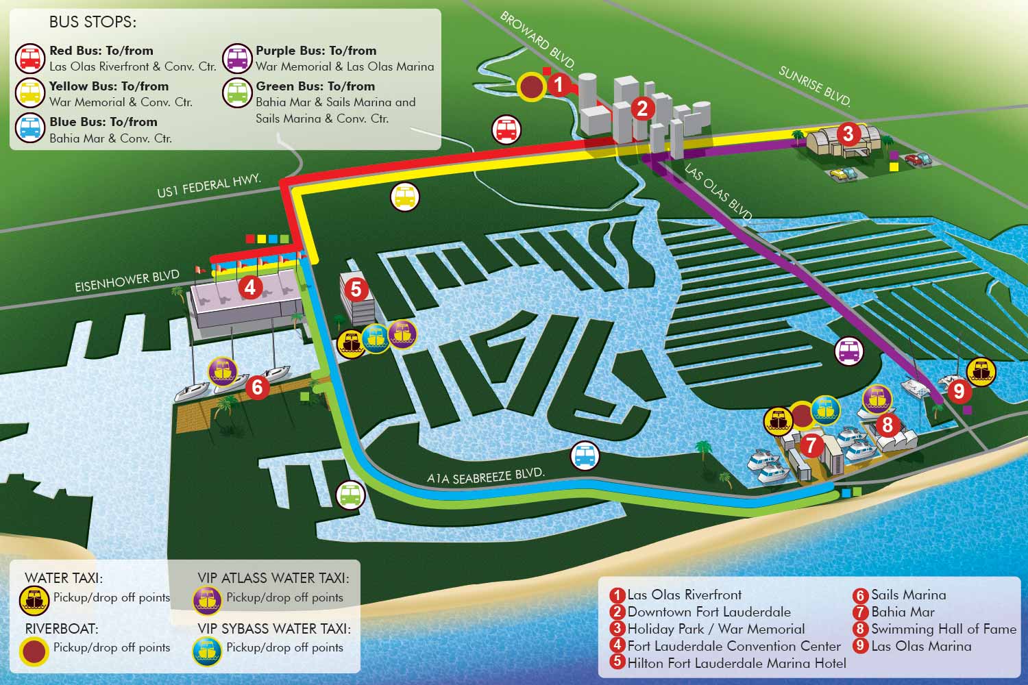
Transportation Map for the 2011 Fort Lauderdale International Boat Show
This distinctive illustrated map was created for the 2011 Fort Lauderdale International Boat Show, with a specific focus on attendee transit and connectivity between venues. The design prioritizes immediate clarity and user friendly navigation over strict geographic scale, presenting a functional overview of the transportation network in an engaging visual format.
The map adopts a highly illustrative style. Key venues and landmarks are represented by stylized spot illustrations, providing instant visual recognition. Transportation routes are clearly defined using a system of color coding, with each color corresponding to an icon explained in the map key located in the upper left corner. This allows users to quickly identify different shuttle or transport services.
Water taxi stops are distinctly marked with their own set of colored icons, detailed in a separate key in the lower left. Important destinations are numbered with white text on red dots, with a corresponding list provided in the lower right for easy reference. For further orientation, major road names are labeled directly on the map itself.
This project demonstrates how illustrative techniques can simplify complex logistical information. By combining clear color coded systems with intuitive artwork, the map effectively guides visitors through the various transit options, enhancing their overall experience at a major multi venue event.
For more examples of functional illustration for events, please visit my Map Portfolio.
Fort Lauderdale International Boat Show Maps:
- About Fort Lauderdale International Boat Show
- Bahia Mar, Swimming Hall of Fame & Las Olas Marina Maps: 2025 | 2024 | 2023 | 2022 | 2020 | 2019 | 2018 | 2017 | 2016 | 2015 | 2014 | 2013 | 2012 | 2011 | 2010
- Parking and Transportation Maps: 2025 | 2024 | 2023 | 2022 | 2020 | 2019 | 2018 | 2015 Bus | 2015 Water Taxi | 2014 | 2013 | 2012 | 2011
- Broward County Convention Center Maps: 2025 | 2024 | 2023 | 2022 | 2017 Sailfish Pavilion | 2017 | 2016 Sailfish Pavilion | 2016 | 2015 Sailfish Pavilion | 2015 | 2014 Sailfish Pavilion | 2014 | 2013 Sailfish Pavilion | 2013 | 2012 | 2011 | 2010
- Marinas Maps: 2025 | 2024 | 2023 | 2022 | 2019 | 2016
- Program Layouts: 2025 | 2024 | 2023 | 2022
- Signs: 2013 looking north | 2013 Yachting Tent
- Video: 2013 54th Annual
- Illustrations (not maps): 2014A | 2014B


PORTFOLIOS
- Illustration Portfolio: Start here for custom illustration and book covers. You can also browse illustrated maps and architectural rendering.
- Fine Art: I offer original paintings and drawings, including my Custom Halftone Series. You will also find mural work here.
- Graphic Design & Motion: View my graphic design portfolio. After that, explore motion design and animated illustrations.
- Maps by application: I create illustrated maps for boat shows, resorts, marinas, real estate, transportation, transit and parking, towns and cities, parks, and wayfinding.
- Additional project types: I also produce cover illustration, vehicle and vinyl wraps, proposal renderings, and street art.
- Illustration methods: My techniques include vector, isometric and axonometric, painting, black and white, GeoData maps, overhead maps, and custom halftones.
- Software portfolios: I work primarily in Adobe Photoshop, Adobe Illustrator, SketchUp Pro, and Adobe InDesign. For motion projects, I use Premiere Pro and After Effects.