Fort Lauderdale International Boat Show 2024 - Parking and Transportation Map
Client: Informa Markets
For more (and more up to date) information about the 2024 Fort Lauderdale International Boat Show visit their official site at FLIBS.com.
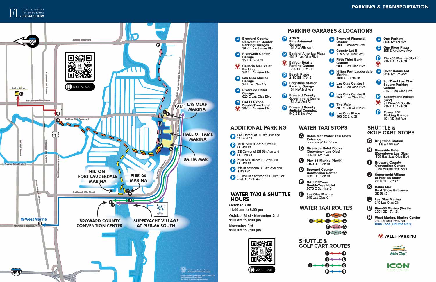
The 2024 Fort Lauderdale International Boat Show parking and transportation map represents a continuation of the clear and efficient design established in the previous year. Building upon the successful 2023 framework, this edition incorporates the necessary annual updates, such as revisions to parking facility listings and any adjustments to shuttle or water taxi routes, while maintaining the visual clarity and user focused layout that has proven effective.
The map adheres to the refined system implemented in 2023. Individual parking locations are not plotted as dots on the illustration itself, which prevents visual clutter. Instead, a complete list of parking facilities with their addresses is provided, allowing attendees to use GPS for precise navigation. Transit stops for shuttles and water taxis are clearly marked with a consistent system of color coded lettered icons, and routes are indicated with straightforward color coded lines. This separation of information types, detailed addresses off the map and clear graphical guidance on it, creates an intuitive tool for planning and onsite wayfinding.
This map functions as an essential resource across multiple platforms. It is published online well before the event, serving as a practical planning tool that helps build attendee anticipation through useful information rather than generic imagery. During the show, it is featured in the official printed program and adapted for onsite signage, providing clear guidance where it is needed most. This dual role underscores the value of a professionally designed transit map: it is both a strategic marketing asset and a critical piece of operational infrastructure, directly contributing to a smoother visitor experience.
The iterative refinement seen across recent years highlights the importance of a stable, well conceived design foundation. By updating a proven structure with current data, the map remains reliable for returning guests while staying accurate for each new show season.
For more examples of my work in creating clear informational graphics for complex events, please visit my Maps Portfolio.
Fort Lauderdale International Boat Show Maps 2024:
Bahia Mar, Swimming Hall of Fame & Las Olas Marina Map | Transit and Parking Map | Marinas (17th St Cswy) Map | Broward County Convention Center Map | Program LayoutMAPS FOR BOAT SHOWS IN FORT LAUDERDALE:


Fort Lauderdale International Boat Show Maps:
- About Fort Lauderdale International Boat Show
- Bahia Mar, Swimming Hall of Fame & Las Olas Marina Maps: 2025 | 2024 | 2023 | 2022 | 2020 | 2019 | 2018 | 2017 | 2016 | 2015 | 2014 | 2013 | 2012 | 2011 | 2010
- Parking and Transportation Maps: 2025 | 2024 | 2023 | 2022 | 2020 | 2019 | 2018 | 2015 Bus | 2015 Water Taxi | 2014 | 2013 | 2012 | 2011
- Broward County Convention Center Maps: 2025 | 2024 | 2023 | 2022 | 2017 Sailfish Pavilion | 2017 | 2016 Sailfish Pavilion | 2016 | 2015 Sailfish Pavilion | 2015 | 2014 Sailfish Pavilion | 2014 | 2013 Sailfish Pavilion | 2013 | 2012 | 2011 | 2010
- Marinas Maps: 2025 | 2024 | 2023 | 2022 | 2019 | 2016
- Program Layouts: 2025 | 2024 | 2023 | 2022
- Signs: 2013 looking north | 2013 Yachting Tent
- Video: 2013 54th Annual
- Illustrations (not maps): 2014A | 2014B
PORTFOLIO SELECTIONS
- Custom illustration & covers: Featuring bespoke illustration, book and magazine covers, hand-drawn maps, and building renderings.
- Fine art & murals: Including one-of-a-kind paintings and drawings, the Custom Halftone Series, and large-scale murals.
- Design & motion media: Covering graphic design, plus video and motion and animated illustration.
- Mapping by application: Tailored maps for marine events, hospitality, waterfront, property, transit, municipal, recreation, and navigation needs.
- Additional creative work: Includes editorial covers, vehicle graphics, concept renderings, and public art.
- Mediums & formats: Ranging from digital vector and isometric projection to traditional paint, line art, GIS-based, aerial-style, and halftone.
- Software expertise: Proficient in Photoshop, Illustrator, SketchUp, InDesign, and Premiere/After Effects for motion.