Broward County Convention Center - Sailfish Pavilion Visitor's Map
Client: Show Management
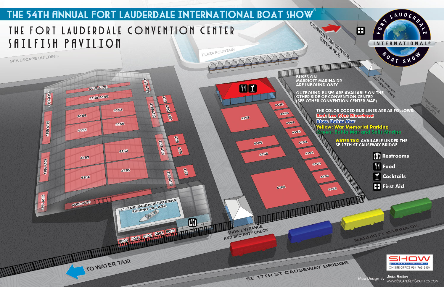
Broward County Convention Center - Sailfish Pavilion Visitor's Map for the Fort Lauderdale International Boat Show
This illustration presents the Sailfish Pavilion, the outdoor exhibit area adjacent to the main entrance of the Broward County Convention Center for the Fort Lauderdale International Boat Show. This was my inaugural year designing a map for this specific venue, and it was developed as an integral extension of the main convention center visual system.
To ensure perfect consistency and spatial accuracy, this exterior map was rendered from the same comprehensive three dimensional digital model used to create the detailed interior cutaway view of the convention center. This shared foundation guarantees that all structural elements align correctly between the two maps, providing attendees with a seamless navigational experience as they move between indoor and outdoor spaces.
The design maintains strong visual continuity with the interior map. The color coded shuttle buses and the set of graphical icons for amenities are identical, allowing for instant recognition. Exhibitor spaces within the pavilion are indicated using the same light rust colored rectangles and numbered spans, creating a uniform method for locating vendors. A distinctive illustrative technique was used for the venue tents themselves; they are rendered as ghostly, transparent forms. This allows viewers to see the layout of exhibitors inside while still understanding the tent structures that define the outdoor space.
This project exemplifies efficient and cohesive illustrative design. By leveraging an existing 3D model and a consistent visual language, the Sailfish Pavilion map was created not as a separate piece, but as a logical and integrated component of the overall event wayfinding system for the Fort Lauderdale International Boat Show.
This exterior map is a companion piece to the main interior view. To see the detailed illustration of the convention center interior it connects to, please visit the Fort Lauderdale Convention Center 2013 Map.
For more examples of coordinated environmental graphics and event cartography, please explore my full Map Portfolio.
Fort Lauderdale International Boat Show Maps:
- About Fort Lauderdale International Boat Show
- Bahia Mar, Swimming Hall of Fame & Las Olas Marina Maps: 2025 | 2024 | 2023 | 2022 | 2020 | 2019 | 2018 | 2017 | 2016 | 2015 | 2014 | 2013 | 2012 | 2011 | 2010
- Parking and Transportation Maps: 2025 | 2024 | 2023 | 2022 | 2020 | 2019 | 2018 | 2015 Bus | 2015 Water Taxi | 2014 | 2013 | 2012 | 2011
- Broward County Convention Center Maps: 2025 | 2024 | 2023 | 2022 | 2017 Sailfish Pavilion | 2017 | 2016 Sailfish Pavilion | 2016 | 2015 Sailfish Pavilion | 2015 | 2014 Sailfish Pavilion | 2014 | 2013 Sailfish Pavilion | 2013 | 2012 | 2011 | 2010
- Marinas Maps: 2025 | 2024 | 2023 | 2022 | 2019 | 2016
- Program Layouts: 2025 | 2024 | 2023 | 2022
- Signs: 2013 looking north | 2013 Yachting Tent
- Video: 2013 54th Annual
- Illustrations (not maps): 2014A | 2014B


