2022 Fort Lauderdale International Boat Show Map: A Return and a Transition
Illustration and Design by John Potter - Escape Key Graphics
Client: Informa Markets
For information about the Fort Lauderdale International Boat Show visit FLIBS.com
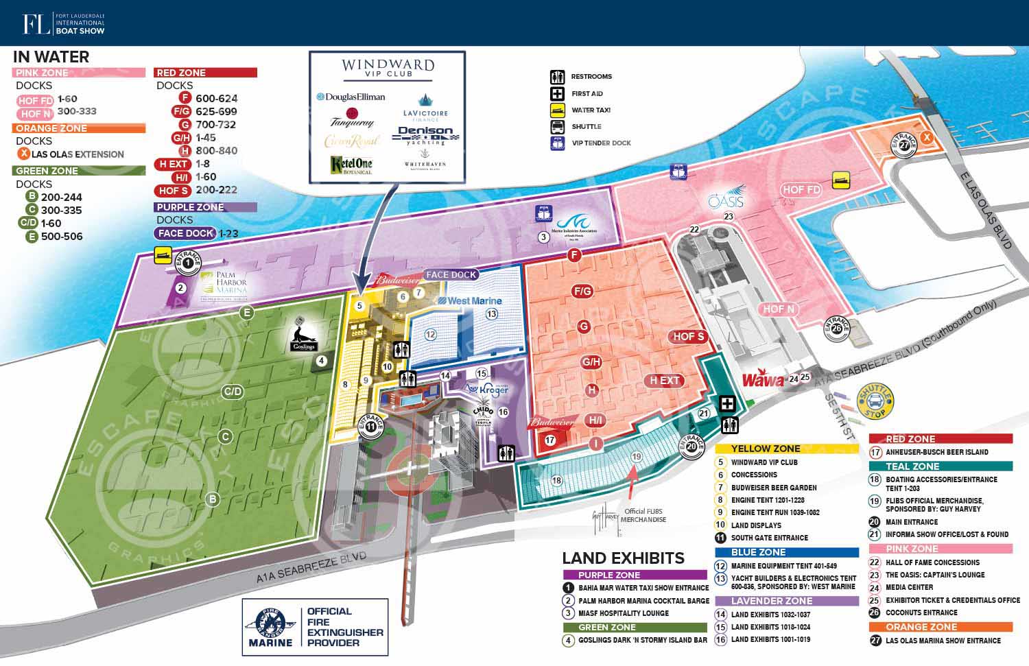
In 2022, I resumed my role as the map designer and illustrator for the Fort Lauderdale International Boat Show (FLIBS), returning after a brief hiatus. This reintroduction came with an evolved scope of responsibilities. My focus shifted from designing numerous individual exhibitor signs to handling the comprehensive page layout for the official show program. This change represented a comparable investment of creative labor and provided a welcome opportunity to apply my skills in Adobe InDesign, revisiting the desktop publishing work that formed the foundation of my early career.
A New Format for a Changing Show
A significant shift in 2022 was the formal move away from the standalone Z Card foldout map. The primary venue for the illustrated map became the printed show program, with the design expertly formatted as a clear, two page spread. This integration placed the essential navigational tool directly within the attendee's primary guidebook.
The map itself reflected the show's post pandemic recovery phase, with a slightly scaled back footprint. The Las Olas Marina section was truncated to match the current year's layout. I continued to work from the robust digital 3D model originally built in 2013, making precise modifications to docks and exhibitor tent placements to ensure accurate representation.
Refined Design for Enhanced Clarity
Several thoughtful design refinements were implemented to improve visual communication. The land based areas of the Swimming Hall of Fame, which hosted some show features, were reintegrated but rendered in grayscale. This deliberate choice effectively differentiated these ancillary spaces from the core, color coded show grounds, a technique successfully used in other event maps like the Palm Beach International Boat Show.
Additionally, the icons indicating amenities such as restrooms, transportation and such were simplified for faster recognition. These updates were made while preserving the established, intuitive color keying system that returning attendees relied upon for navigation.
This project illustrates the adaptive nature of long term client partnerships. The 2022 FLIBS map successfully balanced the need for updated accuracy with refined aesthetics, delivering a trusted navigational resource within a new publication format during a pivotal year for the event's resurgence.
This map marks a return to the annual series. To view the design from the previous edition I illustrated, please visit the 2020 FLIBS Illustrated Map.
For more examples of integrated publication design and event cartography, please explore my full Map Portfolio.
Fort Lauderdale International Boat Show Maps:
- About Fort Lauderdale International Boat Show
- Bahia Mar, Swimming Hall of Fame & Las Olas Marina Maps: 2025 | 2024 | 2023 | 2022 | 2020 | 2019 | 2018 | 2017 | 2016 | 2015 | 2014 | 2013 | 2012 | 2011 | 2010
- Parking and Transportation Maps: 2025 | 2024 | 2023 | 2022 | 2020 | 2019 | 2018 | 2015 Bus | 2015 Water Taxi | 2014 | 2013 | 2012 | 2011
- Broward County Convention Center Maps: 2025 | 2024 | 2023 | 2022 | 2017 Sailfish Pavilion | 2017 | 2016 Sailfish Pavilion | 2016 | 2015 Sailfish Pavilion | 2015 | 2014 Sailfish Pavilion | 2014 | 2013 Sailfish Pavilion | 2013 | 2012 | 2011 | 2010
- Marinas Maps: 2025 | 2024 | 2023 | 2022 | 2019 | 2016
- Program Layouts: 2025 | 2024 | 2023 | 2022
- Signs: 2013 looking north | 2013 Yachting Tent
- Video: 2013 54th Annual
- Illustrations (not maps): 2014A | 2014B
Fort Lauderdale International Boat Show (FLIBS): World’s Largest Marine Event & Custom Map Design Showcase:
The Fort Lauderdale International Boat Show (FLIBS) is widely recognized as the largest in-water boat show in the world, held annually in Fort Lauderdale, Florida - often called the “Yachting Capital of the World.” Produced by Informa Markets and owned by the Marine Industries Association of South Florida (MIASF), FLIBS draws a global audience of yacht owners, buyers, industry professionals, and enthusiasts to South Florida each fall.
Spanning nearly 90 acres and more than three million square feet of exhibit space across multiple waterfront locations - including Bahia Mar Yachting Center, Las Olas Marina, Pier Sixty-Six, Hall of Fame Marina, Convention Center, and more. FLIBS features over 1,300 boats and hundreds of exhibitors from more than 50 countries.
A Global Marine Marketplace and Lifestyle Event
Each five-day show attracts more than 100,000 visitors, ranging from seasoned yacht buyers and marine professionals to aspiring boat owners and lifestyle attendees. Vessels on display span a remarkable range from sleek sport boats and performance center consoles to luxury superyachts and large world debuts making FLIBS the premier destination to experience the latest innovations in boating, marine technology, and luxury maritime living.
The 2025 show continued this legacy, showcasing a robust lineup of superyachts and high-end brokerage listings valued at nearly $2 billion, alongside new builds and debut models that underscore Fort Lauderdale’s significance in global yacht markets.
Beyond boats, the show offers immersive experiences including interactive exhibits, luxury lifestyle activations, VIP lounges, educational seminars, networking events, and opportunities to connect with top marine manufacturers, brokers, designers, and service providers.
Economic Impact and Industry Influence
FLIBS is not only a key showcase for product launches and industry trends, it’s also a powerful economic engine. Studies consistently highlight the event’s substantial impact on Florida’s economy, generating well over $1.7 billion in annual economic output, supporting tens of thousands of jobs, and driving significant tax revenue and tourism activity across the region.
Custom Map Illustration by John Potter / Escape Key Graphics
For many attendees, one of the most memorable elements of the Fort Lauderdale International Boat Show is the illustrated map system used throughout the event, helping visitors navigate the sprawling multi-location layout with confidence.
From 2010 through present (with the exception of 2021), I had the privilege of serving as the primary map illustrator and designer for FLIBS, working closely with Informa Markets (previously Show Management) to evolve the look, usability, and precision of the show’s cartographic and visual wayfinding materials. These maps have been used:
-
As the official printed show map, tailored each year to reflect expanded and redesigned show footprints
-
Within the FLIBS mobile app to help users navigate docks, tents, marinas, and exhibitor displays
-
On exhibit signage and environmental graphics throughout multiple show locations
-
As transit, guide, and foldable maps for attendee convenience
Over the years, I’ve adapted styles, software workflows, and presentation formats to improve clarity, navigability, and visual impact as the show has grown in size and complexity. My designs aim to balance technical accuracy with artistic clarity, making it easy for attendees to find exhibitors, boats, services, and key show features while reinforcing the premium brand experience of FLIBS.
Why This Matters to Marine, Luxury, and Event Clients
If you’ve enjoyed the Fort Lauderdale International Boat Show and seen these maps in action, whether printed, on signage, or in your FLIBS app, then you’ve witnessed how strategic map design and illustration can elevate a major event. Great visual wayfinding not only improves user experience but strengthens brand perception, supports marketing, and enhances audience engagement across large-scale environments.
Whether you’re planning a future show, a corporate event, or a branded experience that needs clear, compelling visual communication, custom illustration and thoughtful map design can make a meaningful difference. Visit EscapeKeyGraphics.com to explore portfolio examples and learn how custom illustration can support your next project.
PORTFOLIO GALLERIES
- Illustration work: Start with custom illustration and cover design, then view illustrated maps and architectural renderings.
- Fine art: Discover original paintings and drawings, the Custom Halftone Series, and mural projects.
- Design & motion: Check out the graphic design gallery, then move on to motion graphics and animated illustration.
- Maps by sector: I produce illustrated maps for boat shows, resorts, marinas, real estate, transit & parking, towns & cities, parks, and wayfinding systems.
- More creative services: Additional offerings include cover illustration, vehicle wraps, proposal renderings, and street art.
- Artistic methods: My work spans vector art, isometric & axonometric views, traditional painting, black & white illustration, GeoData mapping, overhead perspectives, and halftone effects.
- Preferred software: I rely on Photoshop, Illustrator, SketchUp Pro, and InDesign, plus Premiere Pro & After Effects for motion projects.