Broward County Convention Center Exterior Map 2015: Optimizing the Outdoor Experience
Client: Show Management
For information about the Fort Lauderdale International Boat Show visit FLIBS.com
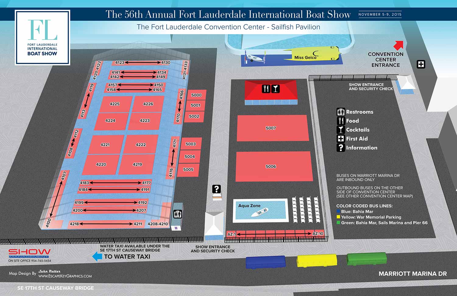
Map for the Fort Lauderdale International Boat Show 2015
This illustrated map presents the 2015 outdoor exhibition area at the Broward County Convention Center (Sailfish Pavilion), a key component of the Fort Lauderdale International Boat Show (FLIBS). As a recurring project with a proven design, this year's update focused on subtle refinements to optimize clarity while reinforcing the map's dual role as an essential wayfinding tool and a powerful piece of event marketing.
Developed from a detailed three dimensional digital model and presented in a clear aerial style, the map provides visitors with an immediate understanding of the Sailfish Pavilion's layout. The primary updates involved adjusting the angle of the view slightly and increasing the transparency of the tent structures to near full ghosting, a change made at the client's request to improve comprehension of the interior exhibitor layout. The design header was also updated by the in house art department, adopting a more contemporary and stark aesthetic that signaled a new visual direction.
Beyond these refinements, the core content was meticulously updated: exhibitor area placements and number ranges were revised to reflect the current year's floor plan, and features like The Aqua Zone were relocated on the map to match their new physical positions. The map retains its highly functional systems, using color coded indicators for shuttle routes and simple, recognizable icons for amenities, ensuring it performs flawlessly as a navigational aid.
The Strategic Value of Event Mapping
A map like this does more than guide visitors; it is a critical marketing asset. For a complex, multi venue event like FLIBS, a professional illustrated map reduces perceived friction and enhances the attendee experience from the first glance. It communicates organization, scale, and professionalism, setting a premium tone for the event. By providing clarity and confidence, it encourages exploration, increases dwell time at exhibits, and directly supports sponsor and exhibitor visibility. In essence, a well designed event map is not an optional extra; it is a fundamental tool for successful visitor engagement and a hallmark of a professionally produced show.
This exterior map is part of an annual series. To view the previous year's design, please visit the 2014 Exterior Map.
For more examples of how custom illustration enhances event wayfinding and marketing, please explore my full Maps Portfolio.
Fort Lauderdale International Boat Show Maps:
- About Fort Lauderdale International Boat Show
- Bahia Mar, Swimming Hall of Fame & Las Olas Marina Maps: 2025 | 2024 | 2023 | 2022 | 2020 | 2019 | 2018 | 2017 | 2016 | 2015 | 2014 | 2013 | 2012 | 2011 | 2010
- Parking and Transportation Maps: 2025 | 2024 | 2023 | 2022 | 2020 | 2019 | 2018 | 2015 Bus | 2015 Water Taxi | 2014 | 2013 | 2012 | 2011
- Broward County Convention Center Maps: 2025 | 2024 | 2023 | 2022 | 2017 Sailfish Pavilion | 2017 | 2016 Sailfish Pavilion | 2016 | 2015 Sailfish Pavilion | 2015 | 2014 Sailfish Pavilion | 2014 | 2013 Sailfish Pavilion | 2013 | 2012 | 2011 | 2010
- Marinas Maps: 2025 | 2024 | 2023 | 2022 | 2019 | 2016
- Program Layouts: 2025 | 2024 | 2023 | 2022
- Signs: 2013 looking north | 2013 Yachting Tent
- Video: 2013 54th Annual
- Illustrations (not maps): 2014A | 2014B


BROWSE MY WORK
- Illustration: Browse custom illustrations, book cover art, illustrated maps, and architectural renderings.
- Fine art: View original paintings and drawings, the Custom Halftone Series, and mural commissions.
- Graphic design & motion: See design projects, then watch motion reels and animated pieces.
- Maps by use case: Explore illustrated maps created for boat shows, resorts, marinas, real estate, transportation & parking, cities & towns, parks, and wayfinding.
- Specialty projects: Also check out cover design, vinyl & vehicle wraps, proposal renderings, and street art.
- Style & technique: Discover vector, isometric, painterly, monochrome, data-driven, bird's-eye, and halftone approaches.
- Tools I use: Everyday software includes Photoshop, Illustrator, SketchUp, and InDesign; motion work relies on Premiere & After Effects.