Site Plan Illustrated Map 2016: Defining the Outdoor Experience
Client: Show Management
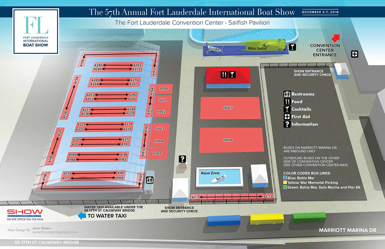
Map for the Fort Lauderdale International Boat Show 2016

This 2016 site plan illustrates the outdoor exhibition space adjacent to the Broward County Convention Center for the Fort Lauderdale International Boat Show (FLIBS). As a recurring annual project, this map required the precise updates necessary to maintain its role as a clear and reliable guide for the current year's event, while reinforcing the established visual system that attendees had come to trust.
The core revisions for this edition focused on the specific details that define the temporary outdoor venue. The placement of exhibitors within the Sailfish Pavilion was adjusted, the footprints of their allocated spaces were updated, and all corresponding booth number spans were meticulously revised. These accurate, data driven updates are essential, transforming a generic site plan into a functional, event specific navigational tool.
The overall design maintained the clean, contemporary aesthetic established in the previous year. The map continued to utilize a clear aerial perspective rendered from a detailed 3D model, with tent structures depicted with high transparency to allow a clear view of the interior layout. The functional color coding for shuttle routes and the consistent set of graphical icons for amenities were retained, ensuring intuitive use for both new and returning visitors.
The Strategic Advantage of Professional Site Mapping
A detailed site plan like this serves a critical dual purpose for any large scale outdoor event. Its primary function is, of course, practical wayfinding. It acts as an essential handout and an integral part of on site signage, directly reducing attendee frustration and enhancing the overall experience by making a complex space feel manageable and organized.
However, its value extends far beyond the event itself into the realm of strategic marketing. In a promotional landscape often filled with generic imagery, a custom illustrated site plan is a substantive asset. It communicates professionalism, careful planning, and a clear vision to potential attendees, sponsors, and exhibitors before the first tent is raised. It provides a tangible preview of the event's scale and layout, building anticipation and confidence. For any festival, exhibition, or outdoor show seeking to attract a sophisticated audience, a professional site map is not an optional extra; it is a fundamental component of effective communication and a visual promise of a well executed experience.
This exterior site plan is part of an annual series. To view the design from the previous year, please visit the Broward Convention Center Exterior Map 2015.
For more examples of how custom cartography supports both navigation and marketing for major events, please explore my full Maps Portfolio.
Fort Lauderdale International Boat Show Maps:
- About Fort Lauderdale International Boat Show
- Bahia Mar, Swimming Hall of Fame & Las Olas Marina Maps: 2025 | 2024 | 2023 | 2022 | 2020 | 2019 | 2018 | 2017 | 2016 | 2015 | 2014 | 2013 | 2012 | 2011 | 2010
- Parking and Transportation Maps: 2025 | 2024 | 2023 | 2022 | 2020 | 2019 | 2018 | 2015 Bus | 2015 Water Taxi | 2014 | 2013 | 2012 | 2011
- Broward County Convention Center Maps: 2025 | 2024 | 2023 | 2022 | 2017 Sailfish Pavilion | 2017 | 2016 Sailfish Pavilion | 2016 | 2015 Sailfish Pavilion | 2015 | 2014 Sailfish Pavilion | 2014 | 2013 Sailfish Pavilion | 2013 | 2012 | 2011 | 2010
- Marinas Maps: 2025 | 2024 | 2023 | 2022 | 2019 | 2016
- Program Layouts: 2025 | 2024 | 2023 | 2022
- Signs: 2013 looking north | 2013 Yachting Tent
- Video: 2013 54th Annual
- Illustrations (not maps): 2014A | 2014B


PORTFOLIOS
- Illustration Portfolio: Start here for custom illustration and book covers. You can also browse illustrated maps and architectural rendering.
- Fine Art: I offer original paintings and drawings, including my Custom Halftone Series. You will also find mural work here.
- Graphic Design & Motion: View my graphic design portfolio. After that, explore motion design and animated illustrations.
- Maps by application: I create illustrated maps for boat shows, resorts, marinas, real estate, transportation, transit and parking, towns and cities, parks, and wayfinding.
- Additional project types: I also produce cover illustration, vehicle and vinyl wraps, proposal renderings, and street art.
- Illustration methods: My techniques include vector, isometric and axonometric, painting, black and white, GeoData maps, overhead maps, and custom halftones.
- Software portfolios: I work primarily in Adobe Photoshop, Adobe Illustrator, SketchUp Pro, and Adobe InDesign. For motion projects, I use Premiere Pro and After Effects.