FLIBS 2022 Marinas Map: An Integrated Approach
Client: Informa Markets
For more (and more up to date) information about the 2022 Fort Lauderdale International Boat Show visit their official site at FLIBS.com.
Map for the Fort Lauderdale International Boat Show 2022
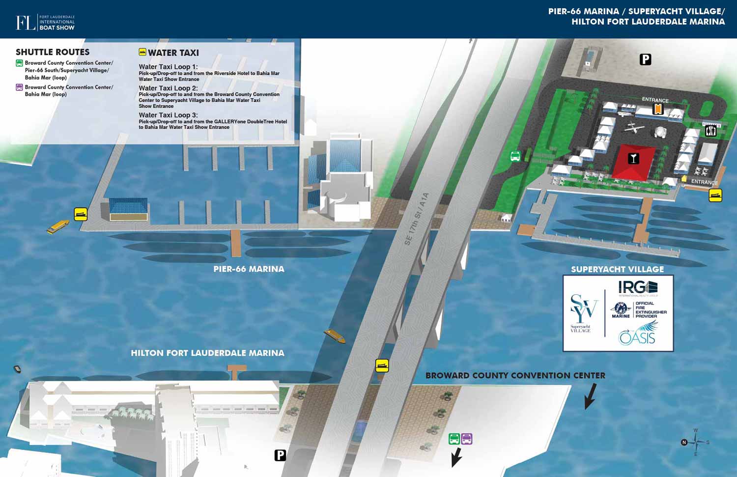
The 2022 Fort Lauderdale International Boat Show marinas map offers a consolidated and detailed overview of the event’s four primary waterfront venues. This illustrated piece evolved from a foundational three dimensional digital model originally built in 2016. Over the years, this model has been continuously updated, proving itself as a durable and indispensable asset for creating consistent, accurate visual materials.
For the 2022 show, the application of this model represented a significant shift in purpose. Earlier versions of the map functioned primarily as an orientation tool, framed within a wider geographic context that included landmarks like the Pier Sixty-Six tower and the Broward County Convention Center. The 2022 map deliberately crops out these elements to focus intently on the operational heart of the show: the four marinas and their specific spatial relationship to each other and the prominent 17th Street Causeway Bridge.
This refined focus transformed the map into a single, comprehensive guide for visitors navigating between all four venues, eliminating the previous need for separate individual marina maps. The efficiency of the underlying three dimensional model means that while this consolidated view was the primary public tool, generating focused maps for specific marinas or partners remains a straightforward process. This versatility was demonstrated in 2022 (and many other years) with the creation of a unique, custom map for Global Marine Travel, derived from the same core model to ensure informational accuracy.
The Practical Value of Pre-Event Cartography
Before a major event occurs, promotional materials often rely on atmospheric stock photography and generic graphics. While these elements help generate initial interest, they cannot communicate the practical realities of the event layout and offerings.
Illustrated maps solve this challenge by providing concrete, useful information during the planning phase. They allow organizers to share accurate, engaging visual content that helps potential attendees understand the scope and layout of the event in advance. This practical utility builds confidence and aids in decision making, ultimately helping to drive attendance.
Once the event begins, the map’s role shifts to that of an essential navigational aid, used across handouts, signage, and mobile devices to guide guests seamlessly. At Escape Key Graphics, we specialize in creating these dual-purpose assets: strategic marketing tools that become indispensable operational guides, ensuring a smoother, more informed experience for every visitor.
View my Maps Portfolio to see more examples of how detailed cartography can bring clarity and vision to complex events.
Fort Lauderdale International Boat Show Maps:
- About Fort Lauderdale International Boat Show
- Bahia Mar, Swimming Hall of Fame & Las Olas Marina Maps: 2025 | 2024 | 2023 | 2022 | 2020 | 2019 | 2018 | 2017 | 2016 | 2015 | 2014 | 2013 | 2012 | 2011 | 2010
- Parking and Transportation Maps: 2025 | 2024 | 2023 | 2022 | 2020 | 2019 | 2018 | 2015 Bus | 2015 Water Taxi | 2014 | 2013 | 2012 | 2011
- Broward County Convention Center Maps: 2025 | 2024 | 2023 | 2022 | 2017 Sailfish Pavilion | 2017 | 2016 Sailfish Pavilion | 2016 | 2015 Sailfish Pavilion | 2015 | 2014 Sailfish Pavilion | 2014 | 2013 Sailfish Pavilion | 2013 | 2012 | 2011 | 2010
- Marinas Maps: 2025 | 2024 | 2023 | 2022 | 2019 | 2016
- Program Layouts: 2025 | 2024 | 2023 | 2022
- Signs: 2013 looking north | 2013 Yachting Tent
- Video: 2013 54th Annual
- Illustrations (not maps): 2014A | 2014B


PORTFOLIOS
- Illustration Portfolio: Start here for custom illustration and book covers. You can also browse illustrated maps and architectural rendering.
- Fine Art: I offer original paintings and drawings, including my Custom Halftone Series. You will also find mural work here.
- Graphic Design & Motion: View my graphic design portfolio. After that, explore motion design and animated illustrations.
- Maps by application: I create illustrated maps for boat shows, resorts, marinas, real estate, transportation, transit and parking, towns and cities, parks, and wayfinding.
- Additional project types: I also produce cover illustration, vehicle and vinyl wraps, proposal renderings, and street art.
- Illustration methods: My techniques include vector, isometric and axonometric, painting, black and white, GeoData maps, overhead maps, and custom halftones.
- Software portfolios: I work primarily in Adobe Photoshop, Adobe Illustrator, SketchUp Pro, and Adobe InDesign. For motion projects, I use Premiere Pro and After Effects.