
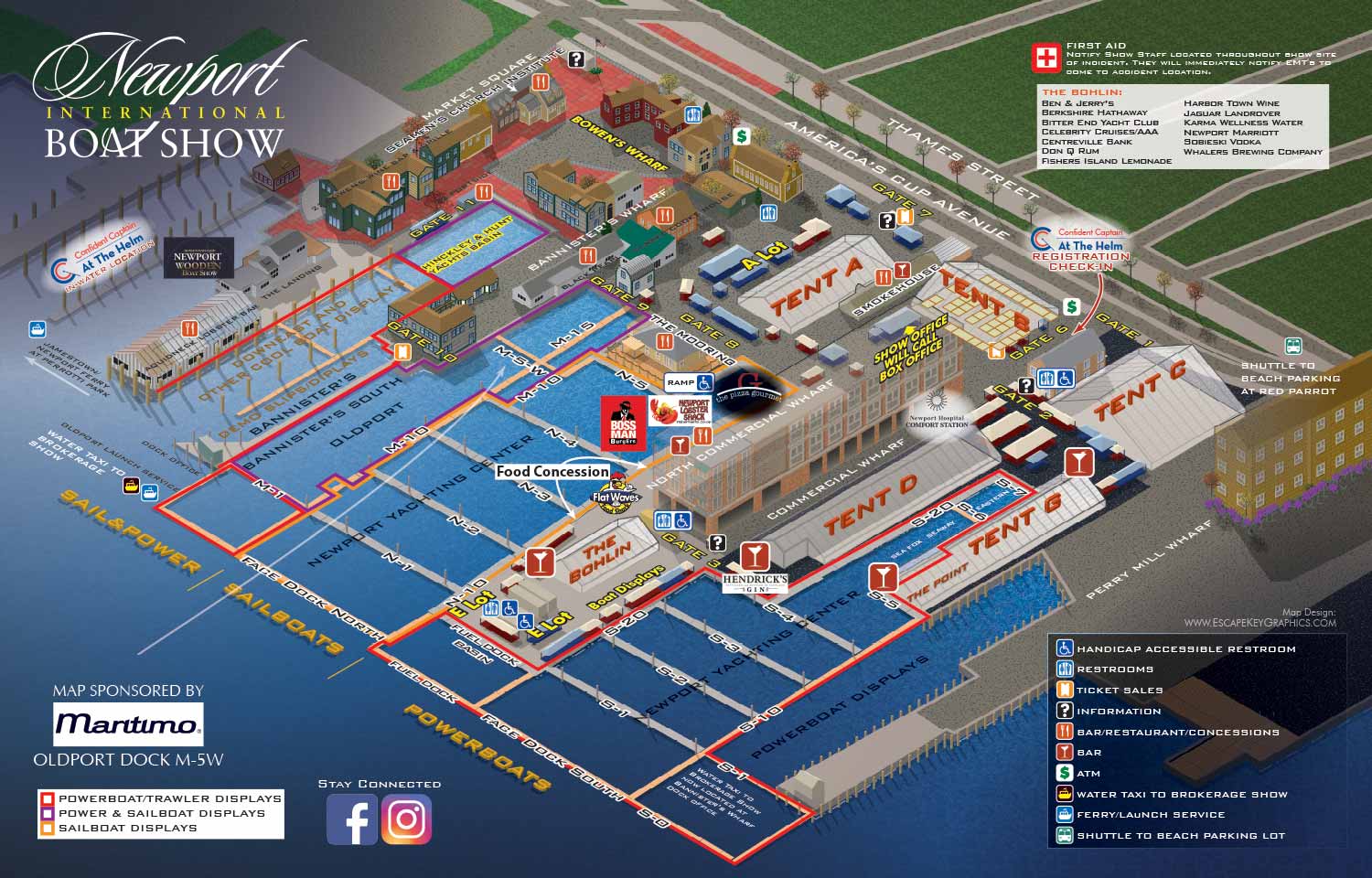
Illustrated Newport International Boat Show Guest Map - 2018
Client: The Newport Exhibition Group
About The Show
The Newport International Boat Show is one of the largest and most respected boat shows in the Northeast. It takes place each September across more than seventeen acres in historic downtown Newport, Rhode Island. The show spreads across multiple interconnected sites including the Newport Yachting Center, Hammetts Hotel, Perry Mill Wharf, Bowen's Wharf, Bannisters Wharf, and Market Square. The venue is dense with small, charming buildings, and the line between the show and the surrounding neighborhood is softer than at most other shows I work on.
For 2018
This map is the revised version for the Newport International Boat Show. It builds on the original axonometric vector illustration I created for The Newport Exhibition Group back in 2012.
By 2018, the map had settled into a stable look and feel. The viewing angle remained from the harbor looking inland, which gives a clear view of the layout while capturing the character of the waterfront. The color palette stayed earthy and muted, reflecting the natural tones of New England.
The main work this year, as in most years, was updating the floating dock and land exhibitor placements. The show changes slightly each year, and the map needs to reflect those changes accurately. The axonometric style means buildings and objects do not shrink with distance, so everything has equal visual weight. This makes the dense layout easier to read.
Why A Map
Maps like this are more than just wayfinding tools. Yes, they help attendees figure out where they are and where they want to go. But a well made map also does marketing work.
It gives potential visitors a real sense of the event before they arrive. They can study the layout, see what is where, and start imagining themselves walking the docks. That builds anticipation and excitement. A map is unique visual information that lifestyle photography cannot replace.
For exhibitors and sponsors, being on the map means being part of that pre show experience. And for show organizers, a consistent map year after year becomes a recognizable piece of the event's identity.
What I Can Do For You
If you have an event or any venue that needs a clear, detailed, and attractive map, I can help. I have been making maps like this since 2012 for boat shows, resorts, marinas, and more. Contact me and tell me about your project. I would be glad to do the same kind of work for you.
Maps For Newport International Boat Show:
- About Newport International Boat Show
- Main Map: 2026 | 2025 | 2024 | 2023 | 2022 | 2021 | 2019 | 2018 | 2017 | 2016 | 2015 | 2014 | 2013 | 2012
- Tent Details Map: 2026 | 2017 | 2016 | 2015 | 2014 | 2013 | 2012
- Video: 2012
EXPLORE MY PORTFOLIOS
- Illustration: Find custom illustration, book covers, illustrated maps, and architectural rendering.
- Fine Art: Browse original paintings and drawings, the Custom Halftone Series, and murals.
- Graphic Design & Motion: See my graphic design work, plus motion design and animated illustrations.
- Maps by industry: Illustrated maps tailored for boat shows, resorts, marinas, real estate, transit & parking, towns & cities, parks, and wayfinding.
- Other project types: Also available: cover art, vehicle & vinyl wraps, proposal renderings, and street art.
- Techniques: Explore work in vector, isometric & axonometric, painting, black & white, GeoData, overhead, and halftone styles. Recently I have also begun to use AI for some specific solutions.
- Software: Primary tools: Photoshop, Illustrator, SketchUp Pro, and InDesign. Motion work uses Premiere Pro & After Effects.