An illustrated guest map for the show, building on the foundation laid in 2012
Client: The Newport Exhibition Group
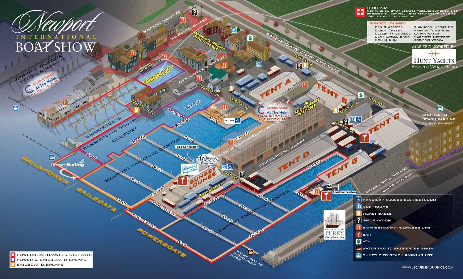
About the Show
The Newport International Boat Show takes place along the historic waterfront in Newport, Rhode Island. It is one of the oldest and most respected shows on the East Coast. The venue is dense with small, charming buildings, and the line between the show and the surrounding neighborhood is softer than at most other shows I work on.
About This Map
This is the revised Newport International Boat Show map for 2015. It builds on the original axonometric vector illustration I created for The Newport Exhibition Group in 2012.
For this map, the client requested a map that leans heavily on clear labeling rather than a keyed system. Docks, exhibit tents, and major landmarks are directly labeled to make the layout immediately understandable. Amenities are identified with a consistent set of graphical icons. This combination helps both first time visitors and returning attendees get oriented quickly.
The isometric perspective looks inland from the harbor. This gives the map an aerial quality that captures the scope of the event while keeping a clear sense of scale and spatial relationships.
To improve readability, different types of boat displays are color coded by zone. For example, areas dedicated solely to sailboats have their own color. The palette is intentionally earthy and muted, reflecting the natural tones of Newport's harbor and the surrounding New England landscape. This reinforces a sense of place and makes the map feel like it belongs to this specific location.
Beyond navigation, maps like this serve as marketing tools for the show. A well crafted illustrated map communicates professionalism and attention to detail. It becomes a branded asset that strengthens the show's presence online, in print, and on site.
What I Can Do For You
If you need a custom illustrated map for a boat show, an event, or any other venue, contact me. I have been making maps like this for over a decade and I would be glad to do it for you.
Maps For Newport International Boat Show:
- About Newport International Boat Show
- Main Map: 2025 | 2024 | 2023 | 2022 | 2021 | 2019 | 2018 | 2017 | 2016 | 2015 | 2014 | 2013 | 2012
- Tent Details Map: 2017 | 2016 | 2015 | 2014 | 2013 | 2012
- Video: 2012
PORTFOLIOS
- Illustration Portfolio: Start here for custom illustration and book covers. You can also browse illustrated maps and architectural rendering.
- Fine Art: I offer original paintings and drawings, including my Custom Halftone Series. You will also find mural work here.
- Graphic Design & Motion: View my graphic design portfolio. After that, explore motion design and animated illustrations.
- Maps by application: I create illustrated maps for boat shows, resorts, marinas, real estate, transportation, transit and parking, towns and cities, parks, and wayfinding.
- Additional project types: I also produce cover illustration, vehicle and vinyl wraps, proposal renderings, and street art.
- Illustration methods: My techniques include vector, isometric and axonometric, painting, black and white, GeoData maps, overhead maps, and custom halftones.
- Software portfolios: I work primarily in Adobe Photoshop, Adobe Illustrator, SketchUp Pro, and Adobe InDesign. For motion projects, I use Premiere Pro and After Effects.