
Illustrated Campus Map with an Architectural Feel and an Aerial View
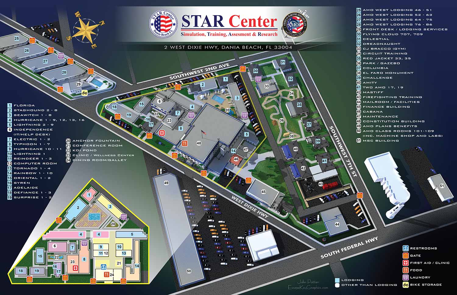
Campus Map - I have just completed the new map for the American Maritime Officers' Star Center Campus in Dania Beach, Florida. STAR Center is a not-for-profit maritime training school that is the top choice of inland and ocean-going professional mariners throughout the world. In short they train ship captains, engineers and the like. It was a fun map to create and I got to meet some great people while working on this project. I hope this new map helps mariners better navigate the Star Center Campus while they are in training.
The map shows an aerial view of the campus as a 3D model, but clear enough and acute enough angle to easily use as a map. This also makes finding landmarks much easier since they appear more real on an illustrated map. This map also features a small inset overhead map to show the interior of a cluster of buildings.
I would love to create a map for your school, business, evil lair etc. Please contact me for your next illustrated map project.
For more information about American Maritime Officers' Star Center visit their site at AMO-Union.org. American Maritime Officers is the largest union of U.S. merchant marine officers. American Maritime Officers members work aboard commercial, military sealift and government vessels in domestic and international deep-sea trades and missions, on the Great Lakes and in U.S. inland waterways and harbors. Their campus is conveniently located in Dania Beach, Florida close to the Fort Lauderdale/Hollywood International Airport.
Escape Key Graphics’ vector based maps can be blown up to a poster of any size with little or no degradation and Escape Key Graphics’ 3D maps can be rendered from different angles and zoom extents creating endless new possibilities. The 3D method can also provide a more realistic look than the vector method. In both cases buildings, paths and everything else in your map is like an object that can be moved, shrunk, deleted, etc, making revisions easy and quick. Expansion of your park, site, or facilities seldom means recreating your map from scratch.
Escape Key Graphics can create great maps for boat shows, towns and cities, campuses, hospitals, housing complexes or just about any other place. Escape Key Graphics can show how work flows through your factory, how an ecosystem works or produce any of a number of other map like visual solutions.
PORTFOLIO SELECTIONS
- Custom illustration & covers: Featuring bespoke illustration, book and magazine covers, hand-drawn maps, and building renderings.
- Fine art & murals: Including one-of-a-kind paintings and drawings, the Custom Halftone Series, and large-scale murals.
- Design & motion media: Covering graphic design, plus video and motion and animated illustration.
- Mapping by application: Tailored maps for marine events, hospitality, waterfront, property, transit, municipal, recreation, and navigation needs.
- Additional creative work: Includes editorial covers, vehicle graphics, concept renderings, and public art.
- Mediums & formats: Ranging from digital vector and isometric projection to traditional paint, line art, GIS-based, aerial-style, and halftone.
- Software expertise: Proficient in Photoshop, Illustrator, SketchUp, InDesign, and Premiere/After Effects for motion. More recently I have worked with AI.
